|
Sunda Islands
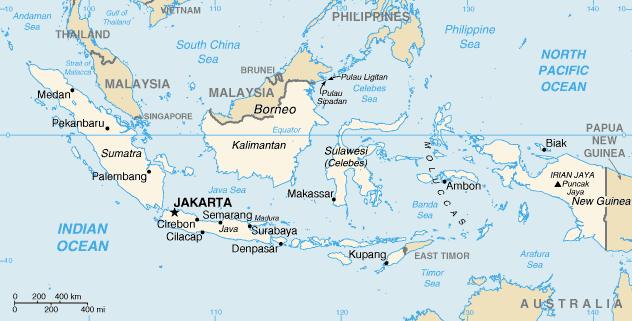
The Sunda Islands ( id, Kepulauan Sunda) are a archipelago , group of islands in the Malay Archipelago.Chisholm, Hugh, ed. (1911). wikisource:1911_Encyclopædia_Britannica/Sunda_Islands, "Sunda Islands" . ''Encyclopædia Britannica Eleventh Edition, Encyclopædia Britannica''. 26 (11th ed.). Cambridge University Press. They consist of the Greater Sunda Islands and the Lesser Sunda Islands. Administration The Sunda Islands are divided among four countries: Brunei, East Timor, Indonesia and Malaysia. The majority of these islands fall under the jurisdiction of Indonesia. Borneo is part of Brunei, Indonesia and Malaysia. Timor is part of East Timor and Indonesia. Sebatik Island, Sebatik is part of Indonesia and Malaysia. List of islands * Greater Sunda Islands ** Borneo ** Java ** Sulawesi ** Sumatra * Lesser Sunda Islands (from west to east) ** Bali ** Lombok ** Sumbawa ** Sumba ** Komodo (island), Komodo ** Flores ** Savu ** Rote Island, Rote ** Timor ** Alor Archipelago * ... [...More Info...] [...Related Items...] OR: [Wikipedia] [Google] [Baidu] |
Greater Sunda Islands
The Greater Sunda Islands ( Indonesian and Malay: ''Kepulauan Sunda Besar'') are four tropical islands situated within Indonesian Archipelago, in the Pacific Ocean. The islands, Borneo, Java, Sulawesi and Sumatra, are internationally recognised for their ecological diversity and rich culture. Together with the Lesser Sunda Islands to their southeast, they comprise the archipelago known as the Sunda Islands. Mainly part of Indonesia, each island is diverse in its ethnicity, culture and biological attributes. The islands have a long and rich history which has shaped their cultural backgrounds. Sumatra Geography Sumatra is the second largest, most westerly oriented Indonesian island, and the sixth largest island globally. Spanning , Sumatra is home to human civilisations and tropical rainforests, which harbour a huge range of wildlife. Its close proximity to the Equator (1º S, 101º E) dictates its tropical climate, so that it is subject to the forces of climatic events El Ni ... [...More Info...] [...Related Items...] OR: [Wikipedia] [Google] [Baidu] |
Bali
Bali () is a province of Indonesia and the westernmost of the Lesser Sunda Islands. East of Java and west of Lombok, the province includes the island of Bali and a few smaller neighbouring islands, notably Nusa Penida, Nusa Lembongan, and Nusa Ceningan to the southeast. The provincial capital, Denpasar, is the most populous city in the Lesser Sunda Islands and the second-largest, after Makassar, in Eastern Indonesia. The upland town of Ubud in Greater Denpasar is considered Bali's cultural centre. The province is Indonesia's main tourist destination, with a significant rise in tourism since the 1980s. Tourism-related business makes up 80% of its economy. Bali is the only Hindu-majority province in Indonesia, with 86.9% of the population adhering to Balinese Hinduism. It is renowned for its highly developed arts, including traditional and modern dance, sculpture, painting, leather, metalworking, and music. The Indonesian International Film Festival is held every year in ... [...More Info...] [...Related Items...] OR: [Wikipedia] [Google] [Baidu] |
List Of Islands Of Indonesia
The islands of Indonesia, also known as the Indonesian Archipelago ( id, Kepulauan Indonesia) or Nusantara, may refer either to the islands comprising the country of Indonesia or to the geographical groups which include its islands. History The exact number of islands comprising Indonesia varies among definitions and sources. According to the Law No 9/1996 on Maritime Territory of Indonesia, of 17,508 officially listed islands within the territory of the Republic of Indonesia. According to a geospatial survey conducted between 2007 and 2010 by the National Coordinating Agency for Survey and Mapping (Bakorsurtanal), Indonesia has 13,466 islands. However, according to earlier survey in 2002 by National Institute of Aeronautics and Space (LAPAN), the Indonesian archipelago has 18,307 islands, and according to the CIA ''World Factbook'', there are 17,508 islands. The discrepancy of the numbers of Indonesian islands was because that the earlier surveys include " tidal islands"; ... [...More Info...] [...Related Items...] OR: [Wikipedia] [Google] [Baidu] |
Banda Arc
The Banda Arc (main arc, Inner, and Outer) is a set of island arcs in eastern Indonesia. It is the result of the collision of a continent and an intra-oceanic island arc. The presently active arc is located on what appears to be oceanic crust whereas the associated subduction trench is underlain by continental crust. The convergence of the Indo-Australian plates and Eurasia resulted in the formation of the Sunda and Banda island arcs. The transitional zone between the arcs is located south of Flores Island and is characterized by the change in the tectonic regime along the boundary. Terminology Some academic literature refers to the arcs by location – so that main arc can be referred to as the 'southern', the 'western' Situated at the centre of three converging and colliding major tectonic plates, Indo-Australia, Eurasia, Pacific, the Banda arc includes young oceanic crust enclosed by a volcanic inner arc, outer arc islands and a trough parallel to the Australian continen ... [...More Info...] [...Related Items...] OR: [Wikipedia] [Google] [Baidu] |
Tanimbar Islands
The Tanimbar Islands, also called ''Timur Laut'', are a group of about 65 islands in the Maluku province of Indonesia. The largest and most central of the islands is Yamdena; others include Selaru to the southwest of Yamdena, Larat and Fordata to the northeast, Maru and Molu to the north, and Seira, Wuliaru, Selu, Wotap and Makasar to the west. The Indonesian phrase ''timur laut'' means "east of the sea" or "northeast". The Tanimbar Islands are administered as the ''Tanimbar Islands Regency'' ( id, Kabupaten Kepulauan Tanimbar), a regency of Maluku. The Regency covers a land area of 10,102.92 km2, and it had a population of 105,341 at the 2010 census, rising to 123,572 at the 2020 census. The principal town and administrative centre lies at Saumlaki. Geography Geographically, the northeast islands are still part of the Lesser Sunda Islands. The Aru Islands and Kai Islands lie to the northeast, and Babar Island and Timor lie to the west. The islands separate the Banda ... [...More Info...] [...Related Items...] OR: [Wikipedia] [Google] [Baidu] |
Barat Daya Islands
The Barat Daya Islands ( id, Kepulauan Barat Daya) are a group of islands in the Maluku province of Indonesia. The Indonesian phrase ''barat daya'' means 'south-west'. Geography These islands are located off the eastern end of East Timor. Wetar is the largest island in the group. To the west, the Ombai Strait separates Wetar from Alor Island, part of East Nusa Tenggara. The Wetar Strait separates Wetar from Timor to the south. Even though included in the Indonesian Maluku province political division, the southwestern islands are geographically part of the Lesser Sunda Islands. Rainfall is limited with a dry season between October and December when some of the islands appear as dry savannah. The Barat Daya Islands except Wetar are part of the Banda Sea Islands moist deciduous forests ecoregion. Wetar and Timor comprise the Timor and Wetar deciduous forests ecoregion. Most of the islands are barren, infertile and minimally forested. Together with Timor, Nusa Tenggara, Sulawesi, ... [...More Info...] [...Related Items...] OR: [Wikipedia] [Google] [Baidu] |
Atauro
Atauro ( pt, Ilha de Ataúro, Tetum and Indonesian: ''Pulau Atauro'' or ''Ata'uro''), also known as Kambing Island ( id, Pulau Kambing), is an island and municipality ( pt, Município Ataúro, links=no, tet, Munisípiu Atauro, links=no or ) of East Timor. Atauro is a small oceanic island situated north of Dili, on the extinct Wetar segment of the volcanic Inner Banda Arc, between the Indonesian islands of Alor and Wetar. The nearest island is the Indonesian island of Liran, to the northeast. At the 2015 census, it had 9,274 inhabitants. Atauro was one of the administrative posts (formerly subdistricts) of Dili Municipality until it became a separate municipality with effect from 1 January 2022. Etymology ''Atauro'' means 'goat' in the local language, and the island is also known as ''Kambing Island'' (''Pulau Kambing'') by the Indonesians (''Kambing'' means 'goat' in Indonesian). The island was so named because of the large number of goats kept there. Geography ... [...More Info...] [...Related Items...] OR: [Wikipedia] [Google] [Baidu] |
Rote Island
Rote Island ( id, Pulau Rote, also spelled ''Roti'') is an island of Indonesia, part of the East Nusa Tenggara province of the Lesser Sunda Islands. According to legend, this island got its name accidentally when a lost Portuguese sailor arrived and asked a farmer where he was. The surprised farmer, who could not speak Portuguese, introduced himself, "Rote". Geography Rote lies 500 km (310.686 miles) northwest of the Australian coast and 150 km (105.633 miles) north of the Ashmore and Cartier Islands. The island is situated to the southwest of the larger island of Timor. To the north is the Savu Sea, and to the south is the Timor Sea. To the west lie Savu and Sumba. The uninhabited ''Pamana'' (or ''Ndana'') island, just south of Rote, with an area of , is the southernmost island of Indonesia. Along with some other nearby small islands, such as Nuse Island, Ndao island, it forms the kabupaten (regency) of Rote Ndao Regency, which in 2010 decennial census recor ... [...More Info...] [...Related Items...] OR: [Wikipedia] [Google] [Baidu] |
Savu
Savu ( id, Sawu, also known as Sabu, Havu, and Hawu) is the largest of a group of three islands, situated midway between Sumba and Rote, west of Timor, in Indonesia's eastern province, East Nusa Tenggara. Ferries connect the islands to Waingapu on Sumba, Ende on Flores, and Kupang in West Timor. Flying to Savu through Susi Air from Kupang, Ende, and Waingapu is also possible. Geography The Savu Islands (Indonesian: ''Kepulauan Sawu'') include Rai Hawu (or Savu), Rai Jua, and Rai Dana. The three islands are fringed by coral reefs and sandy beaches. Rai Hawu is the principal island. Rai Jua is a smaller island west of Rai Hawu. Rai Dana is a small, uninhabited island, situated 30 km southwest of Rai Jua. From April to October, deep ocean swells pound the southern coastlines. The land is covered for the most part by grassland and palms. The climate of this island is tropical savanna (''Aw'') with dry months for much of the year because of the dry winds which blow from Austr ... [...More Info...] [...Related Items...] OR: [Wikipedia] [Google] [Baidu] |
Flores
Flores is one of the Lesser Sunda Islands, a group of islands in the eastern half of Indonesia. Including the Komodo Islands off its west coast (but excluding the Solor Archipelago to the east of Flores), the land area is 15,530.58 km2, and the population was 1,878,875 in the 2020 Census (including various offshore islands); the official estimate as at mid 2021 was 1,897,550. The largest towns are Maumere and Ende. The name ''Flores'' is the Portuguese and Spanish word for "Flowers". Flores is located east of Sumbawa and the Komodo islands, and west of the Solor Islands and the Alor Archipelago. To the southeast is Timor. To the south, across the Sumba Strait, is Sumba island and to the north, beyond the Flores Sea, is Sulawesi. Among all islands containing Indonesian territory, Flores is the 10th most populous after Java, Sumatra, Borneo ( Kalimantan), Sulawesi, New Guinea, Bali, Madura, Lombok, and Timor and also the 10th biggest island of Indonesia. Unt ... [...More Info...] [...Related Items...] OR: [Wikipedia] [Google] [Baidu] |
Komodo (island)
Komodo ( id, Pulau Komodo) is one of the 17,508 islands that comprise the Republic of Indonesia. The island is particularly notable as the habitat of the Komodo dragon, the largest lizard on Earth, which is named after the island. Komodo Island has a surface area of 390 square kilometres and a human population of over two thousand. The people of the island are descendants of former convicts who were exiled to the island and who have mixed with Bugis from Sulawesi. The people are primarily adherents of Islam but there are also Christian and Hindu congregations. Komodo is part of the Lesser Sunda chain of islands and forms part of the Komodo National Park. In addition, the island is a popular destination for diving. Administratively, it is part of the East Nusa Tenggara province. Description Komodo is part of the Lesser Sunda chain of islands and forms part of the Komodo National Park. It lies between the substantially larger neighboring islands Sumbawa to the west and Flores t ... [...More Info...] [...Related Items...] OR: [Wikipedia] [Google] [Baidu] |


