|
Sabancaya
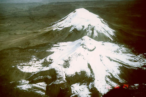
Sabancaya is an active stratovolcano in the Andes of southern Peru, about northwest of Arequipa. It is considered part of the Central Volcanic Zone of the Andes, one of the three distinct volcanic belts of the Andes. The Central Volcanic Zone includes a number of volcanoes, some of which like Huaynaputina have had large eruptions and others such as Sabancaya and Ubinas have been active in historical time. Sabancaya forms a volcanic complex together with Hualca Hualca to the north and Ampato to the south and has erupted andesite and dacite. It is covered by a small ice cap which leads to a risk of lahars during eruptions. Sabancaya has generated numerous long lava flows especially during the early Holocene, while activity in the later Holocene has been more Explosive eruption, explosive. Historical reports indicate eruptions during the 18th century. The volcano returned to activity in 1986, culminating in a large eruption in 1990. Since then it has been continuously active with t ... [...More Info...] [...Related Items...] OR: [Wikipedia] [Google] [Baidu] |
Ampato
Ampato (possibly from Quechua ''hamp'atu'' or from Aymara ''jamp'atu'', both meaning "frog") is a dormant stratovolcano in the Andes of southern Peru. It lies about northwest of Arequipa and is part of a north-south chain that includes the volcanoes Hualca Hualca and Sabancaya, the last of which has been active in historical time. Ampato consists of three volcanic cones, which lie on top of an older eroded volcanic edifice. They were formed sequentially by extrusion of lava flows, but Ampato has also had explosive eruptions which have deposited ash, lapilli and pumice in the surrounding landscape. One young lava flow has been dated to 17,000 ± 6,000 years before present, but a summit lava dome is even younger, and Holocene ash layers in surrounding peat bogs may testify to the occurrence of recent eruptions. The present-day volcano is covered by an ice cap, and during the last glacial maximum glaciers advanced to low altitudes. In 1995, an Inca mummy known as Mummy Juanita was ... [...More Info...] [...Related Items...] OR: [Wikipedia] [Google] [Baidu] |
Hualca Hualca
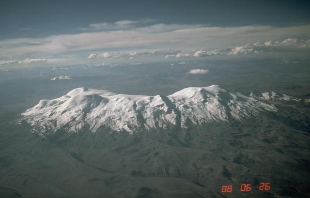
Hualca Hualca (possibly from Aymara and Quechua ''wallqa'' collar) is an extinct volcano in Arequipa Region in the Andes of Peru. It has a height of . It is located at the Peruvian province of Caylloma. Geography and geomorphology Hualca Hualca is part of the Central Volcanic Zone of the Andes, a volcanic belt which occurs where the Nazca Plate subducts beneath the South America Plate. Volcanoes in Peru that are part of the Central Volcanic Zone include Ampato, Casiri, Chachani, Coropuna, El Misti, Huaynaputina, Pichu Pichu, Sabancaya, Sara Sara, Solimana, Ticsani, Tutupaca, Ubinas and Yucamane. Hualca Hualca forms a volcanic complex with the two southerly volcanoes Sabancaya and Ampato. It is older (Pliocene-Pleistocene) and more heavily eroded than these two volcanoes; they are all constructed on Neogene ignimbrites, one of which was dated to 2.2 ± 1.5 million years ago. The volcano has erupted andesitic lava flows; one series of such flows exceeds a thick ... [...More Info...] [...Related Items...] OR: [Wikipedia] [Google] [Baidu] |
Huaynaputina
Huaynaputina ( ; ) is a volcano in a volcanic high plateau in southern Peru. Lying in the Central Volcanic Zone of the Andes, it was formed by the subduction of the oceanic Nazca Plate under the continental South American Plate. Huaynaputina is a large volcanic crater, lacking an identifiable mountain profile, with an outer stratovolcano and three younger volcanic vents within an :wiktionary:amphitheatre, amphitheatre-shaped structure that is either a former caldera or a remnant of glacial erosion. The volcano has erupted dacite, dacitic magma. In the Holocene, Huaynaputina has erupted several times, including on 19February 1600 – the largest eruption ever recorded in South America – which continued with a series of events into March. Witnessed by people in the city of Arequipa, it killed at least 1,000–1,500 people in the region, wiped out vegetation, buried the surrounding area with of volcanic rock and damaged infrastructure and economic resources. The eruption had a si ... [...More Info...] [...Related Items...] OR: [Wikipedia] [Google] [Baidu] |
Ubinas
Ubinas is an active stratovolcano in the Moquegua Region of southern Peru, approximately east of the city of Arequipa. Part of the Central Volcanic Zone of the Andes, it rises above sea level. The volcano's summit is cut by a and caldera, which itself contains a smaller crater. Below the summit, Ubinas has the shape of an upwards-steepening cone with a prominent notch on the southern side. The gently sloping lower part of the volcano is also known as Ubinas I and the steeper upper part as Ubinas II; they represent different stages in the volcano's geological history. The most active volcano in Peru, Ubinas has a history of small to moderate explosive eruptions as well as a few larger eruptions, such as in 1667, along with persistent degassing and ash emissions. Activity at the volcano began in the Pleistocene epoch, and led to the growth of the current mountain in two phases. Among the recent eruptions was the 2006–2007 event, which produced eruption columns and led t ... [...More Info...] [...Related Items...] OR: [Wikipedia] [Google] [Baidu] |
Coropuna
Coropuna is a dormant compound volcano located in the Andes mountains of southeast-central Peru. The upper reaches of Coropuna consist of several perennially snowbound conical summits, lending it the name Nevado Coropuna in Spanish. The complex extends over an area of and its highest summit reaches an altitude of above sea level. This makes the Coropuna complex the third-highest of Peru. Its thick ice cap is the most extensive in Earth's tropical zone, with several outlet glaciers stretching out to lower altitudes. Below an elevation of , there are various vegetation belts which include trees, peat bogs, grasses and also agricultural areas and pastures. The Coropuna complex consists of several stratovolcanos. These are composed chiefly of ignimbrites and lava flows on a basement formed by Middle Miocene ignimbrites and lava flows. The Coropuna complex has been active for at least five million years, with the bulk of the current cone having been formed during the Quat ... [...More Info...] [...Related Items...] OR: [Wikipedia] [Google] [Baidu] |
Solimana (volcano)
Solimana is a volcanic massif in the Andes of Peru, South America, that is approximately high. It is considered an extinct stratovolcano that is part of the Central Volcanic Zone, one of the volcanic belts of the Andes. It features a caldera as well as traces of a sector collapse and subsequent erosion. The volcano is glaciated. Geomorphology and geography Regional It is situated in the Arequipa Region, Condesuyos Province, in the districts of Chichas and Salamanca, and in the La Unión Province, in the districts of Cotahuasi and Toro. Several towns lie around the volcano. Solimana is part of the Peruvian segment of the Central Volcanic Zone of the Andes. The Central Volcanic Zone in this segment has both generated large composite volcanoes which rise above their basement and monogenetic volcanoes and volcanic fields. This zone of volcanoes includes, from northwest to southeast, Sara Sara, Solimana, Coropuna, Andagua volcanic field, Huambo volcanic field, Ampato, ... [...More Info...] [...Related Items...] OR: [Wikipedia] [Google] [Baidu] |
Sara Sara
Sara Sara is a volcano lying between Lake Parinacochas and the Ocoña River in Peru. It is situated in the Parinacochas Province and the Paucar del Sara Sara Province. The volcano formed during the Pleistocene during four different stages of volcanic activity, which constructed a volcanic edifice with an oval outline consisting of lava flows and lava domes. The volcano was glaciated during the last glacial maximum; it may still feature glaciers. The last eruption was about 14,000 years ago and future eruptions are possible. The volcano was worshipped by the local population, and an Inca mummy of a 15-year old girl was found on the summit by archaeologists. Geography and geomorphology Sara Sara lies within the sub-range of the Andes. Administratively, it is located in the Parinacochas and Paucar del Sara Sara Provinces of the Ayacucho Region, Peru. The town of Pausa lies away from the volcano, and agriculture occurs in the valleys of the area. A disused road passes over t ... [...More Info...] [...Related Items...] OR: [Wikipedia] [Google] [Baidu] |
Ticsani
Ticsani is a volcano in Peru northwest of Moquegua and consists of two volcanoes ("Old Ticsani" and "Modern Ticsani") that form a complex. "Old Ticsani" is a compound volcano that underwent a large collapse in the past and shed of mass down the Rio Tambo valley. Today an arcuate ridge remains of this edifice. "Modern Ticsani" is a complex of three lava domes which were emplaced during the Holocene. Two large eruptions took place during the Holocene, producing the so-called "Grey Ticsani" and "Brown Ticsani" deposits; the last eruption occurred after the 1600 eruption of neighbouring Huaynaputina. The volcano is seismically active and features active hot springs and fumaroles; since 2015 the volcano is monitored by the Peruvian government. Geography and geomorphology Ticsani is in the Ichuna District of Peru, northwest of Moquegua. The Putina River passes northwest and the Carumas River southwest of the volcano. The area is remote, which has hampered exploration effort ... [...More Info...] [...Related Items...] OR: [Wikipedia] [Google] [Baidu] |
Tutupaca
Tutupaca is a volcano in the region of Tacna in Peru. It is part of the Peruvian segment of the Central Volcanic Zone, one of several volcanic belts in the Andes. Tutupaca consists of three overlapping volcanoes formed by lava flows and lava domes made out of andesite and dacite, which grew on top of older volcanic rocks. The highest of these is usually reported to be tall and was glaciated in the past. Several volcanoes in Peru have been active in recent times, including Tutupaca. Their volcanism is caused by the subduction of the Nazca Plate beneath the South America Plate. One of these volcanoes collapsed in historical time, probably in 1802, generating a large debris avalanche with a volume likely exceeding and a pyroclastic flow. The associated eruption was among the largest in Peru for which there are historical records. The volcano became active about 700,000 years ago, and activity continued into the Holocene, but whether there were historical eruptions was initial ... [...More Info...] [...Related Items...] OR: [Wikipedia] [Google] [Baidu] |
Chachani
Chachani is a volcanic group in southern Peru, northwest of the city of Arequipa. Part of the Central Volcanic Zone of the Andes, it is above sea level. It consists of several lava domes and individual volcanoes such as Nocarane, along with lava shields such as the Airport Domes. Underneath Chachani lies a caldera. During the Pliocene and early Pleistocene, the volcanic group produced large ignimbrites such as the La Joya, Arequipa Airport and Yura Tuff ignimbrites; afterwards the volcanic group proper grew in the caldera until about 56,500 years ago. There have not been any eruptions during historical time, but the volcano is considered to be only dormant and due to its closeness to the city of Arequipa is considered high risk. Name The name means "brave" in Aymara or "mountain of man"/"mountain of male"; alternative spellings "Cacheni" and "Charchani" are also known. Geography and geomorphology The volcano lies in the Andes of southern Peru, northwest of Arequi ... [...More Info...] [...Related Items...] OR: [Wikipedia] [Google] [Baidu] |
Pliocene
The Pliocene ( ; also Pleiocene) is the epoch in the geologic time scale that extends from 5.333 million to 2.58See the 2014 version of the ICS geologic time scale million years ago. It is the second and most recent epoch of the Neogene Period in the Cenozoic Era. The Pliocene follows the Epoch and is followed by the Epoch. Prior to the 2009 revision of the geologic time sca ... [...More Info...] [...Related Items...] OR: [Wikipedia] [Google] [Baidu] |
Subduction
Subduction is a geological process in which the oceanic lithosphere is recycled into the Earth's mantle at convergent boundaries. Where the oceanic lithosphere of a tectonic plate converges with the less dense lithosphere of a second plate, the heavier plate dives beneath the second plate and sinks into the mantle. A region where this process occurs is known as a subduction zone, and its surface expression is known as an arc-trench complex. The process of subduction has created most of the Earth's continental crust. Rates of subduction are typically measured in centimeters per year, with the average rate of convergence being approximately two to eight centimeters per year along most plate boundaries. Subduction is possible because the cold oceanic lithosphere is slightly denser than the underlying asthenosphere, the hot, ductile layer in the upper mantle underlying the cold, rigid lithosphere. Once initiated, stable subduction is driven mostly by the negative buoyancy of t ... [...More Info...] [...Related Items...] OR: [Wikipedia] [Google] [Baidu] |


