|
Pančevo
Pančevo (Serbian Cyrillic: Панчево, ; german: Pantschowa; hu, Pancsova; ro, Panciova; sk, Pánčevo) is a city and the administrative center of the South Banat District in the autonomous province of Vojvodina, Serbia. It is located on the shores of rivers Tamiš and Danube, in the southern part of Banat region. Since the 2011 census 123,414 people have been living in the Pančevo administrative area. Pančevo is the fourth largest city in Vojvodina and the ninth largest in Serbia by population. Pančevo was first mentioned in 1153 and was described as an important mercantile place. It gained the status of a city in 1873 following the disestablishment of the Military Frontier in that region. For most of its period, it was the part of the Kingdom of Hungary and after 1920 it became part of the Kingdom of Serbs, Croats and Slovenes, which was renamed in 1929 to Yugoslavia. Since then with one interruption it was part of several Yugoslav states and after the dissoluti ... [...More Info...] [...Related Items...] OR: [Wikipedia] [Google] [Baidu] |
Timiș (river)
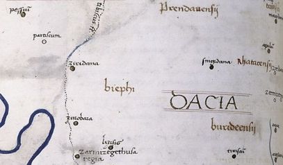
The Timiș or Tamiš ( ro, Timiș, sr, Тамиш; german: Temesch, hu, Temes) is a long river that flows through the Banat region of Romania and Serbia and joins the Danube near Pančevo, in northern Serbia. Due to its position in the region, it has been labeled as the "spine of the Banat". Name In antiquity, the river was known as ''Tibiscus'' (in Latin) and ''Tibisis'' (Θίβισις in ancient Greek); in addition, Edward Gibbon referred to it as the ''Teyss''. ''The Romans, who traversed the plains of Hungary, suppose that they passed several navigable rivers, either in canoes or portable boats; but there is reason to suspect that the winding stream of the Teyss, or Tibiscus, might present itself in different places under different names.'' Geography The drainage area covers , of which in Romania. With the Danube, it belongs to the Black Sea drainage basin. The river flows through Romania for , and through Serbia. Its average discharge at the mouth is . The ... [...More Info...] [...Related Items...] OR: [Wikipedia] [Google] [Baidu] |
HIP-Petrohemija
HIP–Petrohemija ( sr, ХИП-Петрохемија) is a Serbian petrochemical company, with the headquarters in Pančevo, Serbia. The company owns petrochemical complexes located in Pančevo, Elemir and Crepaja. It specializes in producing HDPE, LDPE and other petrochemical products with an annual production capacity of 700,000 tonnes. History Petrohemija was founded in 1968 by the Government of SFR Yugoslavia. On 24 December 2021, Naftna Industrija Srbije increased its stake in HIP-Petrohemija to 90% of shares, after purchasing the majority of stakes from the Government of Serbia for 150 million euros. Activity HIP Petrohemija owns large petrochemical complexes located in Pančevo, Elemir and Crepaja. These complexes include a number of nine producing plants. The ethylene plant is located in Pančevo and was established in 1979 and built by United States based company Stone & Webster and French company French Institute of Petroleum. It produces ethylene, propylene, syn ... [...More Info...] [...Related Items...] OR: [Wikipedia] [Google] [Baidu] |
High School "Nikola Tesla" (Pančevo)
The High School of Electrical Engineering "Nikola Tesla" ( sr-cyrl, Електротехничка школа "Никола Тесла", Elektrotehnička škola "Nikola Tesla"; also abbreviated as ETŠ "Nikola Tesla") is a public vocational high school located in Pančevo, Serbia. It educates and trains students in the field of electrical engineering, computer science and informatics. It is named after Nikola Tesla, a Serbian-American inventor, electrical engineer, mechanical engineer and futurist. History The high school was established in 1946 and was initially located in a building at Lava Tolstoja 30, where the elementary school " Đura Jakšić" is located in present period. In 1948, ETŠ moved into a building at Đura Jakšić 1, a building next to the Catholic church, and it was located there until 1966. That year, ETŠ moved again to a new building at Braća Jovanovića 89, together with the Chemistry High School. Once again, the school moved its address in 1983 to M ... [...More Info...] [...Related Items...] OR: [Wikipedia] [Google] [Baidu] |
South Banat District
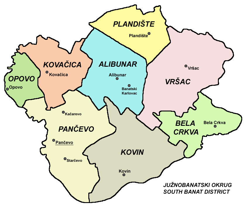
The South Banat District ( sr, Јужнобанатски округ, Južnobanatski okrug, ; hu, Dél-bánsági körzet; ) is one of seven administrative districts of the autonomous province of Vojvodina, Serbia. The administrative center of the district is the city of Pančevo. The district lies in the region of Banat. According to the 2011 census results, it has a population of 291,327 inhabitants. Name In Serbian, the district is known as ''Južnobanatski okrug'' (Јужнобанатски округ), in Croatian as ''Južnobanatski okrug'', in Hungarian as ''Dél-bánsági körzet'', in Slovak as ''Juhobanátsky okres'', in Romanian as ''Districtul Banatul de Sud'', and in Rusyn as /Јужнобанатски окрух/. Municipalities It encompasses the cities of Pančevo and Vršac and the following municipalities: * Plandište * Opovo * Kovačica * Alibunar * Bela Crkva * Kovin Demographics According to the last official census done in 2011, the South B ... [...More Info...] [...Related Items...] OR: [Wikipedia] [Google] [Baidu] |
Banat
Banat (, ; hu, Bánság; sr, Банат, Banat) is a geographical and historical region that straddles Central and Eastern Europe and which is currently divided among three countries: the eastern part lies in western Romania (the counties of Timiș, Caraș-Severin, Arad south of the Mureș river, and the western part of Mehedinți); the western part of Banat is in northeastern Serbia (mostly included in Vojvodina, except for a small part included in the Belgrade Region); and a small northern part lies within southeastern Hungary (Csongrád-Csanád County). The region's historical ethnic diversity was severely affected by the events of World War II. Today, Banat is mostly populated by ethnic Romanians, Serbs and Hungarians, but small populations of other ethnic groups also live in the region. Nearly all are citizens of either Serbia, Romania or Hungary. Name During the Middle Ages, the term " banate" designated a frontier province led by a military governor who was ... [...More Info...] [...Related Items...] OR: [Wikipedia] [Google] [Baidu] |
Utva Aviation Industry
Utva Aviation Industry (commonly known as UTVA) is a Serbian manufacturer of general aviation aircraft, subsidiary of Yugoimport SDPR, headquartered in Pančevo. History Utva was founded on 5 June 1937 in Zemun, since 1940 located in Pančevo, produced simple gliders. In 1939 Utva began manufacturing light piston engine aircraft. During the NATO bombing of Yugoslavia in 1999, the factory was heavily damaged. In 2017, Serbian defence company Yugoimport SDPR Yugoimport–SDPR ( sr, Југоимпорт–СДПР, Jugoimport–SDPR) is a Serbian state-owned weapons manufacturer as well as intermediary company for the import and export of defense-related equipment. It is headquartered in Belgrade, ... became the majority stakeholder of Utva with around 96% of total shares. Products Aircraft Gliders Unmanned aerial vehicles See also * Aero East Europe Sila * Defense industry of Serbia * Aircraft industry of Serbia References Footnotes Notes External l ... [...More Info...] [...Related Items...] OR: [Wikipedia] [Google] [Baidu] |
Territory Of The Military Commander In Serbia
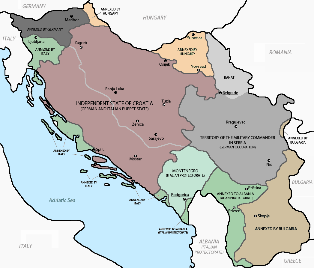
The Territory of the Military Commander in Serbia (german: Gebiet des Militärbefehlshabers in Serbien; sr, Подручје Војног заповедника у Србији, Područje vojnog zapovednika u Srbiji) was the area of the Kingdom of Yugoslavia that was placed under a military government of occupation by the Wehrmacht following the invasion, occupation and dismantling of Yugoslavia in April 1941. The territory included only central Serbia, with the addition of the northern part of Kosovo (around Kosovska Mitrovica), and the Banat. This territory was the only area of partitioned Yugoslavia in which the German occupants established a military government. This was due to the key rail and the Danube transport routes that passed through it, and its valuable resources, particularly non-ferrous metals. On 22 April 1941, the territory was placed under the supreme authority of the German military commander in Serbia, with the day-to-day administration of the territory ... [...More Info...] [...Related Items...] OR: [Wikipedia] [Google] [Baidu] |
Serbia
Serbia (, ; Serbian: , , ), officially the Republic of Serbia (Serbian: , , ), is a landlocked country in Southeastern and Central Europe, situated at the crossroads of the Pannonian Basin and the Balkans. It shares land borders with Hungary to the north, Romania to the northeast, Bulgaria to the southeast, North Macedonia to the south, Croatia and Bosnia and Herzegovina to the west, and Montenegro to the southwest, and claims a border with Albania through the disputed territory of Kosovo. Serbia without Kosovo has about 6.7 million inhabitants, about 8.4 million if Kosvo is included. Its capital Belgrade is also the largest city. Continuously inhabited since the Paleolithic Age, the territory of modern-day Serbia faced Slavic migrations in the 6th century, establishing several regional states in the early Middle Ages at times recognised as tributaries to the Byzantine, Frankish and Hungarian kingdoms. The Serbian Kingdom obtained recognition by the Holy S ... [...More Info...] [...Related Items...] OR: [Wikipedia] [Google] [Baidu] |
Danube
The Danube ( ; ) is a river that was once a long-standing frontier of the Roman Empire and today connects 10 European countries, running through their territories or being a border. Originating in Germany, the Danube flows southeast for , passing through or bordering Austria, Slovakia, Hungary, Croatia, Serbia, Romania, Bulgaria, Moldova, and Ukraine before draining into the Black Sea. Its drainage basin extends into nine more countries. The largest cities on the river are Vienna, Budapest, Belgrade and Bratislava, all of which are the capitals of their respective countries; the Danube passes through four capital cities, more than any other river in the world. Five more capital cities lie in the Danube's basin: Bucharest, Sofia, Zagreb, Ljubljana and Sarajevo. The fourth-largest city in its basin is Munich, the capital of Bavaria, standing on the Isar River. The Danube is the second-longest river in Europe, after the Volga in Russia. It flows through much of Central an ... [...More Info...] [...Related Items...] OR: [Wikipedia] [Google] [Baidu] |
Vojvodina
Vojvodina ( sr-Cyrl, Војводина}), officially the Autonomous Province of Vojvodina, is an autonomous province that occupies the northernmost part of Serbia. It lies within the Pannonian Basin, bordered to the south by the national capital Belgrade and the Sava and Danube Rivers. The administrative center, Novi Sad, is the second-largest city in Serbia. The historic regions of Banat, Bačka, and Syrmia overlap the province. Modern Vojvodina is multi-ethnic and multi-cultural, with some 26 ethnic groups and six official languages. About two million people, nearly 27% of Serbia's population, live in the province. Naming ''Vojvodina'' is also the Serbian word for voivodeship, a type of duchy overseen by a voivode. The Serbian Voivodeship, a precursor to modern Vojvodina, was an Austrian province from 1849 to 1860. Its official name is the Autonomous Province of Vojvodina. Its name in the province's six official languages is: * Croatian: ''Autonomna Pokrajina Vojvodina'' ... [...More Info...] [...Related Items...] OR: [Wikipedia] [Google] [Baidu] |
List Of Cities In Serbia
, plural: ) is elected through popular vote, elected by their citizens in local elections. Also, the presidents of the municipalities are often referred to as "mayors" in everyday usage. There are 29 cities (, singular: ), each having an assembly and budget of its own. As with a municipality, the territory of a city is composed of a city proper and surrounding villages (e.g. the territory of the City of Subotica is composed of the Subotica town and surrounding villages). The capital Belgrade is the only city on the level of a district. All other cities are on the municipality level and are part of a district. ;City municipalities The city may or may not be divided into ''city municipalities''. Five cities (Belgrade, Niš, Požarevac, Vranje and Užice) comprise several city municipalities. Competences of cities and city municipalities are divided. The city municipalities of these six cities also have their assemblies and other prerogatives. The largest city municipality by numbe ... [...More Info...] [...Related Items...] OR: [Wikipedia] [Google] [Baidu] |

