|
Narayangad
Narayangad is a fort in Pune district near to khodad-Gadachiwadi in the Indian state of Maharashtra. Location About three miles east of the town Narayangoan on a detached hill which on the north, south, and west rises sharp from the plain is the dismantled fort of Narayangad. Narayangad is a hill fort near Pune, located 80 km from Pune, 8 km from Narayangaon and 5 km from Khodad village. Near Narayangad is a small village named Gadachiwadi. The name of the taluka- Junnar(Shivaneri fort) Narayagoan is derived from the fort. From the base of the fort to the top of the fort is an easy climbing of twenty minutes. Also the bus available from Narayangaon to khodad from Narayagoan on 7km a bus stop Named as "GADACHWADI". From that point you can enjoy a trek with natural environment. Places to see Above the fort there are small waterponds named Narayantake, and Chambar Take. At the highest point of the fort there is a temple of the Goddess "Hastamata" and below it there is the temple of ... [...More Info...] [...Related Items...] OR: [Wikipedia] [Google] [Baidu] |
Pune District
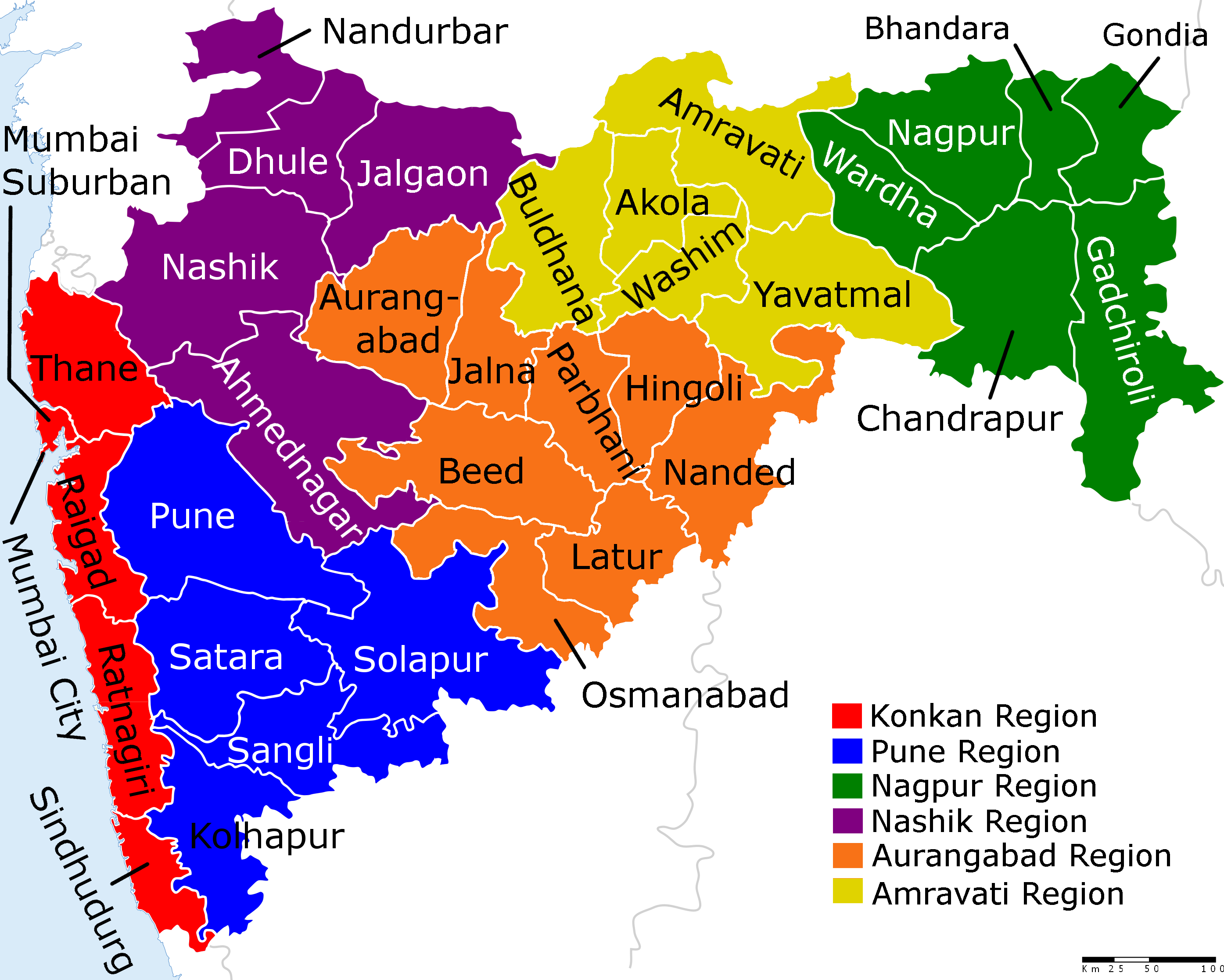
Pune district (Marathi pronunciation: uɳeː is the most populous district in the Indian state of Maharashtra. The district's population was 9,429,408 in the 2011 census, making it the fourth most populous district amongst India's 640 districts. This district has an urban population of 58.08 percent of its total. It is one of the most industrialized districts in India. In recent decades it has also become a hub for information technology. Officer Members of Parliament *Girish Bapat ( BJP) - * Supriya Sule ( NCP) - * Dr. Amol Kolhe ( NCP) - *Shrirang Barne ( BSS) - Guardian Minister list of Guardian Minister District Magistrate/Collector list of District Magistrate / Collector District Justice District Police Commissioner list of District Police Commissioner President & Vice-President Zilla Parishad *President list of President Zilla Parishad Pune *Vice-President list of Vice-President Zilla Parishad Pune Chief Executive Offic ... [...More Info...] [...Related Items...] OR: [Wikipedia] [Google] [Baidu] |
Narayangaon
Narayangaon is a town in the Junnar taluka of the Pune district of Maharashtra state, India. Water is abundant because of its proximity to the major dams, the western ghats, and the Sahyadri mountain range. Geography Narayangaon is located 656 m (2,152 ft) above sea level on the western margin of the Deccan plateau. It is situated on the leeward side of the Sahyadri mountain range, which forms a barrier from the Arabian sea. Narayangaon is on the bank of the river Meena. A wide hill range in the south separates the town from the adjoining Ambegaon taluka. Narayangaon can be reached from major cities via road. It is situated on Pune-Nasik National Highway 50. It is 77 km north of Pune, 132 km south of Nasik and around 176 km east of the state capital, Mumbai. Historic importance Shivneri Fort, the birthplace of Chattrapati Shivaji Maharaj, who founded and ruled the Maratha empire during the 17th century, is 16 km away from Narayangaon. Two of the Asht ... [...More Info...] [...Related Items...] OR: [Wikipedia] [Google] [Baidu] |
Maharashtra
Maharashtra (; , abbr. MH or Maha) is a state in the western peninsular region of India occupying a substantial portion of the Deccan Plateau. Maharashtra is the second-most populous state in India and the second-most populous country subdivision globally. It was formed on 1 May 1960 by splitting the bilingual Bombay State, which had existed since 1956, into majority Marathi-speaking Maharashtra and Gujarati-speaking Gujarat. Maharashtra is home to the Marathi people, the predominant ethno-linguistic group, who speak the Marathi language, the official language of the state. The state is divided into 6 divisions and 36 districts, with the state capital being Mumbai, the most populous urban area in India, and Nagpur serving as the winter capital, which also hosts the winter session of the state legislature. Godavari and Krishna are the two major rivers in the state. Forests cover 16.47 per cent of the state's geographical area. Out of the total cultivable land in the ... [...More Info...] [...Related Items...] OR: [Wikipedia] [Google] [Baidu] |
East India Company
The East India Company (EIC) was an English, and later British, joint-stock company founded in 1600 and dissolved in 1874. It was formed to trade in the Indian Ocean region, initially with the East Indies (the Indian subcontinent and Southeast Asia), and later with East Asia. The company seized control of large parts of the Indian subcontinent, colonised parts of Southeast Asia and Hong Kong. At its peak, the company was the largest corporation in the world. The EIC had its own armed forces in the form of the company's three Presidency armies, totalling about 260,000 soldiers, twice the size of the British army at the time. The operations of the company had a profound effect on the global balance of trade, almost single-handedly reversing the trend of eastward drain of Western bullion, seen since Roman times. Originally chartered as the "Governor and Company of Merchants of London Trading into the East-Indies", the company rose to account for half of the world's trad ... [...More Info...] [...Related Items...] OR: [Wikipedia] [Google] [Baidu] |
British Raj
The British Raj (; from Hindi ''rāj'': kingdom, realm, state, or empire) was the rule of the British Crown on the Indian subcontinent; * * it is also called Crown rule in India, * * * * or Direct rule in India, * Quote: "Mill, who was himself employed by the British East India company from the age of seventeen until the British government assumed direct rule over India in 1858." * * and lasted from 1858 to 1947. * * The region under British control was commonly called India in contemporaneous usage and included areas directly administered by the United Kingdom, which were collectively called British India, and areas ruled by indigenous rulers, but under British paramountcy, called the princely states. The region was sometimes called the Indian Empire, though not officially. As ''India'', it was a founding member of the League of Nations, a participating nation in the Summer Olympics in 1900, 1920, 1928, 1932, and 1936, and a founding member of the United Nations in ... [...More Info...] [...Related Items...] OR: [Wikipedia] [Google] [Baidu] |
India
India, officially the Republic of India (Hindi: ), is a country in South Asia. It is the List of countries and dependencies by area, seventh-largest country by area, the List of countries and dependencies by population, second-most populous country, and the most populous democracy in the world. Bounded by the Indian Ocean on the south, the Arabian Sea on the southwest, and the Bay of Bengal on the southeast, it shares land borders with Pakistan to the west; China, Nepal, and Bhutan to the north; and Bangladesh and Myanmar to the east. In the Indian Ocean, India is in the vicinity of Sri Lanka and the Maldives; its Andaman and Nicobar Islands share a maritime border with Thailand, Myanmar, and Indonesia. Modern humans arrived on the Indian subcontinent from Africa no later than 55,000 years ago., "Y-Chromosome and Mt-DNA data support the colonization of South Asia by modern humans originating in Africa. ... Coalescence dates for most non-European populations average to betwee ... [...More Info...] [...Related Items...] OR: [Wikipedia] [Google] [Baidu] |
Fort
A fortification is a military construction or building designed for the defense of territories in warfare, and is also used to establish rule in a region during peacetime. The term is derived from Latin ''fortis'' ("strong") and ''facere'' ("to make"). From very early history to modern times, defensive walls have often been necessary for cities to survive in an ever-changing world of invasion and conquest. Some settlements in the Indus Valley civilization were the first small cities to be fortified. In ancient Greece, large stone walls had been built in Mycenaean Greece, such as the ancient site of Mycenae (famous for the huge stone blocks of its 'cyclopean' walls). A Greek '' phrourion'' was a fortified collection of buildings used as a military garrison, and is the equivalent of the Roman castellum or English fortress. These constructions mainly served the purpose of a watch tower, to guard certain roads, passes, and borders. Though smaller than a real fortress, they acte ... [...More Info...] [...Related Items...] OR: [Wikipedia] [Google] [Baidu] |
Pune
Pune (; ; also known as Poona, ( the official name from 1818 until 1978) is one of the most important industrial and educational hubs of India, with an estimated population of 7.4 million As of 2021, Pune Metropolitan Region is the largest in Maharashtra by area, with a geographical area of 7,256 sq km. It has been ranked "the most liveable city in India" several times. Pune is also considered to be the cultural and educational capital of Maharashtra. Along with the municipal corporation area of PCMC, PMC and the three cantonment towns of Camp, Khadki, and Dehu Road, Pune forms the urban core of the eponymous Pune Metropolitan Region (PMR). Situated {{convert, 560, m, 0, abbr=off above sea level on the Deccan plateau, on the right bank of the Mutha river,{{cite web , last=Nalawade , first=S.B. , url=http://www.ranwa.org/punealive/pageog.htm , title=Geography of Pune Urban Area , publisher=Ranwa , access-date=4 April 2008 , archive-url=https://web.archive.org/web/200712 ... [...More Info...] [...Related Items...] OR: [Wikipedia] [Google] [Baidu] |
GMRT Project
The Giant Metrewave Radio Telescope (GMRT), located near Pune, Junnar, near Narayangaon at khodad in India, is an array of thirty fully steerable parabolic radio telescopes of 45 metre diameter, observing at metre wavelengths. It is operated by the National Centre for Radio Astrophysics (NCRA), a part of the Tata Institute of Fundamental Research, Mumbai. It was conceived and built under the direction of Late Prof. Govind Swarup during 1984 to 1996. It is an interferometric array with baselines of up to . It was recently upgraded with new receivers, after which it is also known as the Upgraded Giant Metrewave Radio Telescope (uGMRT). Location The GMRT Observatory is located about 80 km north of Pune at Khodad. A nearby town is Narayangaon which is around 9 km from the telescope site. The office of NCRA is located in the Savitribai Phule Pune University campus. Science and observations One of the aims for the telescope during its development was to search for the highly ... [...More Info...] [...Related Items...] OR: [Wikipedia] [Google] [Baidu] |
Satvahana
The Satavahanas (''Sādavāhana'' or ''Sātavāhana'', IAST: ), also referred to as the Andhras in the Puranas, were an ancient Indian dynasty based in the Deccan region. Most modern scholars believe that the Satavahana rule began in the late second century BCE and lasted until the early third century CE, although some assign the beginning of their rule to as early as the 3rd century BCE based on the Puranas, but uncorroborated by archaeological evidence. The Satavahana kingdom mainly comprised the present-day Andhra Pradesh, Telangana, and Maharashtra. At different times, their rule extended to parts of modern Gujarat, Madhya Pradesh, and Karnataka. The dynasty had different capital cities at different times, including Pratishthana (Paithan) and Amaravati ( Dharanikota). The origin of the dynasty is uncertain, but according to the Puranas, their first king overthrew the Kanva dynasty. In the post-Maurya era, the Satavahanas established peace in the Deccan region and resiste ... [...More Info...] [...Related Items...] OR: [Wikipedia] [Google] [Baidu] |


