|
Maienfeld
Maienfeld ( rm, Maiavilla) is a municipality in the Landquart Region in the Swiss canton of Graubünden. It is a tourist destination in the Alps, both because of the local wine and because it was the setting of the story ''Heidi''. History Maienfeld lies along a key route through the Rhine Valley in the Alps. Prehistoric Bronze work and a pre-Roman cellar have been found in the city and on St. Luzisteig hill. A 3rd-century Roman station or settlement has been found along the old Roman Road. The 4th or 5th century Tabula Peutingeriana map shows a place called ''Magia'' near modern Maienfeld. The village is first mentioned in 831 and was known as ''Lupinis'' at that time. The name of the village changed several times over the following centuries and included; ''Magenza'', ''Lopine'', ''Maging'' and ''Magen zu Luppinis''. Finally, in 1295 the name ''Maienvelt'' was used, which eventually became Maienfeld. [...More Info...] [...Related Items...] OR: [Wikipedia] [Google] [Baidu] |
Schloss Brandis
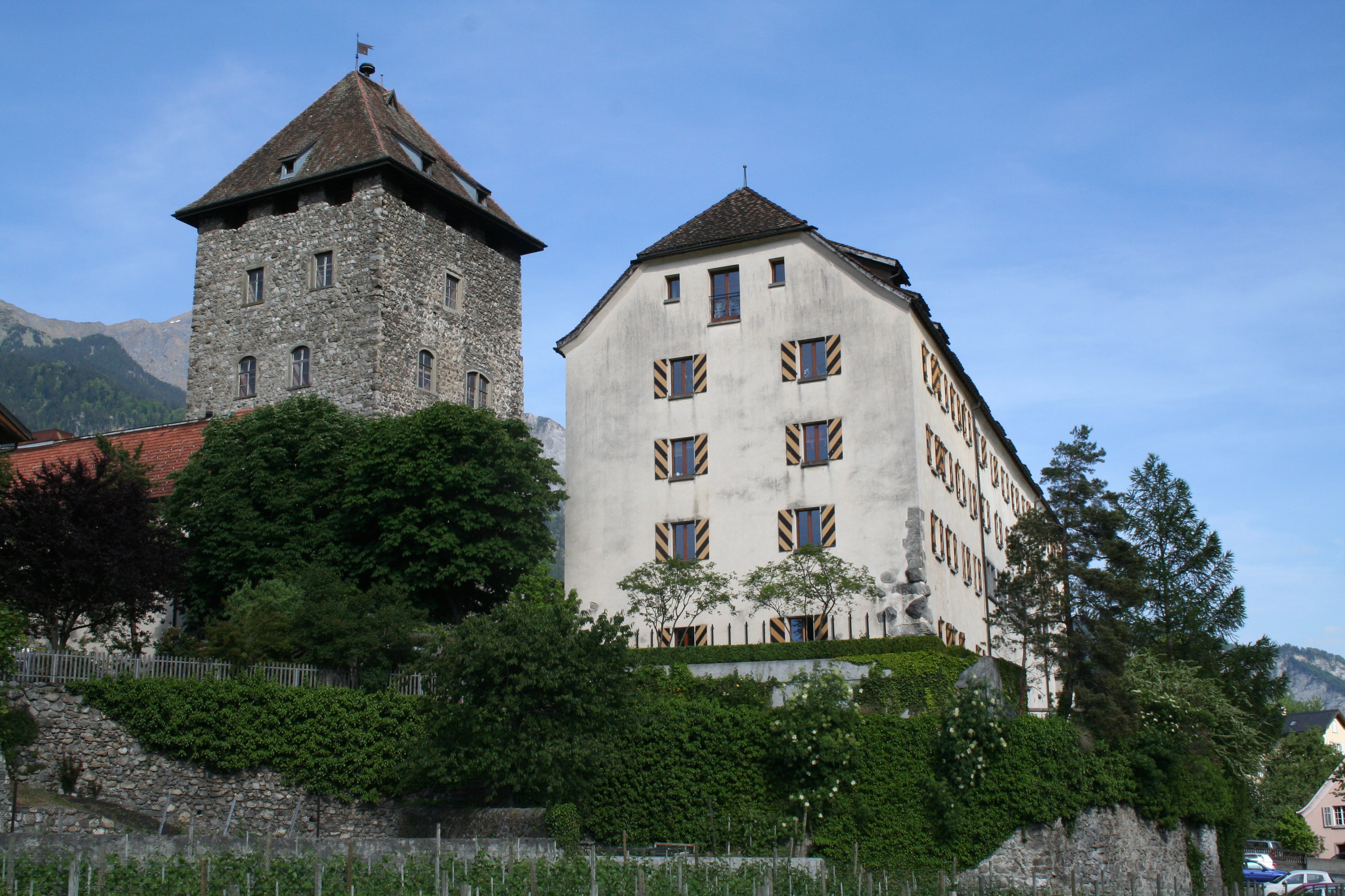
Brandis Castle or Maienfeld Castle is a castle in the municipality of Maienfeld of the Canton of Graubünden in Switzerland. It is a Swiss heritage site of national significance. History The Maienfeld area was an important Roman era customs station on the road between Turicum ( Zurich) and Brigantium (Bregenz). After the Fall of the Western Roman Empire the area probably remained a local population center and retained some of the Roman buildings and fortifications. During the High Middle Ages the Carolingian royal estate of ''curtis Lupinis'' was built in the area and the town of Maienfeld grew up around the castle. In the 10th century the Lords of Bregenz probably built a small fortified tower near or on the site of the current castle. The castle was built in the 13th century for the Freiherr von Aspermont and was originally known as Maienfeld Castle. In 1282 Heinrich von Aspermont specified in his will that upon his death his brother, Egilolf, was to inherit the cas ... [...More Info...] [...Related Items...] OR: [Wikipedia] [Google] [Baidu] |
Heidi
''Heidi'' (; ) is a work of children's fiction published in 1881 by Swiss author Johanna Spyri, originally published in two parts as ''Heidi: Her Years of Wandering and Learning'' (german: Heidis Lehr- und Wanderjahre) and ''Heidi: How She Used What She Learned'' (german: Heidi kann brauchen, was es gelernt hat). It is a novel about the events in the life of a 5-year-old girl in her paternal grandfather's care in the Swiss Alps. It was written as a book "for children and those who love children" (as quoted from its subtitle). ''Heidi'' is one of the best-selling books ever written and is among the best-known works of Swiss literature. Plot Heidi is an orphaned girl initially raised by her maternal grandmother and aunt Dete in Maienfeld, in the Grisons, after the early deaths of her parents, Tobias and Adelheid (Dete's brother-in-law and sister). Shortly after the grandmother's death, Dete is offered a good job as a maid in the big city, and takes 5-year-old Heidi to her pat ... [...More Info...] [...Related Items...] OR: [Wikipedia] [Google] [Baidu] |
Jenins
Jenins ''( Romansh: Gianin)'' is a municipality in the Landquart Region in the Swiss canton of Graubünden. History Jenins is first mentioned in 1139 as ''Uienennes''. In 1142 it was mentioned as ''Gininnes''. Geography Jenins has an area, , of . Of this area, 48% is used for agricultural purposes, while 40.1% is forested. Of the rest of the land, 3.6% is settled (buildings or roads) and the remainder (8.3%) is non-productive (rivers, glaciers or mountains). Before 2017, the municipality was located in the Maienfeld sub-district of the Landquart district, after 2017 it was part of the Landquart Region. Demographics Jenins has a population (as of ) of . , 10.6% of the population was made up of foreign nationals. Over the last 10 years the population has grown at a rate of 8.6%. Most of the population () speaks German (93.8%), with Romansh being second most common ( 1.2%) and English being third ( 0.9%). [...More Info...] [...Related Items...] OR: [Wikipedia] [Google] [Baidu] |
Fläsch
Fläsch is a municipality in the Landquart Region in the Swiss canton of Graubünden. History Fläsch is first mentioned in 831 as ''Villa Flasce''. Painter Anna Barbara Bansi was a native of the town.Profile at the ''Dictionary of Pastellists Before 1800''. Geography Fläsch has an area, , of . Of this area, 35.3% is used for agricultural purposes, while 43.8% is forested. Of the rest of the land, 2% is settled (buildings or roads) and the remainder (18.8%) is non-productive (rivers, glaciers or mountains). Before 2017, the municipality was located in the Maienfeld sub-district of the Landquart district, after 2017 it was part of the Landquart Region. It is the most northerly municipality in the canton of Graubünden. Fläsch is located at the foot of the[...More Info...] [...Related Items...] OR: [Wikipedia] [Google] [Baidu] |
Malans, Switzerland
Malans is a municipality in the Landquart Region in the Swiss canton of Graubünden. History Malans is first mentioned about 840 as ''in villa Mellanze''. In 956 it was mentioned as ''Malanz''. Geography Malans has an area, , of . Of this area, 39.5% is used for agricultural purposes, while 44.4% is forested. Of the rest of the land, 6.9% is settled (buildings or roads) and the remainder (9.2%) is non-productive (rivers, glaciers or mountains). The municipality is the capital of the Maienfeld sub-district of the Landquart district, after 2017 it was part of the Landquart Region. It lies along the old Rhine valley road and the road over the ''Fadärastein'' pass into the Prättigau valley. Demographics Malans has a population (as of ) of . , 7.7% of the population was made up of foreign nationals. Over the last 10 years the population has grown at a rate of 16%. Most of the population () speaks German (94.9%), with Romansh being second most common ( 1.3%) and Itali ... [...More Info...] [...Related Items...] OR: [Wikipedia] [Google] [Baidu] |
Alpine Rhine
The Alpine Rhine Valley (german: Alpenrheintal) is a glacial alpine valley, formed by the part of the Alpine Rhine (german: Alpenrhein ) between the confluence of the Anterior Rhine and Posterior Rhine at Reichenau and the Alpine Rhine's mouth at Lake Constance. It covers three countries and the full length of the Alpine Rhine is 93.5 km. From Reichenau, the Alpine Rhine flows east, passing Chur and turning north, before it turns north-east at Landquart, and then roughly north, east of Sargans. From here, the Alpine Rhine forms the border between the canton of St. Gallen of Switzerland on the left, west side, and the Principality of Liechtenstein on the east side. About further down, the Rhine then meets the Austrian federal state Vorarlberg and finally flows into Lake Constance, south of Lindau (Germany), which is no longer part of the Rhine Valley. The Swiss-Austrian border follows the historical bed of the Rhine, but today the river follows an artificial canal within Aus ... [...More Info...] [...Related Items...] OR: [Wikipedia] [Google] [Baidu] |
Zizers
Zizers ( rm, Zezras) is a municipalities of Switzerland, municipality in the Landquart Region in the Switzerland, Swiss Cantons of Switzerland, canton of Graubünden. Zita of Bourbon-Parma, Empress of Austria-Hungary died in Zizers. History Zizers is first mentioned in 824 as ''Zizuris''. Geography Zizers has an area, (as of the 2004/09 survey) of . Of this area, about 39.1% is used for agricultural purposes, while 38.0% is forested. Of the rest of the land, 14.5% is settled (buildings or roads) and 8.4% is unproductive land. In the 2004/09 survey a total of or about 6.9% of the total area was covered with buildings, an increase of over the 1985 amount. Of the agricultural land, is used for orchards and vineyards and is fields and grasslands. Since 1985 the amount of agricultural land has decreased by . Over the same time period the amount of forested land has increased by . Rivers and lakes cover in the municipality. [...More Info...] [...Related Items...] OR: [Wikipedia] [Google] [Baidu] |
Seewis Im Prättigau
Seewis im Prättigau is a Swiss village in the Prättigau and a municipality in the Prättigau/Davos Region in the canton of Graubünden. History Seewis im Prättigau is first mentioned in 1224 as ''de Sevve''. In 1622, Fidelis of Sigmaringen a Capuchin friar, was martyred in the Counter-Reformation at Seewis. Geography Seewis im Prättigau has an area, , of . Of this area, 41.3% is used for agricultural purposes, while 34% is forested. Of the rest of the land, 2% is settled (buildings or roads) and the remainder (22.6%) is non-productive (rivers, glaciers or mountains). Before 2017, the municipality was located in the Seewis sub-district of the Prättigau/Davos district, after 2017 it was part of the Prättigau/Davos Region. It is located on a terrace on the right valley side at the entrance to the Prättigau valley. It consists of the village of Seewis im Prättigau and the sections of Schmitten-Pardisla and the Seewis-Pardisla railway station on the valley floor. Un ... [...More Info...] [...Related Items...] OR: [Wikipedia] [Google] [Baidu] |
Landquart Region
Landquart Region is one of the eleven administrative districts Administrative division, administrative unit,Article 3(1). country subdivision, administrative region, subnational entity, constituent state, as well as many similar terms, are generic names for geographical areas into which a particular, ind ... in the canton of Graubünden in Switzerland. It had an area of and a population of (as of ).. It was created on 1 January 2017 as part of a reorganization of the Canton. accessed 16 February 2017 References {{C ...[...More Info...] [...Related Items...] OR: [Wikipedia] [Google] [Baidu] |
Mastrils
Mastrils is a former municipality in the district of Landquart in the Swiss canton of Graubünden. The municipalities of Igis and Mastrils merged on 1 January 2012 into the new municipality of Landquart.Amtliches Gemeindeverzeichnis der Schweiz published by the Swiss Federal Statistical Office accessed 21 December 2011 History Mastrils is first mentioned in 1318 as ''Ponstrils''. In 1345 it was mentioned as ''Bastrils''. In 1854 the municipality separated from to become an independent municipality.Geography [...More Info...] [...Related Items...] OR: [Wikipedia] [Google] [Baidu] |
Igis
Igis ''( Romansh: Eigias)'' is a former municipality in the district of Landquart in the Swiss canton of Graubünden. Far better known than its proper name Igis is its hamlet Landquart, because of its Rail Station and motorway exit. The municipalities of Igis and Mastrils merged on 1 January 2012 into the new municipality of Landquart.Amtliches Gemeindeverzeichnis der Schweiz published by the Swiss Federal Statistical Office accessed 21 December 2011 History Igis is first mentioned about 840 as ''Ovinae/Aviuns''. In 1149 it was mentioned as ''Auuine'', in 1225 as ''Huiuns'' and in 1253 as ''Yges''.Geography Igis had an area, , of . Of this area, 44.2% is used for agricultural purposes, while 3 ...[...More Info...] [...Related Items...] OR: [Wikipedia] [Google] [Baidu] |
Bad Ragaz
Bad Ragaz is a municipality in the ''Wahlkreis'' (constituency) of Sarganserland in the canton of St. Gallen in Switzerland. It is the home of a famous natural spring and is a popular spa and health resort destination. History Bad Ragaz is first mentioned ''circa'' 843 as ''Ragaces''. As plain Ragaz, the locality was originally a farming village. It had over the centuries a certain importance owing to its position on the north–south route between Germany and Italy. Its history was closely linked to that of the Benedictine Pfäfers Abbey, an important monastery dating back perhaps to the eighth century, which was the dominant landholder around the village and the principal rights holder. The residence of the Prince Abbot of Pfäfers, a building known as the ''Hof Ragaz'' served as the premises of the local governor or ''Statthalter'', a position exercised by the Abbey. One of the most notable events in the local chronicles is the ''Battle of Ragaz'', an episode in the Old ... [...More Info...] [...Related Items...] OR: [Wikipedia] [Google] [Baidu] |


