|
Khammam District
Khammam district is a district in the eastern region of the Indian state of Telangana. The city of Khammam is the district headquarters. The district shares boundaries with Suryapet, Mahabubabad, Bhadradri districts and with Eluru and NTR districts in Andhra pradesh state. History Paleolithic man probably roamed around the areas of lower Godavari valley and the surroundings of Bhadrachalam, Kothagudem, Wyra, Sathupally and Paloncha Taluks in the district. Prehistoric rock paintings were found near Neeladri konda near Lankapalli of Sathupally Taluk. Megalithic Dolmens were found at Janampet of Pinapaka Taluk. Megalithic site on the campus of Government Degree college in Khammam has yielded pottery and skeletal remains. Kistapuram and Padugonigudem villages in Gundala Taluk of the district were rich in Megalithic cultural remnants explored and discovered recently. The southern parts of Khammam district flourished as famous Buddhist centers along with Amaravathi and Vi ... [...More Info...] [...Related Items...] OR: [Wikipedia] [Google] [Baidu] |
Districts Of Telangana
The Indian state of Telangana has 33 districts, each headed by a District collector. History Telangana region of Hyderabad State consisted of 8 Districts in 1948 when it was inducted in Dominion of India; they are Hyderabad, Mahbubnagar, Medak, Nalgonda, Nizamabad, Adilabad, Karimnagar and Warangal districts. Khammam district was created by bifurcation of Warangal district on 1 October 1953. Andhra Pradesh was formed by merging Telangana region of Hyderabad State and Andhra state on 1 November 1956. Bhadrachalam division and Aswaraopet taluka parts was merged in Khammam district from Godavari districts for better Administration. Hyderabad district was split into Hyderabad Urban District and Hyderabad Rural District on 15 August 1978. Hyderabad Urban District was made by 4 Talukas are Charminar, Golkonda, Mushirabad and Secunderabad Talukas which consist of only MCH area, Secunderabad cantonment and Osmania University. Hyderabad rural district was later renamed as R ... [...More Info...] [...Related Items...] OR: [Wikipedia] [Google] [Baidu] |
NTR District
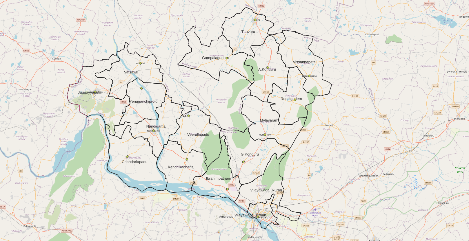
NTR district is a district in coastal Andhra Region in the Indian state of Andhra Pradesh. The administrative headquarters is located at Vijayawada. The district is named after former Chief Minister of Andhra Pradesh N. T. Rama Rao. History Named after former Chief Minister of Andhra Pradesh N. T. Rama Rao, NTR district was proposed on 26 January 2022 and became one of the twenty-six districts in the state after the gazette notification was issued by the Government of Andhra Pradesh on 3 April 2022. The gazette notification came into force on 4 April 2022. The district was carved out of Krishna district, and consists of the existing Vijayawada revenue division along with Nandigama and Tiruvuru revenue divisions, which were formed along with the district. Geography NTR district is bordered with Krishna district and Eluru districts on the East, Palnadu district and Guntur districts on the South, Suryapet district of Telangana state on the West and Khammam district of Tela ... [...More Info...] [...Related Items...] OR: [Wikipedia] [Google] [Baidu] |
Aswaraopeta
Aswaraopeta is a mandal in Bhadradri Kothagudem district, Telangana Telangana (; , ) is a state in India situated on the south-central stretch of the Indian peninsula on the high Deccan Plateau. It is the eleventh-largest state and the twelfth-most populated state in India with a geographical area of and 3 .... Geography Ashwaraopeta is located at . References Mandals in Bhadradri Kothagudem district {{Telangana-geo-stub ... [...More Info...] [...Related Items...] OR: [Wikipedia] [Google] [Baidu] |
Mudigonda
Mudigonda is a town and revenue-divisional headquarters located 14 km from Khammam, the headquarters of the Khammam District of Telangana, India. Introduction Mudigonda is one of the mandal headquarters in Khammam district. It is located along the Khammam-Kodad main road. Mudigonda mandal is surrounded by lot of villages, of which Vallabhi and Bhanapuram are the biggest. The main occupation of the people is agriculture. It is also featured with a rural police station, since it is a politically sensitive mandal. There are huge granite deposits and number of granite mills. Tourist spots at Mudigonda include the Sri Chennakesava and Sri Lakshmi Narasimha Swami temples, Sri Lakshmi Narasimha Swamy Gattu, and the Sri Veera Brahmendhra Swami temples. It was once the capital city of Mudigonda Chalukyas. Villages The villages in Mudigonda mandal includes: Ammapeta, Banapuram, Chirumarri, Gandhasiri, Gokinepalli, Kamalapuram, Kattakoor, New Lakshmipuram, Madhapuram, Mallannapa ... [...More Info...] [...Related Items...] OR: [Wikipedia] [Google] [Baidu] |
Nelakondapalli
Nelakondapally, also referred to as Nelakondapalli or Nela Kondapalli, is a town and headquarters of a mandal in Khammam district, Telangana, India. It is also an archaeological site important to early Buddhism and Hinduism, where excavations have discovered a major stupa site near an ancient manmade lake, another site where Buddhist and Hindu artwork were carved in pre-3rd century India, both sites also yielding hundreds of ancient rare coins with Shaiva and Vaishnava inscriptions from the dynasties of Andhra Ikshvakus and Vishnukundinas. Nelakondapally is also the birthplace of Bhakta Ramadasu.V.V. Krishna Sastry (1990), Recent Trends in Archaeology of Andhra Pradesh, Proceedings of the Indian History Congress, Vol. 51, pp. 771-772, Location Nelakondapalli is located 21 kilometers southwest of Khammam, 58 km east-southeast of Suryapet and close to the Telangana–Andhra Pradesh border. It is connected to the Indian national highway grid with NH365A, the link between Khammam ... [...More Info...] [...Related Items...] OR: [Wikipedia] [Google] [Baidu] |
Munneru
Munneru is a left tributary of the Krishna River. It originates in Warangal District of Telangana, India and flows in the districts of Khammam District and Krishna District. The river is named after Rishi Maudgalya, who is said to have created this river with his spiritual power and performed a penance ritual in Khammam. Origins It originates near Mahabubabad town of Warangal District, Telangana. Flow It flows through Dornakal Eru and comes via Kamanchkal to Danavaigudam suburb of Khammam city where it has a small Dam in order to facilitate water collection. Munneru acts as a water source to Khammam city. It goes through ManchiKanti Nagar, Kalavoddu, Moti Nagar, Prakash Nagar and Dhamsalampuram suburbs of Khammam city. It reaches Chinna Mandava and Lingala villages of Krishna District. It flows into Penuganchiprolu town, Keesara village and finally discharges into the Krishna river at Eturu village near Nandigama downstream of Pulichintala dam. Muniyeru barrage was c ... [...More Info...] [...Related Items...] OR: [Wikipedia] [Google] [Baidu] |
The Hindu
''The Hindu'' is an Indian English-language daily newspaper owned by The Hindu Group, headquartered in Chennai, Tamil Nadu. It began as a weekly in 1878 and became a daily in 1889. It is one of the Indian newspapers of record and the second most circulated English-language newspaper in India, after '' The Times of India''. , ''The Hindu'' is published from 21 locations across 11 states of India. ''The Hindu'' has been a family-owned newspaper since 1905, when it was purchased by S. Kasturi Ranga Iyengar from the original founders. It is now jointly owned by Iyengar's descendants, referred to as the "Kasturi family", who serve as the directors of the holding company. The current chairperson of the group is Malini Parthasarathy, a great-granddaughter of Iyengar. Except for a period of about two years, when Siddharth Varadarajan, S. Varadarajan held the editorship of the newspaper, the editorial positions of the paper were always held by members of the family or held under t ... [...More Info...] [...Related Items...] OR: [Wikipedia] [Google] [Baidu] |
Paloncha
Palwancha is a town in Bhadradri district of the Indian state of Telangana. It is located in Palwancha mandal of Kothagudem revenue division. Demographics Palwancha is a Municipality city in district of Bhadradri district , Telangana . The Palwancha city is divided into 39 wards for which elections are held every 5 years. The Palwancha Municipality has population of 130,199 of which 49,923 are males while 50,276 are females as per report released by Census India 2014. Population of Children with age of 0-6 is 12207 which is 10.23% of total population of Palwancha (M). In Palwancha Municipality, Female Sex Ratio is of 1009 against state average of 993. Moreover Child Sex Ratio in Palwancha is around 970 compared to Andhra Pradesh state average of 939. Literacy rate of Palwancha city is 77.70% higher than state average of 67.02%. In Palwancha, Male literacy is around 84.41% while female literacy rate is 71.09%. Palwancha Municipality has total administration over 20,782 house ... [...More Info...] [...Related Items...] OR: [Wikipedia] [Google] [Baidu] |
Sathupally
Sathupalli is a town in Khammam district of the Indian state of Telangana. It is a Municipality in Sathupally mandal of Khammam revenue division. It is situated approximately east of Hyderabad, from Khammam and from Warangal. It is about north of Amaravati, the state capital of Andhra Pradesh, and west of Rajahmundry. Geography Sathupally is located at on the Global Positioning System. Demographics census of India, Sathupalli Nagar panchayat had a population of 98,615 of which 45,257 were male and 45,319 female with a sex ratio of 1019 against state average of 993. Child population (0–6 years) stands 3145 which is 9.87% of total population with a sex ratio of 1033 compared to 933 of state. Literacy rate stands at 82.37. Governance The present member of legislative assembly is the Telangana Rashtra Samiti. Other political parties include the Telangana Rashtra Samithi, the Indian National Congress, the Bharatiya Janata Party, the CPI, and the CPI(M). The Telan ... [...More Info...] [...Related Items...] OR: [Wikipedia] [Google] [Baidu] |
Wyra
Wyra is a municipal council, town and mandal headquarters in Khammam district of Telangana, India.First Municipal chairman of wyra is Mr.Suthakani.Jaipal . The nearest city is Khammam. The nearest railway station is Khammam. The nearest airport is Vijayawada airport. There is one movie theatre – Vasavi Theatre. The present MLA of Wyra constituency is Lavudya Ramulu Nayak. This town is a Municipal council. The town is the main joint for Madhira, Khammam, Sathupally, Kothagudem and Tallada. Wyra Reservoir is a tourist attraction in Khammam district. The nearest bus station is TSRTC Wyra Bus Station. The assembly constituency contains Konijerla, Karepalli, Julurpadu, Enkoor and Wyra. Wyra was a revenue mandal of Khammam Khammam formally (Khammam Mettu) is the city in Khammam district of the Indian state of Telangana. It is the fourth largest city in the state. It is the headquarters of the Khammam district and Khammam Tehsil, mandal also. It is located about ... revenue ... [...More Info...] [...Related Items...] OR: [Wikipedia] [Google] [Baidu] |
Kothagudem
Kothagudem is a City in Telangana. It serves as the headquarters of the Bhadradri Kothagudem district of the Indian state of Telangana Telangana (; , ) is a state in India situated on the south-central stretch of the Indian peninsula on the high Deccan Plateau. It is the eleventh-largest state and the twelfth-most populated state in India with a geographical area of and 35 .... It was a portion of large Zamindari estate known as Husanabad Shankaragiri or Palvancha Zamindari in the Nizam's Dominion. Estate name was given by Captain Glasfurd. The Zamindar of Bhadrachalam was Zamindar of Palvancha also. Geography Kothagudem is located at . It has an average elevation of 89 metres (295 ft) above sea level. The North of Kothagudem borders Chhattisgarh state which is approximately 120 km from the town. Kothagudem is known for its record high temperatures during summer, often crossing mark. Climate Government and politics Kothagudem Municipality was c ... [...More Info...] [...Related Items...] OR: [Wikipedia] [Google] [Baidu] |
Bhadrachalam
Bhadrachalam is a census town in Bhadradri Kothagudem district in the Indian state of Telangana. It is an important Hindu pilgrimage town with the Bhadrachalam Temple of Lord Rama, situated on the banks of Godavari river. It is located east of state capital, Hyderabad, from Khammam, from Warangal, from the Andhra Pradesh state capital Amaravathi and from Visakhapatnam. History The town has a documented history of Lord Sri Rama temple constructed circa 17th century CE by Kancherla Gopanna. Gopanna (1620 - 1680), popularly known as Bhadradri Ramadasu or Bhadrachala Ramadasu, was a 17th-century Indian devotee of Rama and a composer of Carnatic music. His devotional lyrics to Rama are famous in South Indian classical music as Ramadaasu Keertanalu, and have made Bhadrachalam a place of religious importance for Hindus. Bhadrachalam area also has several Hindu temples connected with epic Ramayana. It is referred as "Dakshina Saketa Puri" in the movie "Sri Ramadasu". Geogra ... [...More Info...] [...Related Items...] OR: [Wikipedia] [Google] [Baidu] |


