|
Karaköy
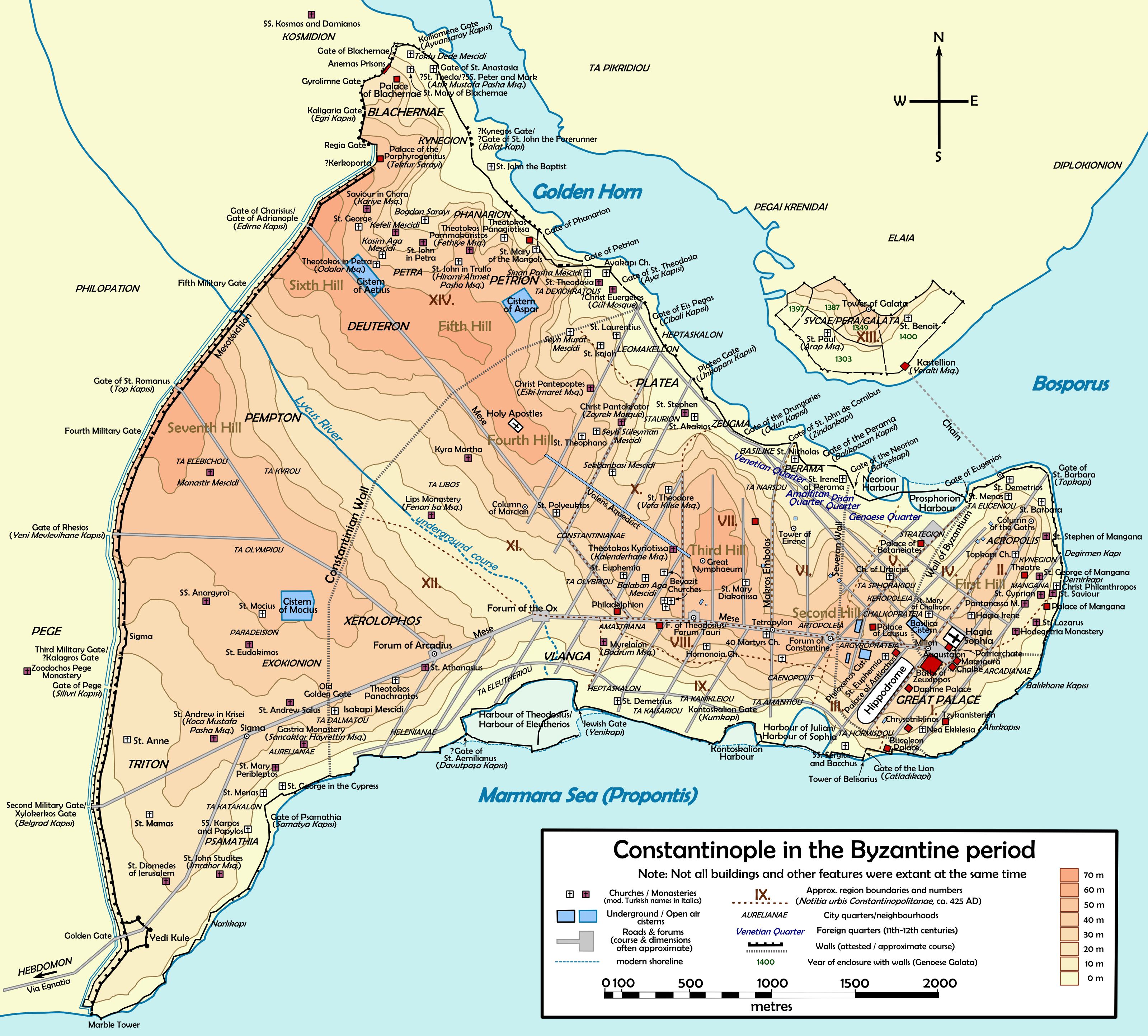
Karaköy (), the modern name for the old Galata, is a commercial quarter in the Beyoğlu district of Istanbul, Turkey, located at the northern part of the Golden Horn mouth on the European side of Bosphorus. Karaköy is one of the oldest and most historic districts of the city, and is today an important commercial center and transport hub. It is connected with the surrounding neighborhoods by streets radiating out from Karaköy Square. The Galata Bridge links Karaköy to Eminönü to the southwest, Tersane Street links it to Azapkapı to the west, Voyvoda Street (Bankalar Caddesi) links it to Şişhane to the northwest, the steeply sloping Yüksek Kaldırım Street links it to Pera in the north, and Kemeraltı Street and Necatibey Street link it to Tophane to the northeast. The commercial quarter, which was originally the meeting place for banks and insurance companies in the 19th century, is today also home to mechanical, electrical, plumbing and electronic parts suppliers ... [...More Info...] [...Related Items...] OR: [Wikipedia] [Google] [Baidu] |
Karaköy Square
Karaköy Square is an area in Karaköy at the north end of the Galata Bridge on the northern bank of the Golden Horn The Golden Horn ( tr, Altın Boynuz or ''Haliç''; grc, Χρυσόκερας, ''Chrysókeras''; la, Sinus Ceratinus) is a major urban waterway and the primary inlet of the Bosphorus in Istanbul, Turkey. As a natural estuary that connects with t .... It is between the opposing directions of the Kemeraltı Street which temporarily splits at Karaköy Square. The metro stop on a part of the square is called Karaköy Station. Sources * * Squares in Istanbul Beyoğlu {{Istanbul-geo-stub ... [...More Info...] [...Related Items...] OR: [Wikipedia] [Google] [Baidu] |
Galata
Galata is the former name of the Karaköy neighbourhood in Istanbul, which is located at the northern shore of the Golden Horn. The district is connected to the historic Fatih district by several bridges that cross the Golden Horn, most notably the Galata Bridge. The medieval citadel of Galata was a colony of the Republic of Genoa between 1273 and 1453. The famous Galata Tower was built by the Genoese in 1348 at the northernmost and highest point of the citadel. Galata is now a quarter within the district of Beyoğlu in Istanbul. Etymology There are several theories concerning the origin of the name ''Galata''. The Greeks believe that the name comes either from ''Galatai'' (meaning "Gauls"), as the Celtic tribe of Gauls ( Galatians) were thought to have camped here during the Hellenistic period before settling into Galatia in central Anatolia; or from ''galatas'' (meaning " milkman"), as the area was used by shepherds for grazing in the Early Medieval (Byzantine) peri ... [...More Info...] [...Related Items...] OR: [Wikipedia] [Google] [Baidu] |
Beyoğlu
Beyoğlu (, ota, بكاوغلی, script=Arab) is a district on the European side of İstanbul, Turkey, separated from the old city (historic peninsula of Constantinople) by the Golden Horn. It was known as the region of Pera (Πέρα, meaning "Beyond" in Greek) surrounding the ancient coastal town Galata which faced Constantinople across the Horn. Beyoğlu continued to be named Pera during the Middle Ages and, in western languages, into the early 20th century. According to the prevailing theory, the Turkish name of Pera, ''Beyoğlu'', is a modification by folk etymology of the Venetian title of ''Bailo'', whose mansion was the grandest structure in this quarter. The informal Turkish-language title ''Bey Oğlu'' (literally ''Son of a Bey'') was originally used by the Ottoman Turks to describe Lodovico Gritti, Istanbul-born son of Andrea Gritti, who was the Venetian Bailo of Constantinople during the reign of Sultan Bayezid II (r. 1481–1512) and was later elected Dog ... [...More Info...] [...Related Items...] OR: [Wikipedia] [Google] [Baidu] |
Istanbul Province
) , postal_code_type = Postal code , postal_code = 34000 to 34990 , area_code = +90 212 (European side) +90 216 (Asian side) , registration_plate = 34 , blank_name_sec2 = GeoTLD , blank_info_sec2 = .ist, .istanbul , website = , blank_name = GDP (Nominal) , blank_info = 2021 , blank1_name = - Total , blank1_info = US$ 248 billion , blank2_name = - Per capita , blank2_info = US$ 15,666 , blank3_name = HDI (2019) , blank3_info = 0.846 () · 1st , timezone = TRT , utc_offset = +3 , module = , name = , government_type = Mayor–council government , governing_body = Municipal Council of Istanbul , image_shield = , established_date = 11 May 330 AD , image_m ... [...More Info...] [...Related Items...] OR: [Wikipedia] [Google] [Baidu] |
Golden Horn
The Golden Horn ( tr, Altın Boynuz or ''Haliç''; grc, Χρυσόκερας, ''Chrysókeras''; la, Sinus Ceratinus) is a major urban waterway and the primary inlet of the Bosphorus in Istanbul, Turkey. As a natural estuary that connects with the Bosphorus Strait at the point where the strait meets the Sea of Marmara, the waters of the Golden Horn help define the northern boundary of the peninsula constituting "Old Istanbul" (ancient Byzantium and Constantinople), the tip of which is the promontory of Sarayburnu, or Seraglio Point. This estuarial inlet geographically separates the historic center of Istanbul from the rest of the city, and forms a horn-shaped, sheltered harbor that in the course of history has protected Greek, Roman, Byzantine, Ottoman and other maritime trade ships for thousandsBBC: "Istanbul ... [...More Info...] [...Related Items...] OR: [Wikipedia] [Google] [Baidu] |
Istanbul
) , postal_code_type = Postal code , postal_code = 34000 to 34990 , area_code = +90 212 (European side) +90 216 (Asian side) , registration_plate = 34 , blank_name_sec2 = GeoTLD , blank_info_sec2 = .ist, .istanbul , website = , blank_name = GDP (Nominal) , blank_info = 2021 , blank1_name = - Total , blank1_info = US$ 248 billion , blank2_name = - Per capita , blank2_info = US$ 15,666 , blank3_name = HDI (2019) , blank3_info = 0.846 () · 1st , timezone = TRT , utc_offset = +3 , module = , name = , government_type = Mayor–council government , governing_body = Municipal Council of Istanbul , image_shield = , established_date = 11 May 330 AD , im ... [...More Info...] [...Related Items...] OR: [Wikipedia] [Google] [Baidu] |
Galata Bridge
The Galata Bridge ( tr, Galata Köprüsü, ) is a bridge that spans the Golden Horn in Istanbul, Turkey. From the end of the 19th century in particular, the bridge has featured in Turkish literature, theater, poetry and novels. The current Galata Bridge is just the latest in a series of bridges linking Eminönü in the Fatih district and Karaköy in Beyoğlu since the early 19th century. The current bridge, the fifth on the same site, was built in 1994. The bridge was named after Galata (the former name for Karaköy) on the northern shore of the Golden Horn. History of Bridging the Golden Horn The first recorded bridge over the Golden Horn was built during the reign of Justinian the Great in the 6th century, close to the area near the Theodosian Land Walls at the western end of the city. In 1453, before the Fall of Constantinople, the Turks assembled a mobile bridge by placing their ships side by side across the water, so that their troops could move from one side of th ... [...More Info...] [...Related Items...] OR: [Wikipedia] [Google] [Baidu] |
Eminönü
Eminönü is a predominantly commercial waterfront area of Istanbul within the Fatih district near the confluence of the Golden Horn with the southern entrance of the Bosphorus strait and the Sea of Marmara. It is connected to Karaköy (historic Galata) via the Galata Bridge across the Golden Horn. It was administered as part of the Sultanahmet district from 1928 to 2009 when Sultanahmet was absorbed into Fatih. Eminönü's busy main square is overlooked by the New Mosque (Yeni Cami in Turkish) and the Spice Bazaar (Mısır Çarşısı in Turkish). Eminönü is an important transport hub. Several ferries have terminals along the Eminönü waterfront and the T1 tram has a stop here. To the southeast Eminönü runs into Sirkeci, while to the northwest it merges with the shopping areas of Tahtakale and Küçükpazar. Inland from Emiõnü is another shopping district, Mahmutpaşa. In Turkish, Eminönü means 'in front of justice' ('emin' meaning 'justice' and 'önü' meaning ... [...More Info...] [...Related Items...] OR: [Wikipedia] [Google] [Baidu] |
Republic Of Genoa
The Republic of Genoa ( lij, Repúbrica de Zêna ; it, Repubblica di Genova; la, Res Publica Ianuensis) was a medieval and early modern maritime republic from the 11th century to 1797 in Liguria on the northwestern Italian coast. During the Late Middle Ages, it was a major commercial power in both the Mediterranean Sea and the Black Sea. Between the 16th and 17th centuries it was one of the major financial centers in Europe. Throughout its history, the Genoese Republic established numerous colonies throughout the Mediterranean and the Black Sea, including Corsica from 1347 to 1768, Monaco, Southern Crimea from 1266 to 1475 and the islands of Lesbos and Chios from the 14th century to 1462 and 1566 respectively. With the arrival of the early modern period, the Republic had lost many of its colonies, and had to shift its interests and focus on banking. This decision would prove successful for Genoa, which remained as one of the hubs of capitalism, with highly developed banks ... [...More Info...] [...Related Items...] OR: [Wikipedia] [Google] [Baidu] |
Bosphorus
The Bosporus Strait (; grc, Βόσπορος ; tr, İstanbul Boğazı 'Istanbul strait', colloquially ''Boğaz'') or Bosphorus Strait is a natural strait and an internationally significant waterway located in Istanbul in northwestern Turkey. It forms part of the continental boundary between Asia and Europe, and divides Turkey by separating Anatolia from Thrace. It is the world's narrowest strait used for international navigation. Most of the shores of the Bosporus Strait, except for the area to the north, are heavily settled, with the city of Istanbul's metropolitan population of 17 million inhabitants extending inland from both banks. The Bosporus Strait and the Dardanelles Strait at the opposite end of the Sea of Marmara are together known as the Turkish Straits. Sections of the shore of the Bosporus in Istanbul have been reinforced with concrete or rubble and those sections of the Strait prone to deposition are periodically dredged. Name The name of the ... [...More Info...] [...Related Items...] OR: [Wikipedia] [Google] [Baidu] |
Tophane
Tophane () is a quarter in the Beyoğlu district of Istanbul, Turkey, running downhill from Galata to the shore of the Bosphorus where it joins up with Karaköy to the southwest and Fındıklı to the northeast. In the Ottoman era, it was the city's first industrial zone. Despite rapid gentrification, parts of Tophane remain conservative and there have been clashes over some developments in the area. In 2021 the large new Galataport cruise terminal opened at the point where Tophane reaches the shore, bringing the likelihood of even faster change to the area. History Tophane acquired its name from the Tophane-i Amire armory ( ota, طوپخانه امیری; en, Imperial armory), which was first built in the reign (1451–1481) of the Ottoman Sultan Mehmed II. Its main purpose was the manufacture of cannons and cannonballs. It appears in an engraving by Antoine Melling (1763–1831). The foundry was built on the site of the lost churches of St Claire and Aya Photi ... [...More Info...] [...Related Items...] OR: [Wikipedia] [Google] [Baidu] |
Eastern European Summer Time
Eastern European Summer Time (EEST) is one of the names of the UTC+03:00 time zone, which is 3 hours ahead of Coordinated Universal Time. It is used as a summer daylight saving time in some European and Middle Eastern countries, which makes it the same as Arabia Standard Time, East Africa Time, and Moscow Time. During the winter periods, Eastern European Time ( UTC+02:00) is used. Since 1996, European Summer Time has been applied from the last Sunday in March to the last Sunday in October. Previously, the rules were not uniform across the European Union. Usage The following countries and territories use Eastern European Summer Time during the summer: * Belarus, Moscow Summer Time in years 1981–89, regular EEST from 1991-2011 * Bulgaria, regular EEST since 1979 * Cyprus, regular EEST since 1979 ( Northern Cyprus stopped using EEST in September 2016, but returned to EEST in March 2018) * Estonia, Moscow Summer Time in years 1981–88, regular EEST since 1989 * Finland, r ... [...More Info...] [...Related Items...] OR: [Wikipedia] [Google] [Baidu] |


