|
Ivano-Frankivsk
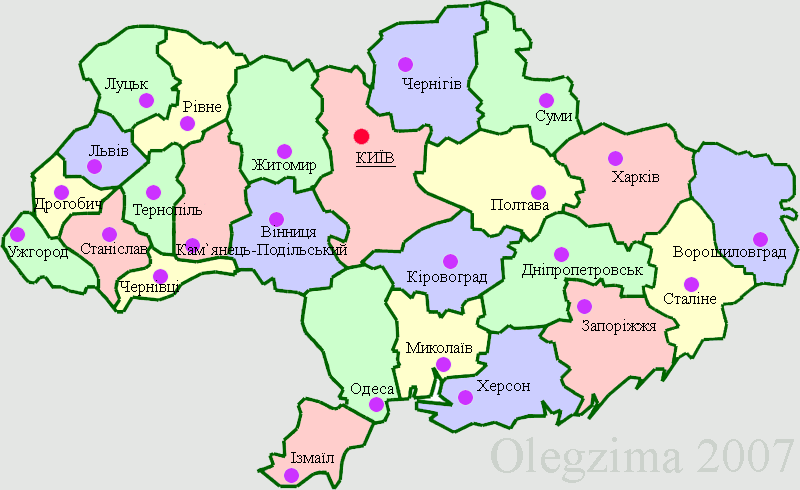
Ivano-Frankivsk ( uk, Іва́но-Франкі́вськ, translit=Iváno-Frankívśk ), formerly Stanyslaviv ( pl, Stanisławów ; german: Stanislau), is a city located in Western Ukraine. It is the administrative centre of Ivano-Frankivsk Oblast and Ivano-Frankivsk Raion. Ivano-Frankivsk hosts the administration of Ivano-Frankivsk urban hromada. Its population is Built in the mid-17th century as a fortress of the Polish Potocki family, Stanisławów was annexed to the Habsburg Empire during the First Partition of Poland in 1772, after which it became the property of the State within the Austrian Empire. The fortress was slowly transformed into one of the most prominent cities at the foothills of the Carpathian Mountains. After World War I, for several months, it served as a temporary capital of the West Ukrainian People's Republic. Following the Peace of Riga in 1921, Stanisławów became part of the Second Polish Republic. After the Soviet invasion of Poland at the on ... [...More Info...] [...Related Items...] OR: [Wikipedia] [Google] [Baidu] |
Ivano-Frankivsk Oblast
Ivano-Frankivsk Oblast ( uk, Іва́но-Франкі́вська о́бласть, translit=Ivano-Frankivska oblast), also referred to as Ivano-Frankivshchyna ( uk, Іва́но-Франкі́вщина), is an oblast (region) in western Ukraine. Its administrative center is the city of Ivano-Frankivsk. As is the case with most other oblasts of Ukraine this region has the same name as its administrative center – which was renamed by the Soviet Ukrainian authorities after the Ukrainian writer Ivan Franko on 9 November 1962. It has a population of Ivano-Frankivsk Oblast is also known to Ukrainians by a deep-rooted alternative name: '' Prykarpattia'' (although some sources may also consider the southern Lviv Oblast including such cities as Stryi, Truskavets, and Drohobych, as also part of Prykarpattia). Prykarpattia, together with Lviv and Ternopil regions, was the main body of the historic region of eastern Halychyna; which in the 13th century was a part of the Kingdom of ... [...More Info...] [...Related Items...] OR: [Wikipedia] [Google] [Baidu] |
Ivano-Frankivsk Raion
Ivano-Frankivsk Raion ( uk, Івано-Франківський район, translit=Ivano-Frankiwśkyj rajon) is a raion (district) of Ivano-Frankivsk Oblast, Ukraine. It was created in July 2020 as part of the reform of administrative divisions of Ukraine. The center of the raion is the city of Ivano-Frankivsk. Five abolished raions, Bohorodchany, Halych, Rohatyn, Tlumach, and Tysmenytsia Raions, as well as Ivano-Frankivsk and Burshtyn Municipalities, were merged into Ivano-Frankivsk Raion. Population: Subdivisions At the time of establishment, the raion consisted of 20 hromadas: * Bilshivtsi settlement hromada with the administration in the urban-type settlement of Bilshivtsi, transferred from Halych Raion; * Bohorodchany settlement hromada with the administration in the urban-type settlement of Bohorodchany, transferred from Bohorodchany Raion; * Bukachivtsi settlement hromada with the administration in the urban-type settlement of Bukachivtsi, transferred from Rohat ... [...More Info...] [...Related Items...] OR: [Wikipedia] [Google] [Baidu] |
List Of Mayors Of Ivano-Frankivsk
Ivano-Frankivsk ( uk, Івано-Франківськ, ''Ivano-Frankivs'k''; pl, Iwano-Frankowsk; german: Iwano-Frankiwsk; russian: Івано-Франкoвск, translit=Ivano-Frankovsk, see also other names) is an administrative center in western Ukraine with almost 350 years of history as a city settlement. For most of its history the city was known by the Polish name of Stanisławów (Stanislaviv). In the Soviet period, it was decided to change the name of the city during its 300th Anniversary in 1962. The local population sometimes refers to it as Frankivsk or even Franyk. History Establishment (Andrzej na Potoky) The city, named Stanisławów (''Stanyslaviv''), was erected as a fortress to protect the Polish-Lithuanian Commonwealth from Tatar invasions and to reinforce the region in case of some other Khmelnytsky Uprising would occur. It was built out of a fort that was erected next to the villages of Zabolotiv which had been known since 1435 and Knyahynyn (1449). The v ... [...More Info...] [...Related Items...] OR: [Wikipedia] [Google] [Baidu] |
Ratusha (Ivano-Frankivsk)
Ratusha, Ivano-Frankivsk ( uk, Івано-Франківська ратуша, pl, Ratusz) is a several stories-tall building in the downtown (Old Town) of the city of Ivano-Frankivsk which formerly served as the town hall (''Rathaus'' in German and ratusz in Polish, hence the name) and now houses the Ivano-Frankivsk Regional History, Crafts and Culture Museum and an observation deck. It is located in the center, at the city's Market Square (Ploshcha Rynok in Ukrainian). It is the only town hall in Ukraine built in the Art Deco style (part of the '' Modern Style''). The current design was created in the 1920s by Polish architect Stanisław Trela, while the original building was built when the city was founded, in the 17th century. The building is constructed such that from a top view it is reminiscent of the Polish order of Virtuti Militari (Military Valor). History First couple of designs At the beginning the ratusz in Stanisławów was erected in the middle of a fortress ... [...More Info...] [...Related Items...] OR: [Wikipedia] [Google] [Baidu] |
Oblasts Of Ukraine
An oblast ( uk, о́бласть; ) in Ukraine, often called a region or province, is the main type of first-level administrative division of the country. Ukraine's territory is divided into 24 oblasts, as well as one autonomous republic, Crimea, and two cities with special status, Kyiv and Sevastopol. Ukraine is a unitary state, thus the oblasts do not have much legal scope of competence other than that which is established in the Ukrainian Constitution and by law. Articles 140–146 of Chapter XI of the constitution deal directly with local authorities and their competency. Oblasts are subdivided into raions (districts), each oblast having from 3 to 10 raions following the July 2020 reform. General characteristics In Ukraine, the term ''oblast'' denotes a primary administrative division. Under the Russian Empire and into the 1920s, Ukraine was divided between several governorates. The term ''oblast'' was introduced in 1932 by Soviet authorities when the Ukrainian SSR wa ... [...More Info...] [...Related Items...] OR: [Wikipedia] [Google] [Baidu] |
West Ukrainian People's Republic
The West Ukrainian People's Republic (WUPR) or West Ukrainian National Republic (WUNR), known for part of its existence as the Western Oblast of the Ukrainian People's Republic, was a short-lived polity that controlled most of Eastern Galicia from November 1918 to July 1919. It included the cities of Lviv, Ternopil, Kolomyia, Drohobych, Boryslav, Stanislaviv (now Ivano-Frankivsk) and right-bank Przemyśl, and claimed parts of Bukovina and Carpathian Ruthenia. Politically, the Ukrainian National Democratic Party (the precursor of the interwar Ukrainian National Democratic Alliance) dominated the legislative assembly, guided by varying degrees of Greek Catholic, liberal and socialist ideology. Other parties represented included the Ukrainian Radical Party and the Christian Social Party. The WUPR emerged as a breakaway state amid the dissolution of Austria-Hungary, and in January 1919 nominally united with the Ukrainian People's Republic (UPR) as its autonomous Western Ob ... [...More Info...] [...Related Items...] OR: [Wikipedia] [Google] [Baidu] |
Svoboda (party)
The All-Ukrainian Union "Freedom" ( uk, Всеукраїнське об'єднання «Свобода», translit=Vseukrainske obiednannia "Svoboda"), commonly known as Svoboda, is an ultranationalist political party in Ukraine. It has been led by Oleh Tyahnybok since 2004. It formed and officially registered as a political party in October 1995. It was characterized as a radical right-wing populist party that combined elements of ethnic ultranationalism and anti-communism. During the 1990s, it was accused of neo-Nazism due to the party's recruitment of skinheads and usage of neo-Nazi symbols.Andrusechko, P. Road of Tyahnybok towards Freedom'. "Ukrayinsky zhurnal". Poznan, May 2009 Tyahnybok was elected in 2004 as the president of the party and shortly after he made efforts to moderate the party's image by changing the party's name and symbols and expelling neo-Nazi and neofascist groups. Although Tyahnybok expelled neofascist groups from his party, it never abandoned ... [...More Info...] [...Related Items...] OR: [Wikipedia] [Google] [Baidu] |
Dissolution Of The Soviet Union
The dissolution of the Soviet Union, also negatively connoted as rus, Разва́л Сове́тского Сою́за, r=Razvál Sovétskogo Soyúza, ''Ruining of the Soviet Union''. was the process of internal disintegration within the Soviet Union (USSR) which resulted in the end of the country's and its federal government's existence as a sovereign state, thereby resulting in its constituent republics gaining full sovereignty on 26 December 1991. It brought an end to General Secretary Mikhail Gorbachev's (later also President) effort to reform the Soviet political and economic system in an attempt to stop a period of political stalemate and economic backslide. The Soviet Union had experienced internal stagnation and ethnic separatism. Although highly centralized until its final years, the country was made up of fifteen top-level republics that served as homelands for different ethnicities. By late 1991, amid a catastrophic political crisis, with several republics alr ... [...More Info...] [...Related Items...] OR: [Wikipedia] [Google] [Baidu] |
West Ukraine
Western Ukraine or West Ukraine ( uk, Західна Україна, Zakhidna Ukraina or , ) is the territory of Ukraine linked to the former Kingdom of Galicia–Volhynia, which was part of the Polish–Lithuanian Commonwealth, the Austrian Empire, Austria-Hungary and the Second Polish Republic, and came fully under the control of the Soviet Union (via the Ukrainian Soviet Socialist Republic) only in 1939, following the Molotov–Ribbentrop Pact. There is no universally accepted definition of the territory's boundaries (see the map, right), but the contemporary Ukrainian administrative regions or Oblasts of Chernivtsi, Ivano-Frankovsk, Lviv, Ternopil and Transcarpathia (which were part of the former Austro-Hungarian Empire) are nearly always included and the Lutsk and Rivne Oblasts (parts of the annexed from Poland during its Third Partition) are usually included. It is less common to include the Khmelnytski and, especially, the Vinnytsia and Zhytomyr Oblasts in this ca ... [...More Info...] [...Related Items...] OR: [Wikipedia] [Google] [Baidu] |
Raions Of Ukraine
Raions of Ukraine (often translated as "districts"; Ukrainian: ра́йон, tr. ''raion''; plural: райо́ни, tr. ''raiony'') are the second level of administrative division in Ukraine, below the oblast. Raions were created in a 1922 administrative reform of the Soviet Union, to which Ukraine, as the Ukrainian Soviet Socialist Republic, belonged. On 17 July 2020, the Verkhovna Rada (Ukraine's parliament) approved an administrative reform to merge most of the 490 raions, along with the " cities of regional significance", which were previously outside the raions, into just 136 reformed raions. Most tasks of the raions (education, healthcare, sport facilities, culture, and social welfare) were taken over by new hromadas, the subdivisions of raions. [...More Info...] [...Related Items...] OR: [Wikipedia] [Google] [Baidu] |
Soviet Annexation Of The Western Ukrainian Territories
On the basis of a secret clause of the Molotov–Ribbentrop Pact, the Soviet Union invaded Poland on September 17, 1939, capturing the eastern provinces of the Second Polish Republic. Lwów (present-day Lviv), the capital of the Lwów Voivodeship and the principal city and cultural center of the region of Galicia, was captured and occupied by September 22, 1939 along with other provincial capitals including Tarnopol, Brześć, Stanisławów, Łuck, and Wilno to the north. The eastern provinces of interwar Poland were inhabited by an ethnically mixed population, with ethnic Poles as well as Polish Jews dominant in the cities. These lands now form the backbone of modern Western Ukraine and West Belarus.Norman Davies, ''God's Playground'' (Polish edition). Second volume, pp. 512-513. These, added to other posterior and more minor in comparison territorial gains from Romania, resulted in the Ukrainian Soviet Socialist Republic gaining in area, and increasing its population by over ... [...More Info...] [...Related Items...] OR: [Wikipedia] [Google] [Baidu] |
Carpathian Mountains
The Carpathian Mountains or Carpathians () are a range of mountains forming an arc across Central Europe. Roughly long, it is the third-longest European mountain range after the Urals at and the Scandinavian Mountains at . The range stretches from the far eastern Czech Republic (3%) and Austria (1%) in the northwest through Slovakia (21%), Poland (10%), Ukraine (10%), Romania (50%) to Serbia (5%) in the south. "The Carpathians" European Travel Commission, in The Official Travel Portal of Europe, Retrieved 15 November 2016 The Carp ... [...More Info...] [...Related Items...] OR: [Wikipedia] [Google] [Baidu] |

.jpg)

.jpg)
