|
Helmand River
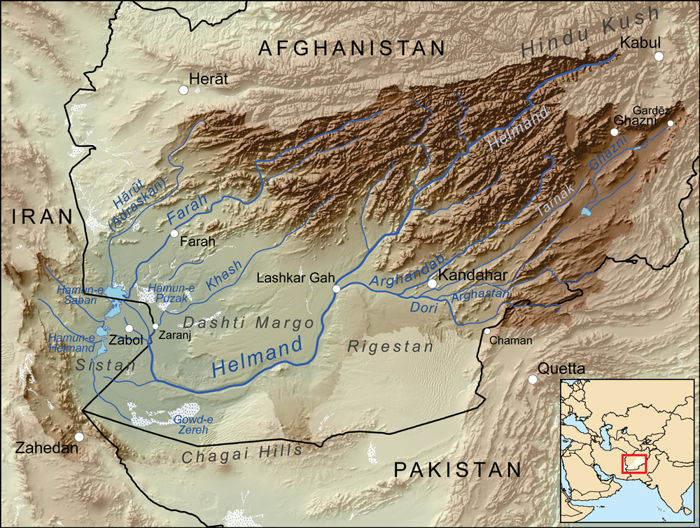
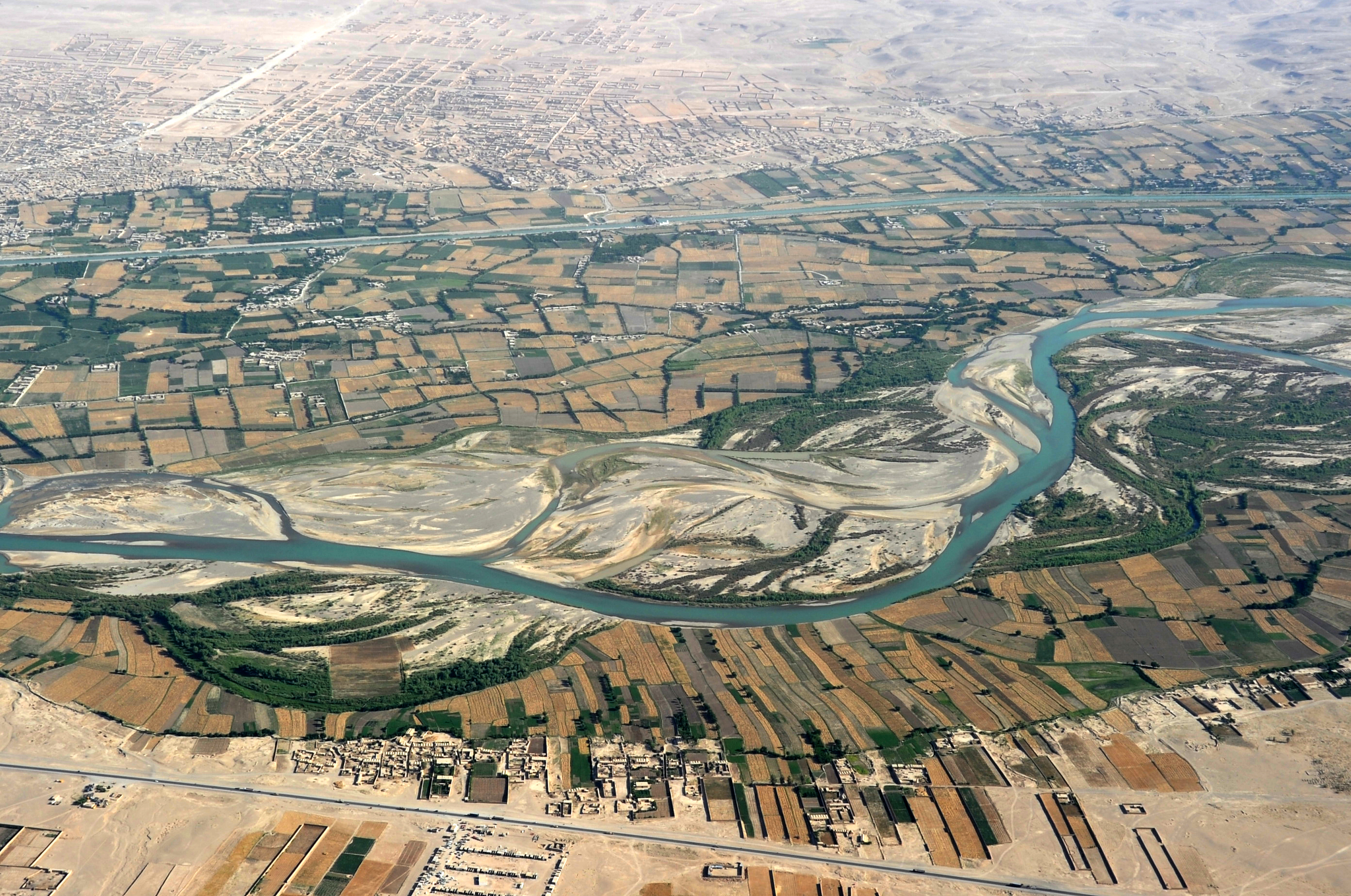
The Helmand River (also spelled Helmend, or Helmund, Hirmand; Pashto/ Persian: ; Greek: ' (''Etýmandros''); Latin: ') is the longest river in Afghanistan and the primary watershed for the endorheic Sistan Basin. It emerges in the Sanglakh Range of the Hindu Kush mountains in the northeastern part of Maidan Wardak Province, where it is separated from the watershed of the Kabul River by the Unai Pass. The Helmand feeds into the Hamun Lake on the border between Afghanistan and Iran. Etymology The name comes from the Avestan ''Haētumant'', literally "dammed, having a dam", which referred to the Helmand River and the irrigated areas around it. Geography The Helmand River stretches for . It rises in the northeastern part of Maidan Wardak Province in the Hindu Kush mountains, about 40 km west of Kabul (), flowing southwestward through Daykundi Province and Uruzgan Province. After passing through the city of Lashkargah in Helmand Province, it enters the desert o ... [...More Info...] [...Related Items...] OR: [Wikipedia] [Google] [Baidu] |
Boghra Irrigation Canal
Boghra Irrigation Canal or Nahr-e Bughra is a canal some 155 kilometres long in central Afghanistan in Helmand Province, serving to divert water from the Helmand River and the Arghandab for farmland. The Afghan government received US funding of $21 million on November 23, 1949, for the canal system. The Boghra, Shamalon and Marja canals were completed by 1954. It is controlled by the Helmand and Arghandab Valley Authority The Helmand and Arghandab Valley Authority (HAVA) based in Lashkar Gah, Afghanistan, originally named the Helmand Valley Authority (HVA) until its expansion in 1965,Canals in Afghanistan Helmand River [...More Info...] [...Related Items...] OR: [Wikipedia] [Google] [Baidu] |
Endorheic Basin
An endorheic basin (; also spelled endoreic basin or endorreic basin) is a drainage basin that normally retains water and allows no outflow to other external bodies of water, such as rivers or oceans, but drainage converges instead into lakes or swamps, permanent or seasonal, that equilibrate through evaporation. They are also called closed or terminal basins, internal drainage systems, or simply basins. Endorheic regions contrast with exorheic regions. Endorheic water bodies include some of the largest lakes in the world, such as the Caspian Sea, the world's largest inland body of water. Basins with subsurface outflows which eventually lead to the ocean are generally not considered endorheic; they are cryptorheic. Endorheic basins constitute local base levels, defining a limit of erosion and deposition processes of nearby areas. Etymology The term was borrowed from French ''endor(rh)éisme'', coined from the combining form ''endo-'' (from grc, ἔνδον ''éndon'' 'with ... [...More Info...] [...Related Items...] OR: [Wikipedia] [Google] [Baidu] |
Sistan
Sistān ( fa, سیستان), known in ancient times as Sakastān ( fa, سَكاستان, "the land of the Saka"), is a historical and geographical region in present-day Eastern Iran ( Sistan and Baluchestan Province) and Southern Afghanistan ( Nimruz, Helmand, Kandahar). Largely desert, the region is bisected by the Helmand River, the largest river in Afghanistan, which empties into the Hamun Lake that forms part of the border between the two countries. Etymology Sistan derives its name from ''Sakastan'' ("the land of the Saka"). The Sakas were a Scythian tribe which from the 2nd century BC to the 1st century migrated to the Iranian Plateau and Indus valley, where they carved a kingdom known as the Indo-Scythian Kingdom. In the Bundahishn, a Zoroastrian scripture written in Pahlavi, the province is called "Seyansih". After the Arab conquest of Iran, the province became known as Sijistan/Sistan. The more ancient Old Persian name of the region - prior to Saka dominanc ... [...More Info...] [...Related Items...] OR: [Wikipedia] [Google] [Baidu] |
Dashti Margo
Dasht-e Margo ( Persian: دشت مارگو), also Dasht-e Mārgow or Dasht-e Margoh, is a desert region in the southern provinces of Nimruz and Helmand in Afghanistan. The desert is adjacent to the Dasht-e Khash and Registan Desert. It is the world's 20th largest desert at about 150,000 km2 in area with an elevation of 500–700 m. The desert consists mainly of sand masses and rocky-clayish plains with solonchaks, takirs, and rarely oases. The desert's name means "Desert of Death" in Dari, with ''dasht'' meaning "plain In geography, a plain is a flat expanse of land that generally does not change much in elevation, and is primarily treeless. Plains occur as lowlands along valleys or at the base of mountains, as coastal plains, and as plateaus or uplands ..." and ''margo'' meaning "death". References External links * Deserts of Afghanistan Geography of Helmand Province Geography of Nimruz Province {{Nimruz-geo-stub ... [...More Info...] [...Related Items...] OR: [Wikipedia] [Google] [Baidu] |
Helmand Province
Helmand (Pashto/Dari: ; ), also known as Hillmand, in ancient times, as Hermand and Hethumand, is one of the 34 provinces of Afghanistan, in the south of the country. It is the largest province by area, covering area. The province contains 13 districts, encompassing over 1,000 villages, and roughly 1,446,230 settled people. Lashkargah serves as the provincial capital. Helmand was part of the '' Greater Kandahar'' region until made into a separate province by the Afghan government in the 20th century. The Helmand River flows through the mainly desert region of the province, providing water used for irrigation. The Kajaki Dam, which is one of Afghanistan's major reservoirs, is located in the Kajaki district. Helmand is believed to be one of the world's largest opium producing regions, responsible for around 42% of the world's total production. This is believed to be more than the whole of Myanmar, which is the second-largest producing nation after Afghanistan. The region al ... [...More Info...] [...Related Items...] OR: [Wikipedia] [Google] [Baidu] |
Lashkargah
Lashkargāh ( ps, لښکرګاه; fa, لشکرگاه), historically called Bost or Boost (), is a city in southwestern Afghanistan and the capital of Helmand Province. It is located in Lashkargah District, where the Arghandab River merges into the Helmand River. The city has a population of 201,546 as of 2006. Lashkargah is linked by major roads with Kandahar to the east, Zaranj on the border with Iran to the west, and Farah and Herat to the north-west. It is mostly very arid and desolate. However, farming does exist around the Helmand and Arghandab rivers. Bost Airport is located on the east bank of the Helmand River, five miles north of the junction of the Helmand and Arghandab rivers. Because of the trading hubs, it is Afghanistan's second largest city in size, after Kabul and before Kandahar. After several weeks of fighting in the Battle of Lashkargah, the city was captured by the Taliban on 13 August 2021, becoming the fourteenth provincial capital to be seized by t ... [...More Info...] [...Related Items...] OR: [Wikipedia] [Google] [Baidu] |
Uruzgan Province
Uruzgan (Dari), also spelled as Urozgan or Oruzgan, is one of the thirty-four provinces of Afghanistan. Uruzgan is located in the center of the country. The population is 436,079, and the province is mostly a tribal society. Tarinkot serves as the capital of the province. In 2004, the new Daykundi Province was carved out of an area in the north. Uruzgan borders the provinces of Kandahar, Daykundi, Ghazni, Zabul, and Helmand. Geography Uruzgan province is located in southern Afghanistan, bordering Zabul and Kandahar to the south, Helmand to the southwest, Daykundi to the north, and Ghazni to the east. Uruzgan covers an area of . Much of the province is mountainous or semi-mountainous terrain, while the rest of the area is made up of flat land. History The Arabs were first to arrive in Uruzgan in the 7th century when they brought Islam to the region followed by the Saffarids who conquered the place in the 9th centur [...More Info...] [...Related Items...] OR: [Wikipedia] [Google] [Baidu] |
Daykundi Province
Daykundi ( prs, دایکندی) also spelled as Daikundi, Daykondi, Daikondi or Dai Kundi, is one of the thirty-four provinces of Afghanistan, located in the central part of the country. It has a population of about 516,504, and is a Hazara Province. Daykundi Province was carved out of the northern part of Uruzgan Province in 2004, becoming a separate province. It falls into the traditionally ethnic Hazara region known as the Hazaristan (Hazarajat) and the provincial capital is Nili. It is surrounded by Bamyan Province in the northeast, Ghazni Province in the southeast, Uruzgan Province in the south, Helmand Province in the southwest, and Ghor Province in the northwest. History Daykundi was established on March 28, 2004, when it was created from the isolated Hazara-dominated northern districts of neighboring Uruzgan Province. Development and security The province maintains its own security through the Afghan police and military. While the Government of Afghanistan, ... [...More Info...] [...Related Items...] OR: [Wikipedia] [Google] [Baidu] |
Kabul
Kabul (; ps, , ; , ) is the capital and largest city of Afghanistan. Located in the eastern half of the country, it is also a municipality, forming part of the Kabul Province; it is administratively divided into 22 municipal districts. According to late 2022 estimates, the population of Kabul was 13.5 million people. In contemporary times, the city has served as Afghanistan's political, cultural, and economical centre, and rapid urbanisation has made Kabul the 75th-largest city in the world and the country's primate city. The modern-day city of Kabul is located high up in a narrow valley between the Hindu Kush, and is bounded by the Kabul River. At an elevation of , it is one of the highest capital cities in the world. Kabul is said to be over 3,500 years old, mentioned since at least the time of the Achaemenid Persian Empire. Located at a crossroads in Asia—roughly halfway between Istanbul, Turkey, in the west and Hanoi, Vietnam, in the east—it is situated in a stra ... [...More Info...] [...Related Items...] OR: [Wikipedia] [Google] [Baidu] |
Avestan
Avestan (), or historically Zend, is an umbrella term for two Old Iranian languages: Old Avestan (spoken in the 2nd millennium BCE) and Younger Avestan (spoken in the 1st millennium BCE). They are known only from their conjoined use as the scriptural language of Zoroastrianism, and the Avesta likewise serves as their namesake. Both are early Eastern Iranian languages within the Indo-Iranian language branch of the Indo-European language family. Its immediate ancestor was the Proto-Iranian language, a sister language to the Proto-Indo-Aryan language, with both having developed from the earlier Proto-Indo-Iranian language; as such, Old Avestan is quite close in both grammar and lexicon to Vedic Sanskrit, the oldest preserved Indo-Aryan language. The Avestan text corpus was composed in the ancient Iranian satrapies of Arachosia, Aria, Bactria, and Margiana, corresponding to the entirety of present-day Afghanistan as well as parts of Tajikistan, Turkmenistan, and Uzbekistan. T ... [...More Info...] [...Related Items...] OR: [Wikipedia] [Google] [Baidu] |
Hamun Lake
Lake Hāmūn ( fa, دریاچه هامون, ''Daryācheh-ye Hāmūn''; ps, هامون ډنډ), or the Hamoun Oasis, is a seasonal lake and wetlands in the Endorheic basin, endorheic Sistan Basin, Sīstān Basin in the Sistan region on the Afghanistan–Iran border. In Iran, it is also known as ''Hāmūn-e Helmand'', ''Hāmūn-e Hīrmand'', or ''Daryācheh-ye Sīstān'' ("Lake Sīstān"). ''Hamuns, Hāmūn'' is a generic term which refers to shallow lakes (or lagoons), usually seasonal, that occur in the deserts of southeast Iran and adjacent areas of Afghanistan and Pakistan as a product of snowmelt in nearby mountains in spring. The term Hāmūn Lake (or Lake Hāmūn) is equally applied to ''Hāmūn-e Helmand'' (entirely in Iran), as well to the shallow lakes Hāmūn-e Sabari and Hāmūn-e Puzak, which extend into the territory of present-day Afghanistan with latter being almost entirely inside Afghanistan. The Hamun is fed by numerous seasonal water tributaries; the main tribu ... [...More Info...] [...Related Items...] OR: [Wikipedia] [Google] [Baidu] |
Unai Pass
The Unai Pass or Onai Pass is a mountain pass on the western side of the Paghman Mountains in Jalrez District, Maidan Wardak Province, Afghanistan. It is of strategical importance due to its geographical location to the southwest of Kabul Kabul (; ps, , ; , ) is the capital and largest city of Afghanistan. Located in the eastern half of the country, it is also a municipality, forming part of the Kabul Province; it is administratively divided into 22 municipal districts. Acco .... The Sarchashma River flows through the pass, which is the upstream part of the Kabul River. The Maidan River, a tributary of the Kabul/Sarchashma rises at the pass at an altitude of about . Due to its importance, the pass has a long history of being involved in conflict in Afghanistan. In 1929, Muhammad Mir Fath (1901-1964) was one of three Hazara commanders who defeated the forces of Habibullah Kalakani at the pass between March and September of that year. The '' mujahedin'' took the Unai P ... [...More Info...] [...Related Items...] OR: [Wikipedia] [Google] [Baidu] |


