|
Fatih
Fatih () is a district of and a municipality (''belediye'') in Istanbul, Turkey, and home to almost all of the provincial authorities (including the governor's office, police headquarters, metropolitan municipality and tax office) but not the courthouse. It encompasses the peninsula coinciding with old Constantinople. In 2009, the district of Eminönü, which had been a separate municipality located at the tip of the peninsula, was once again remerged into Fatih because of its small population. Fatih is bordered by the Golden Horn to the north and the Sea of Marmara to the south, while the Western border is demarked by the Theodosian wall and the east by the Bosphorus Strait. History Byzantine era Historic Byzantine districts encompassed by present-day Fatih include: ''Exokiónion'', ''Aurelianae'', ''Xerólophos'', '' ta Eleuthérou'', ''Helenianae'', ''ta Dalmatoú'', ''Sígma'', '' Psamátheia'', ''ta Katakalón'', ''Paradeísion'', ''ta Olympíou'', ''ta Kýrou'', ... [...More Info...] [...Related Items...] OR: [Wikipedia] [Google] [Baidu] |
Mehmet The Conqueror
Mehmed II ( ota, محمد ثانى, translit=Meḥmed-i s̱ānī; tr, II. Mehmed, ; 30 March 14323 May 1481), commonly known as Mehmed the Conqueror ( ota, ابو الفتح, Ebū'l-fetḥ, lit=the Father of Conquest, links=no; tr, Fâtih Sultan Mehmed, links=no), was an Ottoman sultan who ruled from August 1444 to September 1446, and then later from February 1451 to May 1481. In Mehmed II's first reign, he defeated the crusade led by John Hunyadi after the Hungarian incursions into his country broke the conditions of the truce Peace of Szeged. When Mehmed II ascended the throne again in 1451, he strengthened the Ottoman navy and made preparations to attack Constantinople. At the age of 21, he conquered Constantinople (modern-day Istanbul) and brought an end to the Byzantine Empire. After the conquest Mehmed claimed the title Caesar of the Roman Empire ( ota, قیصر روم, Qayser-i Rûm, links=no), based on the fact that Constantinople had been the seat and capital of ... [...More Info...] [...Related Items...] OR: [Wikipedia] [Google] [Baidu] |
Istanbul (34223582516) (cropped)
) , postal_code_type = Postal code , postal_code = 34000 to 34990 , area_code = +90 212 (European side) +90 216 (Asian side) , registration_plate = 34 , blank_name_sec2 = GeoTLD , blank_info_sec2 = .ist, .istanbul , website = , blank_name = GDP (Nominal) , blank_info = 2021 , blank1_name = - Total , blank1_info = US$ 248 billion , blank2_name = - Per capita , blank2_info = US$ 15,666 , blank3_name = HDI (2019) , blank3_info = 0.846 () · 1st , timezone = TRT , utc_offset = +3 , module = , name = , government_type = Mayor–council government , governing_body = Municipal Council of Istanbul , image_shield = , established_date = 11 May 330 AD , imag ... [...More Info...] [...Related Items...] OR: [Wikipedia] [Google] [Baidu] |
Istanbul Asv2021-11 Img65 Walls Of Constantinople
) , postal_code_type = Postal code , postal_code = 34000 to 34990 , area_code = +90 212 (European side) +90 216 (Asian side) , registration_plate = 34 , blank_name_sec2 = GeoTLD , blank_info_sec2 = .ist, .istanbul , website = , blank_name = GDP (Nominal) , blank_info = 2021 , blank1_name = - Total , blank1_info = US$ 248 billion , blank2_name = - Per capita , blank2_info = US$ 15,666 , blank3_name = HDI (2019) , blank3_info = 0.846 () · 1st , timezone = TRT , utc_offset = +3 , module = , name = , government_type = Mayor–council government , governing_body = Municipal Council of Istanbul , image_shield = , established_date = 11 May 330 AD , image_ ... [...More Info...] [...Related Items...] OR: [Wikipedia] [Google] [Baidu] |
Istanbul Province
) , postal_code_type = Postal code , postal_code = 34000 to 34990 , area_code = +90 212 (European side) +90 216 (Asian side) , registration_plate = 34 , blank_name_sec2 = GeoTLD , blank_info_sec2 = .ist, .istanbul , website = , blank_name = GDP (Nominal) , blank_info = 2021 , blank1_name = - Total , blank1_info = US$ 248 billion , blank2_name = - Per capita , blank2_info = US$ 15,666 , blank3_name = HDI (2019) , blank3_info = 0.846 () · 1st , timezone = TRT , utc_offset = +3 , module = , name = , government_type = Mayor–council government , governing_body = Municipal Council of Istanbul , image_shield = , established_date = 11 May 330 AD , image_m ... [...More Info...] [...Related Items...] OR: [Wikipedia] [Google] [Baidu] |
Istanbul Panorama (16293921746)
) , postal_code_type = Postal code , postal_code = 34000 to 34990 , area_code = +90 212 (European side) +90 216 (Asian side) , registration_plate = 34 , blank_name_sec2 = GeoTLD , blank_info_sec2 = .ist, .istanbul , website = , blank_name = GDP (Nominal) , blank_info = 2021 , blank1_name = - Total , blank1_info = US$ 248 billion , blank2_name = - Per capita , blank2_info = US$ 15,666 , blank3_name = HDI (2019) , blank3_info = 0.846 () · 1st , timezone = TRT , utc_offset = +3 , module = , name = , government_type = Mayor–council government , governing_body = Municipal Council of Istanbul , image_shield = , established_date = 11 May 330 AD , image_m ... [...More Info...] [...Related Items...] OR: [Wikipedia] [Google] [Baidu] |
Istanbul
) , postal_code_type = Postal code , postal_code = 34000 to 34990 , area_code = +90 212 (European side) +90 216 (Asian side) , registration_plate = 34 , blank_name_sec2 = GeoTLD , blank_info_sec2 = .ist, .istanbul , website = , blank_name = GDP (Nominal) , blank_info = 2021 , blank1_name = - Total , blank1_info = US$ 248 billion , blank2_name = - Per capita , blank2_info = US$ 15,666 , blank3_name = HDI (2019) , blank3_info = 0.846 () · 1st , timezone = TRT , utc_offset = +3 , module = , name = , government_type = Mayor–council government , governing_body = Municipal Council of Istanbul , image_shield = , established_date = 11 May 330 AD , im ... [...More Info...] [...Related Items...] OR: [Wikipedia] [Google] [Baidu] |
Hagia Sophia
Hagia Sophia ( 'Holy Wisdom'; ; ; ), officially the Hagia Sophia Grand Mosque ( tr, Ayasofya-i Kebir Cami-i Şerifi), is a mosque and major cultural and historical site in Istanbul, Turkey. The cathedral was originally built as a Greek Orthodox church which lasted from 360 AD until the conquest of Constantinople by the Ottoman Empire in 1453. It served as a mosque until 1935, when it became a museum. In 2020, the site once again became a mosque. The current structure was built by the eastern Roman emperor Justinian I as the Christian cathedral of Constantinople for the state church of the Roman Empire between 532 and 537, and was designed by the Greek geometers Isidore of Miletus and Anthemius of Tralles. It was formally called the Church of the Holy Wisdom () and upon completion became the world's largest interior space and among the first to employ a fully pendentive dome. It is considered the epitome of Byzantine architecture and is said to have "changed the history of ... [...More Info...] [...Related Items...] OR: [Wikipedia] [Google] [Baidu] |
Fener
Fener (; Greek: Φανάρι, ''Phanári''; in English also: Phanar) is a quarter midway up the Golden Horn in the district of Fatih in Istanbul, Turkey. Its name is a Turkish transliteration of the word "phanarion" (Medieval Greek: Φανάριον), meaning lantern, streetlight or lamppost and it was so called because of a column topped with a lantern which stood here in the Byzantine period and was used as a street light or lighthouse. Fener was a traditionally Greek neighbourhood during the Ottoman era and its streets still contain many old stone houses and churches dating from Byzantine and Ottoman times. The grand mansions between the main road and the shore of the Golden Horn were often used to store wood imported from the Black Sea (Pontos) area; one now houses Istanbul's Women's Library. Their picturesque facades were damaged as a result of street-widening work from the 1930s onwards. Fener is sandwiched between Cibali and Balat on the southern shore of the Golden Horn ... [...More Info...] [...Related Items...] OR: [Wikipedia] [Google] [Baidu] |
Bosphorus Strait
The Bosporus Strait (; grc, Βόσπορος ; tr, İstanbul Boğazı 'Istanbul strait', colloquially ''Boğaz'') or Bosphorus Strait is a natural strait and an internationally significant waterway located in Istanbul in northwestern Turkey. It forms part of the continental boundary between Asia and Europe, and divides Turkey by separating Anatolia from Thrace. It is the world's narrowest strait used for international navigation. Most of the shores of the Bosporus Strait, except for the area to the north, are heavily settled, with the city of Istanbul's metropolitan population of 17 million inhabitants extending inland from both banks. The Bosporus Strait and the Dardanelles Strait at the opposite end of the Sea of Marmara are together known as the Turkish Straits. Sections of the shore of the Bosporus in Istanbul have been reinforced with concrete or rubble and those sections of the Strait prone to deposition are periodically dredged. Name The name of the ... [...More Info...] [...Related Items...] OR: [Wikipedia] [Google] [Baidu] |
Eminönü
Eminönü is a predominantly commercial waterfront area of Istanbul within the Fatih district near the confluence of the Golden Horn with the southern entrance of the Bosphorus strait and the Sea of Marmara. It is connected to Karaköy (historic Galata) via the Galata Bridge across the Golden Horn. It was administered as part of the Sultanahmet district from 1928 to 2009 when Sultanahmet was absorbed into Fatih. Eminönü's busy main square is overlooked by the New Mosque (Yeni Cami in Turkish) and the Spice Bazaar (Mısır Çarşısı in Turkish). Eminönü is an important transport hub. Several ferries have terminals along the Eminönü waterfront and the T1 tram has a stop here. To the southeast Eminönü runs into Sirkeci, while to the northwest it merges with the shopping areas of Tahtakale and Küçükpazar. Inland from Emiõnü is another shopping district, Mahmutpaşa. In Turkish, Eminönü means 'in front of justice' ('emin' meaning 'justice' and 'önü' meaning ... [...More Info...] [...Related Items...] OR: [Wikipedia] [Google] [Baidu] |
Constantinople
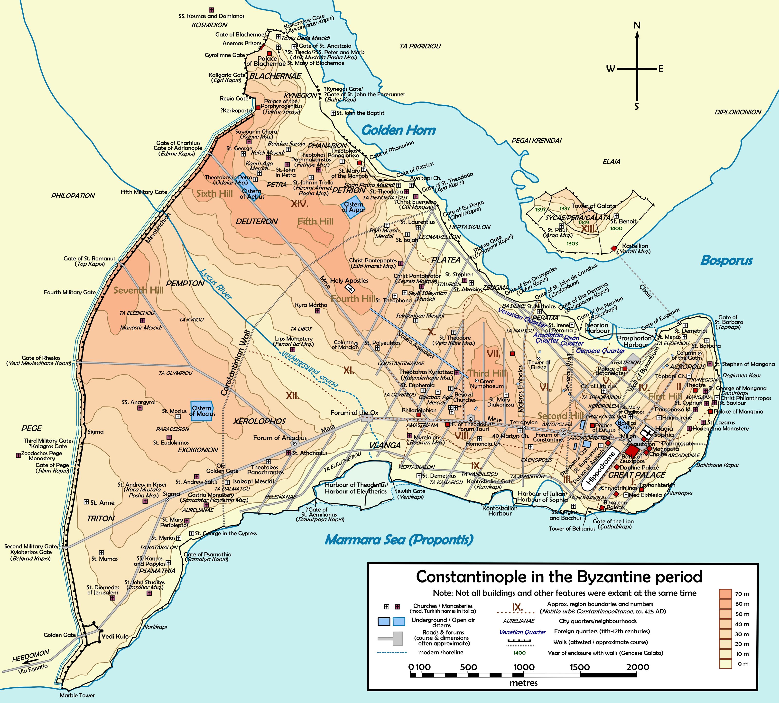
la, Constantinopolis ota, قسطنطينيه , alternate_name = Byzantion (earlier Greek name), Nova Roma ("New Rome"), Miklagard/Miklagarth (Old Norse), Tsargrad ( Slavic), Qustantiniya ( Arabic), Basileuousa ("Queen of Cities"), Megalopolis ("the Great City"), Πόλις ("the City"), Kostantiniyye or Konstantinopolis ( Turkish) , image = Byzantine Constantinople-en.png , alt = , caption = Map of Constantinople in the Byzantine period, corresponding to the modern-day Fatih district of Istanbul , map_type = Istanbul#Turkey Marmara#Turkey , map_alt = A map of Byzantine Istanbul. , map_size = 275 , map_caption = Constantinople was founded on the former site of the Greek colony of Byzantion, which today is known as Istanbul in Turkey. , coordinates = , location = Fatih, İstanbul, Turkey , region = Marmara Region , type = Imperial city , part_of = , length = , width ... [...More Info...] [...Related Items...] OR: [Wikipedia] [Google] [Baidu] |
Samatya
Samatya ( el, Ψαμάθεια, pr. ''Psamatheia''; hy, Սամաթիա) is a quarter of the Fatih district of Istanbul. It is located along the Marmara Sea, and borders to the west on the neighborhood of Yedikule (the "Castle of the Seven Towers"). Etymology The name originates from the Greek word ''psamathion'' (), meaning "sandy", because of the great quantity of sand found in the quarter. History About 383 AD, the first monastic institution was established in Constantinople, at Psamatheia, at that time still outside the walled city.Tsai, Kathryn (Dr). ''A Timeline of Eastern Church History''. Divine Ascent Press, CA, 2004. p.73. Up to recent times, Samatya was mostly inhabited by Armenians, who were settled here in 1458 by Sultan Mehmet II,Müller-Wiener (1977), p. 200 and who own there the church of '' Surp Kevork'', also called ''Sulu Manastiri'' (Water's monastery) – previously an Eastern Orthodox church which dates back to before the Ottoman conquest, and by Greeks ... [...More Info...] [...Related Items...] OR: [Wikipedia] [Google] [Baidu] |
.jpg)


.jpg)

