|
Denaby
Denaby is a civil parish in the Metropolitan Borough of Doncaster in South Yorkshire, England. It has a population of 326, increasing slightly to 329 at the 2011 Census. The only village in the parish, historically known as Denaby, is now known as Old Denaby to distinguish it from Denaby Main, which lies outside the parish to the east in the unparished area of Mexborough and Conisbrough Conisbrough () is a town within the City of Doncaster, in South Yorkshire, England. It is roughly midway between Doncaster and Rotherham, and is built alongside the River Don at . It has a ward population (Conisbrough and Denaby) of 14,333. .... Old Denaby is in the Parliamentary constituency of Don Valley. References Civil parishes in South Yorkshire Geography of the Metropolitan Borough of Doncaster {{SouthYorkshire-geo-stub ... [...More Info...] [...Related Items...] OR: [Wikipedia] [Google] [Baidu] |
Denaby Main
Denaby Main is a village situated between Mexborough and Conisbrough in the Metropolitan Borough of Doncaster in South Yorkshire, England. The village falls within the Doncaster MBC ward of Conisbrough and Denaby. It was built by the Denaby Main Colliery Company to house its workers and their families, and originally given the name Denaby Main Colliery Village, to distinguish it from the village of Denaby, about ⅔ mile away on the road to Hooton Roberts and Kilnhurst; from that time, the old village became known as Old Denaby. In due course the "Colliery Village" part of the name was lost, leaving the village to be known as Denaby Main. History Around 1700 poor-quality coal was found, close by the surface, just over the River Don from Mexborough and this, in time, led to the sinking of two shafts, in 1863, for Denaby Main Colliery Company, owned by Messrs Pope and Pearson. The Barnsley bed was reached in September 1867 at a depth of more than 1,266 feet. In 1893 the compa ... [...More Info...] [...Related Items...] OR: [Wikipedia] [Google] [Baidu] |
Conisbrough
Conisbrough () is a town within the City of Doncaster, in South Yorkshire, England. It is roughly midway between Doncaster and Rotherham, and is built alongside the River Don at . It has a ward population (Conisbrough and Denaby) of 14,333. Etymology The name ''Conisbrough'' comes from the Old English (first recorded ) meaning "king's stronghold" or "king's fortified place". Its derivation has a very similar route to Kingsbury. History The historian David Hey describes Conisbrough as appearing to be the most important place in Anglo-Saxon and Viking South Yorkshire. In a will of around 1003, Conisbrough was bequeathed by Wulfric Spott, founder of Burton Abbey. At this point, it appears to have been the centre of a major former royal estate, reaching Hatfield Chase. The manor became royal again under Harold II of England, and by the Norman Conquest, 28 townships in what is now South Yorkshire belonged to the Lord of Conisbrough. William the Conqueror gave the whole lo ... [...More Info...] [...Related Items...] OR: [Wikipedia] [Google] [Baidu] |
Civil Parishes In South Yorkshire
A civil parish is a country subdivision, forming the lowest unit of local government in England. There are 94 civil parishes in the ceremonial county of South Yorkshire, most of the county being unparished. At the 2001 census, there were 360,191 people living in the parishes, increasing to 369,220 in 2011, accounting for 27.5 per cent of the county's population. History Parishes arose from Church of England divisions, and were originally purely ecclesiastical divisions. Over time they acquired civil administration powers.Angus Winchester, 2000, ''Discovering Parish Boundaries''. Shire Publications. Princes Risborough, 96 pages The Highways Act 1555 made parishes responsible for the upkeep of roads. Every adult inhabitant of the parish was obliged to work four days a year on the roads, providing their own tools, carts and horses; the work was overseen by an unpaid local appointee, the ''Surveyor of Highways''. The poor were looked after by the monasteries, until their dissol ... [...More Info...] [...Related Items...] OR: [Wikipedia] [Google] [Baidu] |
Mexborough
Mexborough is a town in the City of Doncaster in South Yorkshire, England. Situated between Manvers and Denaby Main, it lies on the River Don close to where it joins the River Dearne, and the A6023 road runs through the town. It is contiguous with the town of Swinton which is directly to the southwest immediately across the railway and Conisbrough to the east. Historically part of the West Riding of Yorkshire, Mexborough has a population of 14,750, increasing to a ward population of 15,244 at the 2011 Census. History The name ''Mexborough'' combines the Old English suffix ''burh'', meaning a fortified place, with an Old English or Old Norse personal name, which may be ''Meke'', ''Muik'', ''Meoc'' or ''Mjukr''. Mexborough is located at the north-eastern end of a dyke known as the ''Roman Ridge'', which is thought to have been constructed either by the Brigantian tribes in the 1st century AD, perhaps as a defence against the Roman invasion of Britain, or after the 5th c ... [...More Info...] [...Related Items...] OR: [Wikipedia] [Google] [Baidu] |
Metropolitan Borough Of Doncaster
The City of Doncaster is a metropolitan borough with city status in South Yorkshire, England. It is named after its principal settlement, Doncaster, and includes the surrounding suburbs of Doncaster as well as numerous towns and villages. The district has large amounts of countryside. At 219 sq miles, it is the largest metropolitan borough by area in England. The largest settlement in the borough are Doncaster itself, followed by the towns of Thorne, Hatfield and Mexborough (the latter of which is part of the Barnsley/Dearne Valley built-up area), and it additionally covers the towns of Conisbrough, Stainforth, Bawtry, Askern, Edlington and Tickhill. Doncaster borders the Selby district of North Yorkshire to the north, the East Riding of Yorkshire to the north-east, North Lincolnshire to the east, Bassetlaw in Nottinghamshire to the south-east, Rotherham to the south-west, Barnsley to the west, and Wakefield, West Yorkshire, to the north-west. It is part of the Yorks ... [...More Info...] [...Related Items...] OR: [Wikipedia] [Google] [Baidu] |
South Yorkshire
South Yorkshire is a ceremonial county, ceremonial and metropolitan county, metropolitan county in the Yorkshire and Humber Region of England. The county has four council areas which are the cities of City of Doncaster, Doncaster and City of Sheffield, Sheffield as well as the metropolitan boroughs, boroughs of Metropolitan Borough of Barnsley, Barnsley and Metropolitan Borough of Rotherham, Rotherham. In Northern England, it is on the east side of the Pennines. Part of the Peak District national park is in the county. The River Don, Yorkshire, River Don flows through most of the county, which is landlocked. The county had a population of 1.34 million in 2011. Sheffield largest urban centre in the county, it is the south west of the county. The Sheffield Urban Area, built-up area around Sheffield and Rotherham, with over half the county's population living within it, is the List of urban areas in the United Kingdom, tenth most populous in the United Kingdom. The majority of t ... [...More Info...] [...Related Items...] OR: [Wikipedia] [Google] [Baidu] |
Don Valley (UK Parliament Constituency)
Don Valley is a constituency in South Yorkshire represented in the House of Commons of the UK Parliament since 2019 by Nick Fletcher of the Conservative Party. Constituency profile Created in 1918, Don Valley is a former coal mining area which elected only Labour MPs from 1922 to 2019. The current MP is Nick Fletcher, elected in 2019. Boundaries 1918—1950: The Urban Districts of Mexborough and Tickhill, and the Rural Districts of Doncaster and Thorne. 1950—1983: The Urban Districts of Adwick-le-Street, Bentley with Arksey, and Tickhill, and the Rural District of Doncaster. 1983—1997: The Metropolitan Borough of Doncaster wards of Conisbrough, Edlington and Warmsworth, Mexborough, Richmond, Rossington, South East, and Southern Parks. 1997—2010: The Metropolitan Borough of Doncaster wards of Conisbrough, Edlington and Warmsworth, Hatfield, Rossington, South East, and Southern Parks. 2010–present: The Metropolitan Borough of Doncaster wards of Conisbrough and ... [...More Info...] [...Related Items...] OR: [Wikipedia] [Google] [Baidu] |
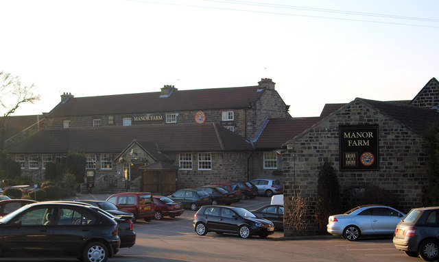
Manor Farm Public House - Geograph
Manor may refer to: Land ownership *Manorialism or "manor system", the method of land ownership (or "tenure") in parts of medieval Europe, notably England *Lord of the manor, the owner of an agreed area of land (or "manor") under manorialism *Manor house, the main residence of the lord of the manor * Estate (land), the land (and buildings) that belong to large house, synonymous with the modern understanding of a manor. *Manor (in Colonial America), a form of tenure restricted to certain Proprietary colonies *Manor (in 17th-century Canada), the land tenure unit under the Seigneurial system of New France Places * Manor railway station, a former railway station in Victoria, Australia * Manor, Saskatchewan, Canada * Manor, India, a census town in Palghar District, Maharashtra * The Manor, a luxury neighborhood in Western Hanoi, Vietnam United Kingdom * Manor (Sefton ward), a municipal borough of Sefton ward, Merseyside, England * Manor, Scottish Borders, a parish in Peebless ... [...More Info...] [...Related Items...] OR: [Wikipedia] [Google] [Baidu] |
Civil Parish
In England, a civil parish is a type of administrative parish used for local government. It is a territorial designation which is the lowest tier of local government below districts and counties, or their combined form, the unitary authority. Civil parishes can trace their origin to the ancient system of ecclesiastical parishes, which historically played a role in both secular and religious administration. Civil and religious parishes were formally differentiated in the 19th century and are now entirely separate. Civil parishes in their modern form came into being through the Local Government Act 1894, which established elected parish councils to take on the secular functions of the parish vestry. A civil parish can range in size from a sparsely populated rural area with fewer than a hundred inhabitants, to a large town with a population in the tens of thousands. This scope is similar to that of municipalities in Continental Europe, such as the communes of France. Howev ... [...More Info...] [...Related Items...] OR: [Wikipedia] [Google] [Baidu] |


