|
Deira
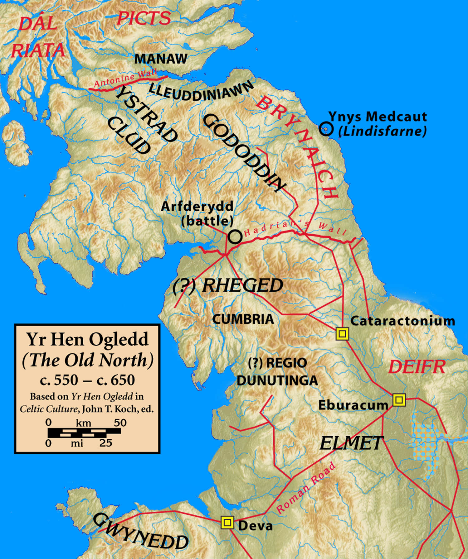
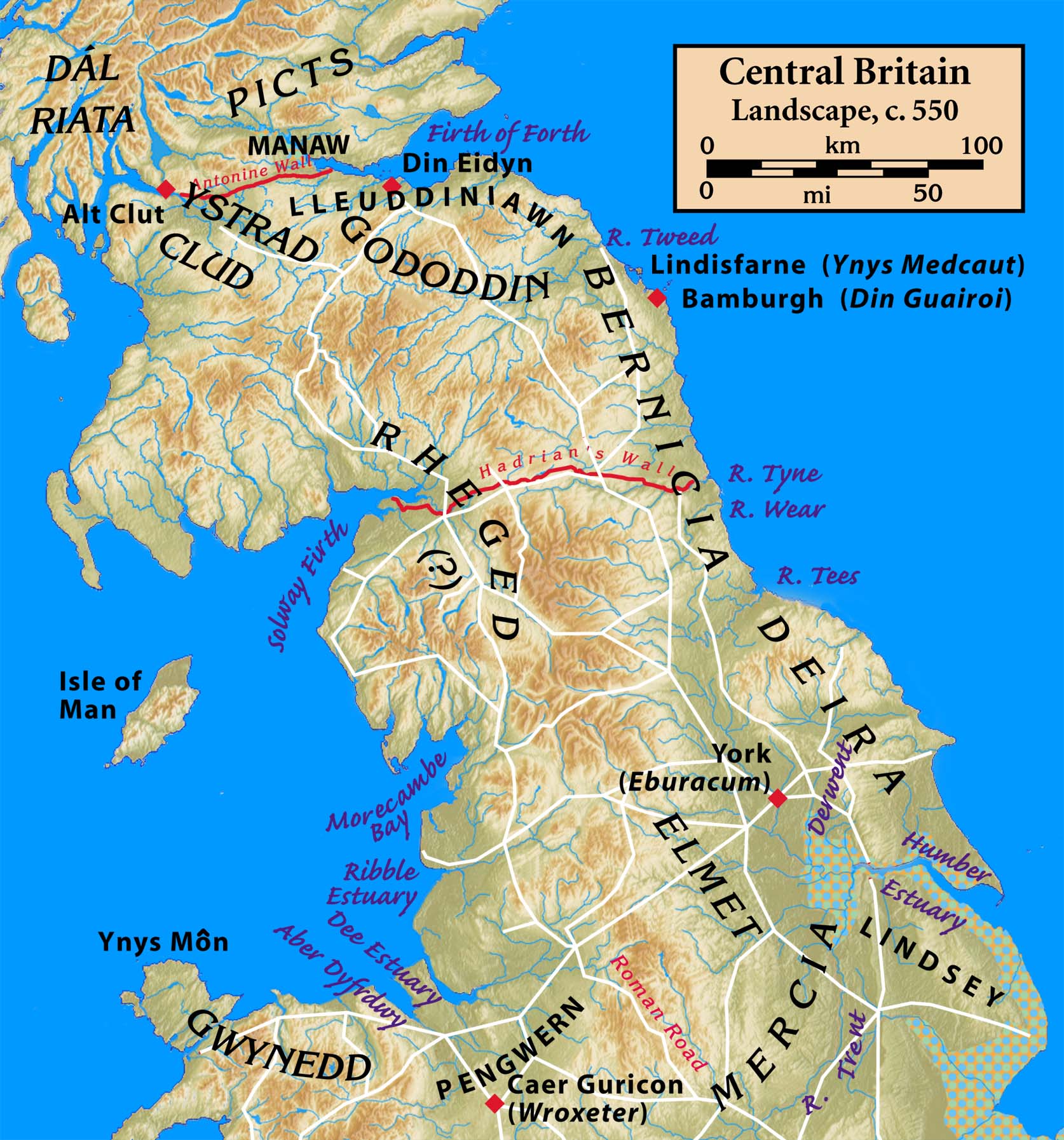
Deira ( ; Old Welsh/Cumbric: ''Deywr'' or ''Deifr''; ang, Derenrice or ) was an area of Post-Roman Britain, and a later Anglian kingdom. Etymology The name of the kingdom is of Brythonic origin, and is derived from the Proto-Celtic *''daru'', meaning 'oak' ( in modern Welsh), in which case it would mean 'the people of the Derwent', a derivation also found in the Latin name for Malton, . It is cognate with the modern Irish word (); the names for County Londonderry and the city of Derry stem from this word. History Brythonic Deira Following the Roman withdrawal from Britain a number of successor kingdoms rose in northern England, reflecting pre-Roman tribal territories. The area between the Humber and River Tees known as ''Deywr'' or ''Deifr'' corresponds to the tribal lands of the Parisi, bordered to the west and north by the Brythonic kingdoms of '' Elfed'' and ''Bryneich'' respectively, and to the east by the North Sea. Early Deira may have centred on Petuaria (mode ... [...More Info...] [...Related Items...] OR: [Wikipedia] [Google] [Baidu] |
Northumbria
la, Regnum Northanhymbrorum , conventional_long_name = Kingdom of Northumbria , common_name = Northumbria , status = State , status_text = Unified Anglian kingdom (before 876)North: Anglian kingdom (after 876)South: Danish kingdom (876–914)South: Norwegian kingdom (after 914) , life_span = 654–954 , flag_type = Oswald's Stripes, the provincial flag of Northumbria and red was previously purple , image_coat = , image_map = Map_of_the_Kingdom_of_Northumbria_around_700_AD.svg , image_map_size = 250 , image_map_caption = Northumbria around 700 AD , image_map2 = , image_map2_size = , image_map2_caption = , government_type = Monarchy , year_start = 653 , year_end = 954 , event_end = South is annexed by Kingdom of England , event1 = South is annexed by the Danelaw , date_ev ... [...More Info...] [...Related Items...] OR: [Wikipedia] [Google] [Baidu] |
Bernicia
Bernicia ( ang, Bernice, Bryneich, Beornice; la, Bernicia) was an Anglo-Saxon kingdom established by Anglian settlers of the 6th century in what is now southeastern Scotland and North East England. The Anglian territory of Bernicia was approximately equivalent to the modern English counties of Northumberland, Tyne and Wear, and Durham, as well as the Scottish counties of Berwickshire and East Lothian, stretching from the Forth to the Tees. In the early 7th century, it merged with its southern neighbour, Deira, to form the kingdom of Northumbria, and its borders subsequently expanded considerably. Brittonic ''Bryneich'' Etymologies Bernicia occurs in Old Welsh poetry as ''Bryneich'' or ''Brynaich'' and in the 9th-century '' Historia Brittonum'', (§ 61) as ''Berneich'' or ''Birneich''. This was most likely the name of the native Brittonic kingdom , whose name was then adopted by the Anglian settlers who rendered it in Old English as ''Bernice'' or ''Beornice'' . ... [...More Info...] [...Related Items...] OR: [Wikipedia] [Google] [Baidu] |
Post-Roman Britain
Sub-Roman Britain is the period of late antiquity in Great Britain between the end of Roman rule and the Anglo-Saxon settlement. The term was originally used to describe archaeological remains found in 5th- and 6th-century AD sites that hinted at the decay of locally made wares from a previous higher standard under the Roman Empire. It is now used to describe the period that commenced with the evacuation of Roman troops to Gaul by Constantine III in 407 and to have concluded with the Battle of Deorham in 577. Meaning of terms The period of sub-Roman Britain traditionally covers the history of the area which subsequently became England from the end of Roman imperial rule, traditionally dated to be in 410, to the arrival of Saint Augustine in 597. The date taken for the end of this period is arbitrary in that the sub-Roman culture continued in northern England until the merger of Rheged (the kingdom of the Brigantes) with Northumbria by dynastic marriage in 633, and longer i ... [...More Info...] [...Related Items...] OR: [Wikipedia] [Google] [Baidu] |
Hen Ogledd
Yr Hen Ogledd (), in English the Old North, is the historical region which is now Northern England and the southern Scottish Lowlands that was inhabited by the Brittonic people of sub-Roman Britain in the Early Middle Ages. Its population spoke a variety of the Brittonic language known as Cumbric which is closely related to, if not a dialect of Old Welsh. The people of Wales and the Hen Ogledd considered themselves to be one people, and both were referred to as Cymry ('fellow-countrymen') from the Brittonic word ''combrogi.'' The Hen Ogledd was distinct from the parts of North Britain inhabited by the Picts, Anglo-Saxons, and Scoti. The major kingdoms of the Hen Ogledd were Elmet, Gododdin, Rheged, and the Kingdom of Strathclyde. Smaller kingdoms included Aeron and Calchfynydd. Eidyn, Lleuddiniawn, and Manaw Gododdin were evidently parts of Gododdin. The Angle kingdoms of Deira and Bernicia both had Brittonic-derived names, suggesting they may have been Brittonic k ... [...More Info...] [...Related Items...] OR: [Wikipedia] [Google] [Baidu] |
Angles
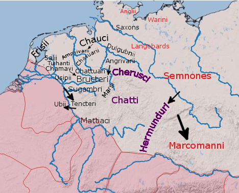
The Angles ( ang, Ængle, ; la, Angli) were one of the main Germanic peoples who settled in Great Britain in the post-Roman period. They founded several kingdoms of the Heptarchy in Anglo-Saxon England. Their name is the root of the name ''England'' ("land of Ængle"). According to Tacitus, writing around 100 AD, a people known as Angles (Anglii) lived east of the Langobards and Semnones, who lived near the Elbe river. Etymology The name of the Angles may have been first recorded in Latinised form, as ''Anglii'', in the '' Germania'' of Tacitus. It is thought to derive from the name of the area they originally inhabited, the Anglia Peninsula (''Angeln'' in modern German, ''Angel'' in Danish). Multiple theories concerning the etymology of the name have been hypothesised: # According to Gesta Danorum Dan and Angul (Angel) were made rulers by the consent of their people because of their bravery. Dan gave name to Danes and Angel gave names to Angles. # It originated ... [...More Info...] [...Related Items...] OR: [Wikipedia] [Google] [Baidu] |
Elmet
Elmet ( cy, Elfed), sometimes Elmed or Elmete, was an independent Brittonic kingdom between about the 5th century and early 7th century, in what later became the smaller area of the West Riding of Yorkshire then West Yorkshire, South Yorkshire and North Derbyshire. Geography The precise borders of the original kingdom of Elmet are unclear. Some have argued that, until the 7th century, it was bounded by the rivers Sheaf in the south and Wharfe in the east. It adjoined the kingdom of Deira to the north and Mercia to the south, and its western boundary appears to have been near Craven, which was possibly also a minor British kingdom. As such, it was not conterminous with other territories of the Britons at the time, being well to the south of others in the '' Hen Ogledd'' ("Old North"), such as Strathclyde, and north-east of Wales, Cornwall and Dumnonia. As one of the south-easternmost Brittonic regions for which there is reasonably substantial evidence, Elmet is notab ... [...More Info...] [...Related Items...] OR: [Wikipedia] [Google] [Baidu] |
York
York is a cathedral city with Roman origins, sited at the confluence of the rivers Ouse and Foss in North Yorkshire, England. It is the historic county town of Yorkshire. The city has many historic buildings and other structures, such as a minster, castle, and city walls. It is the largest settlement and the administrative centre of the wider City of York district. The city was founded under the name of Eboracum in 71 AD. It then became the capital of the Roman province of Britannia Inferior, and later of the kingdoms of Deira, Northumbria, and Scandinavian York. In the Middle Ages, it became the northern England ecclesiastical province's centre, and grew as a wool-trading centre. In the 19th century, it became a major railway network hub and confectionery manufacturing centre. During the Second World War, part of the Baedeker Blitz bombed the city; it was less affected by the war than other northern cities, with several historic buildings being gutted and ... [...More Info...] [...Related Items...] OR: [Wikipedia] [Google] [Baidu] |
River Derwent, Yorkshire
The Derwent is a river in Yorkshire in the north of England. It flows from Fylingdales Moor in the North York Moors National Park, east then southwards as far as its confluence with the River Hertford then westwards through the Vale of Pickering, south through Kirkham Gorge and the Vale of York, joining the River Ouse at Barmby on the Marsh. The confluence is unusual in that the Derwent converges on the Ouse at a shallow angle in an upstream direction. The river used to flow further east, its old course entering the Ouse east of Howden. The River Derwent catchment area includes the Upper Derwent, River Rye, River Hertford, Bielby Beck and Pocklington Canal and their tributaries. It covers an area of 2,057 square kilometres and includes the towns of Stamford Bridge, Malton, Pickering, Helmsley, Filey and Scarborough. The area is bounded by the Cleveland Hills, North York Moors and Hambleton Hills to the north, the Yorkshire Wolds and the coast to the east, the Vale ... [...More Info...] [...Related Items...] OR: [Wikipedia] [Google] [Baidu] |
River Tees
The River Tees (), in Northern England, rises on the eastern slope of Cross Fell in the North Pennines and flows eastwards for to reach the North Sea between Hartlepool and Redcar near Middlesbrough. The modern day history of the river has been tied with the industries on Teesside in its lower reaches, where it has provided the means of import and export of goods to and from the North East England. The need for water further downstream also meant that reservoirs were built in the extreme upper reaches, such as Cow Green Reservoir, Cow Green. Etymology The name ''Tees'' is possibly of Common Brittonic, Brittonic origin. The element ''*tēs'', meaning "warmth" with connotations of "boiling, excitement" (Welsh language, Welsh ''tes''), may underlie the name. ''*Teihx-s'', a root possibly derived from Brittonic ''*ti'' (Welsh ''tail'', "dung, manure"), has also been used to explain the name ''Tees'' (compare River Tyne#Origins of name, River Tyne). Geography The river drains and ... [...More Info...] [...Related Items...] OR: [Wikipedia] [Google] [Baidu] |
Parisi (tribe)
The Parisi were a British Celtic tribe located somewhere within the present-day East Riding of Yorkshire, in England, known from a single brief reference by Ptolemy in his ''Geographica'' of about AD 150. Many writers have connected them with the archaeological Arras culture and some with the more widely known Parisii of Gaul. Historical sources and archaeology The Parisi are known from a description in Ptolemy's ''Geographica'' (''Geographica'' II, 3, 10) which locates them to near ''Opportunum Sinus'' ("Good harbour"). Ptolemy is presumed never to have visited Roman Britain, compiling his work from existing sources, probably in Alexandria. The tribe is inferred to have been surrounded by the Brigantes, and with the Coritani south of them across the Humber. Ptolemy mentions the Parisi in association with '' Petvaria'', a town thought to be located close to Brough, East Riding of Yorkshire. Ptolemy also mentions a promontory ''Promontarium Ocellum'', which may be either S ... [...More Info...] [...Related Items...] OR: [Wikipedia] [Google] [Baidu] |
Early Medieval
The Early Middle Ages (or early medieval period), sometimes controversially referred to as the Dark Ages, is typically regarded by historians as lasting from the late 5th or early 6th century to the 10th century. They marked the start of the Middle Ages of European history, following the decline of the Western Roman Empire, and preceding the High Middle Ages ( 11th to 13th centuries). The alternative term ''late antiquity'', for the early part of the period, emphasizes elements of continuity with the Roman Empire, while ''Early Middle Ages'' is used to emphasize developments characteristic of the earlier medieval period. The period saw a continuation of trends evident since late classical antiquity, including population decline, especially in urban centres, a decline of trade, a small rise in average temperatures in the North Atlantic region and increased migration. In the 19th century the Early Middle Ages were often labelled the ''Dark Ages'', a characterization based on ... [...More Info...] [...Related Items...] OR: [Wikipedia] [Google] [Baidu] |
North Sea
The North Sea lies between Great Britain, Norway, Denmark, Germany, the Netherlands and Belgium. An epeiric sea on the European continental shelf, it connects to the Atlantic Ocean through the English Channel in the south and the Norwegian Sea in the north. It is more than long and wide, covering . It hosts key north European shipping lanes and is a major fishery. The coast is a popular destination for recreation and tourism in bordering countries, and a rich source of energy resources, including wind and wave power. The North Sea has featured prominently in geopolitical and military affairs, particularly in Northern Europe, from the Middle Ages to the modern era. It was also important globally through the power northern Europeans projected worldwide during much of the Middle Ages and into the modern era. The North Sea was the centre of the Vikings' rise. The Hanseatic League, the Dutch Republic, and the British each sought to gain command of the North Sea and acc ... [...More Info...] [...Related Items...] OR: [Wikipedia] [Google] [Baidu] |


