|
Chifeng
Chifeng ( zh, s=赤峰市), also known as Ulanhad ( mn, (Улаанхад хот), ''Ulaɣanqada qota'', , "red cliff"), is a prefecture-level city in Southeastern Inner Mongolia, People's Republic of China. It borders Xilin Gol League to the north and west, Tongliao to the northeast, Chaoyang ( Liaoning) to the southeast and Chengde (Hebei) to the south. The city has a total administrative area of and as of the 2020 census, had a population of 4,035,967 inhabitants (4,341,245 in 2010). However, 1,175,391 of those residents lived in the built-up (or metro) area made of the 2 urban districts of Hongshan and Songshan, as Yuanbaoshan is not conurbated yet. However, a large part of Songshan is still rural and Yuanbaoshan is a de facto separate town 27 kilometers away from the core district of Chifeng. The city was the administrative center of the defunct Ju Ud League ( zh, s=昭乌达盟, labels=no; ). History According to archeological studies, human occupation of the Chife ... [...More Info...] [...Related Items...] OR: [Wikipedia] [Google] [Baidu] |
Inner Mongolia
Inner Mongolia, officially the Inner Mongolia Autonomous Region, is an autonomous region of the People's Republic of China. Its border includes most of the length of China's border with the country of Mongolia. Inner Mongolia also accounts for a small section of China's border with Russia ( Zabaykalsky Krai). Its capital is Hohhot; other major cities include Baotou, Chifeng, Tongliao, and Ordos. The autonomous region was established in 1947, incorporating the areas of the former Republic of China provinces of Suiyuan, Chahar, Rehe, Liaobei, and Xing'an, along with the northern parts of Gansu and Ningxia. Its area makes it the third largest Chinese administrative subdivision, constituting approximately and 12% of China's total land area. Due to its long span from east to west, Inner Mongolia is geographically divided into eastern and western divisions. The eastern division is often included in Northeastern China (Dongbei) with major cities including Tongliao, Chifeng ... [...More Info...] [...Related Items...] OR: [Wikipedia] [Google] [Baidu] |
Songshan District, Chifeng
Songshan District (Mongolian language, Mongolian: Сүн шан тоори ''Süŋ šan toɣoriɣ''; ) is a District (China), district of the city of Chifeng, Inner Mongolia, China. The district spans 5,629 square kilometers, and has a population of 608,883 as of 2019. Administrative divisions The district is divided into seven Subdistricts of China, subdistricts, nine Towns of China, towns, and five Townships of China, townships. These township-level divisions are then further divided into 244 Villages of China, administrative villages, 44 urban Residential communities of China, residential communities, and 3 rural residential communities. Geography Songshan District is bordered by Ar Horqin Banner, Ar'horqin Banner to its east, Weichang Manchu and Mongol Autonomous County to its west, Yuanbaoshan District and Hongshan District, Chifeng, Hongshan District to its south, Ongniud Banner to its north, Hexigten Banner to its northwest, and Harqin Banner to its southwest. Clim ... [...More Info...] [...Related Items...] OR: [Wikipedia] [Google] [Baidu] |
Hongshan Culture
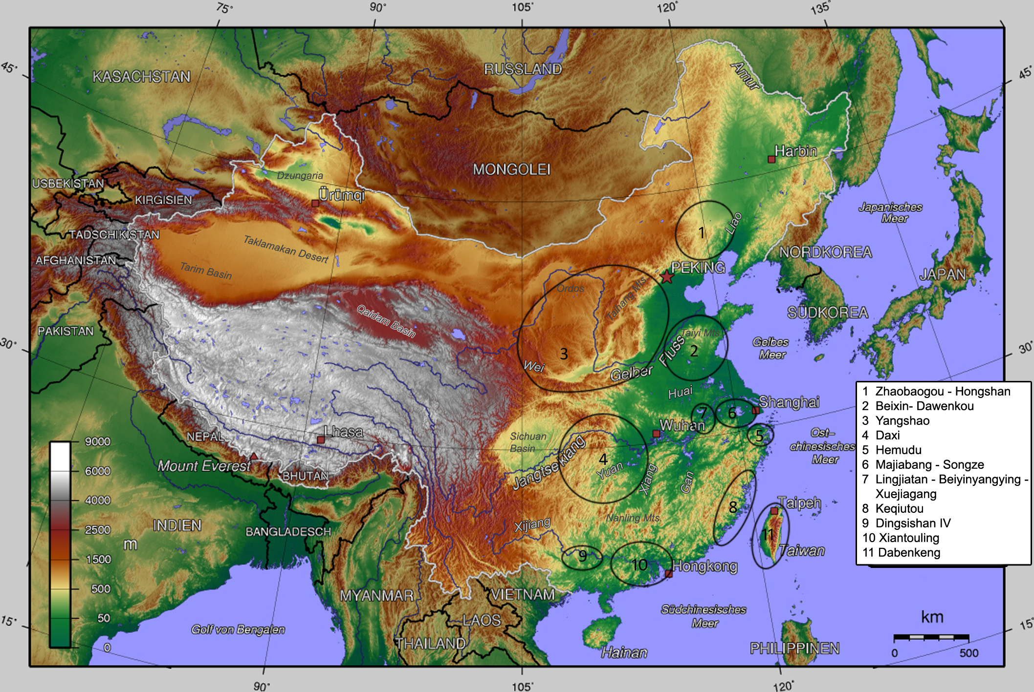
The Hongshan culture () was a Neolithic culture in the West Liao river basin in northeast China. Hongshan sites have been found in an area stretching from Inner Mongolia to Liaoning, and dated from about 4700 to 2900 BC. The culture is named after (), a site in Hongshan District, Chifeng. The site was discovered by the Japanese archaeologist Torii Ryūzō in 1908 and extensively excavated in 1935 by Kōsaku Hamada and Mizuno Seiichi. Historical context In northeast China, Hongshan culture was preceded by Xinglongwa culture (6200–5400 BC), Xinle culture (5300–4800 BC), and Zhaobaogou culture, which may be contemporary with Xinle and a little later. The Yangshao culture of the Yellow River existed contemporaneously with the Hongshan culture (see map). These two cultures interacted with each other. Hongshan culture was succeeded by the Lower Xiajiadian culture (2200–1600 BC), which was replaced by a different Upper Xiajiadian culture (1000-600 BC) with a shift from fa ... [...More Info...] [...Related Items...] OR: [Wikipedia] [Google] [Baidu] |
Hongshan District, Chifeng
Hongshan District ( Mongolian: , Күн шан тоори, ''Küŋ šan toɣoriɣ''; zh, s=红山区, t=紅山區, p=Hóngshān Qū, l=red mountain) is a district of the city of Chifeng, Inner Mongolia Inner Mongolia, officially the Inner Mongolia Autonomous Region, is an autonomous region of the People's Republic of China. Its border includes most of the length of China's border with the country of Mongolia. Inner Mongolia also accounts for a ..., People's Republic of China. References External linkswww.xzqh.org County-level divisions of Inner Mongolia Chifeng {{InnerMongolia-geo-stub ... [...More Info...] [...Related Items...] OR: [Wikipedia] [Google] [Baidu] |
Yuanbaoshan
Yuanbaoshan District ( Mongolian: ''Yuvan boo šan toɣoriɣ'', Юаньбаошань тойрог, ''Yuanĭbaoşanĭ''; ) is a district of the city of Chifeng, Inner Mongolia Inner Mongolia, officially the Inner Mongolia Autonomous Region, is an autonomous region of the People's Republic of China. Its border includes most of the length of China's border with the country of Mongolia. Inner Mongolia also accounts for a ..., People's Republic of China. References www.xzqh.org County-level divisions of Inner Mongolia Chifeng {{InnerMongolia-geo-stub ... [...More Info...] [...Related Items...] OR: [Wikipedia] [Google] [Baidu] |
Xilin Gol League
Xilingol, Xilin Gol, Shiliin Gol or Xilinguole Aimag/League (; mn, , , , ) is one of 3 leagues of Inner Mongolia. The seat is Xilinhot, and the area is . The league's economy is based on mining and agriculture. Xilingol borders Mongolia to the north, Chifeng, Tongliao and Hinggan League to the east, Ulanqab to the west and Hebei to the south. This is the only prefecture-level division of Inner Mongolia in whose southern border nomadic culture is still vivid. Some divisions, such as Tongliao, have a much higher percentage of Mongolian population, but agriculture is extensive among Khorchin Mongols there. Xilingol League is also the closest Inner Mongolian prefecture-level division to Beijing; although, among those Inner Mongolian prefecture-level divisions bordering Hebei, the province surrounding Beijing, Xilin Gol is also the most unapproachable one. With a significant population of Chakhar Mongols, who speak a Mongolian dialect closely related to the standard dialect of Mo ... [...More Info...] [...Related Items...] OR: [Wikipedia] [Google] [Baidu] |
Tongliao
Tongliao (; mn, ''Tüŋliyou qota'', Mongolian Cyrillic: Байшинт хот) is a prefecture-level city in eastern Inner Mongolia, People's Republic of China. The area is and as of the 2020 census, its population was 2,873,168 (3,139,153 in 2010). However, the city proper made of Horqin district, had 921,808 inhabitants. The city was the administrative centre of the defunct Jirem League (; ). The original Mongolian name for Tongliao city proper (i.e. Horqin District) is Bayisingtu (), while the original name of the prefecture-level city is ''Jirem''. The Mongolian dialect spoken in this area is Khorchin Mongolian. History Human settlement in Tongliao and the surrounding Khorchin area dates from at least 1000 BC. The Donghu people, a tribe who spoke a proto-Mongolian language, settled in today's Tongliao area, north of Yan during the Warring States period. their culture was associated with the Upper Xiajiadian culture, characterized by the practice of agriculture and ... [...More Info...] [...Related Items...] OR: [Wikipedia] [Google] [Baidu] |
Rehe Province
Rehe (), also romanized as Jehol, was a former Chinese special administrative region and province. Administration Rehe was north of the Great Wall, west of Manchuria, and east of Mongolia. Its capital and largest city was Chengde. The second largest city was Chaoyang, followed by Chifeng. The province covered 114,000 square kilometers. History Rehe was once at the core of the Khitan-led Liao Dynasty. Rehe was conquered by the Manchu banners before they took possession of Beijing in 1644. Between 1703 and 1820, the Qing emperors spent almost each summer in their summer Mountain Resort in Chengde. They governed the empire from Chengde, and received there foreign diplomats and representatives of vassal and tributary countries. The Kangxi emperor restricted the admission to the forests and prairies of Rehe to the court's hunting expeditions and to the maintenance of the imperial cavalry. Agricultural settlements were at first forbidden to Han Chinese. In the early 19th centu ... [...More Info...] [...Related Items...] OR: [Wikipedia] [Google] [Baidu] |
Liao Dynasty
The Liao dynasty (; Khitan language, Khitan: ''Mos Jælud''; ), also known as the Khitan Empire (Khitan: ''Mos diau-d kitai huldʒi gur''), officially the Great Liao (), was an Dynasties in Chinese history, imperial dynasty of China that existed between 916 and 1125, ruled by the Yelü clan of the Khitan people. Founded around the time of the collapse of the Tang dynasty, at its greatest extent it ruled over Northeast China, the Mongolian Plateau, the northern part of the Korea, Korean Peninsula, southern portions of the Russian Far East, and the northern tip of the North China Plain. The dynasty had a history of territorial expansion. The most important early gains was the Sixteen Prefectures (including present-day Beijing and part of Hebei) by fueling a proxy war that led to the collapse of the Later Tang, Later Tang dynasty (923–936). In 1004, the Liao dynasty launched an imperial expedition against the Northern Song dynasty. After heavy fighting and large casualties bet ... [...More Info...] [...Related Items...] OR: [Wikipedia] [Google] [Baidu] |
Prefecture-level City
A prefecture-level city () or prefectural city is an administrative division of the People's Republic of China (PRC), ranking below a province and above a county in China's administrative structure. During the Republican era, many of China's prefectural cities were designated as counties as the country's second level division below a province. From 1949 to 1983, the official term was a province-administrated city (Chinese: 省辖市). Prefectural level cities form the second level of the administrative structure (alongside prefectures, leagues and autonomous prefectures). Administrative chiefs (mayors) of prefectural level cities generally have the same rank as a division chief () of a national ministry. Since the 1980s, most former prefectures have been renamed into prefectural level cities. A prefectural level city is a "city" () and "prefecture" () that have been merged into one consolidated and unified jurisdiction. As such it is simultaneously a city, which is a mun ... [...More Info...] [...Related Items...] OR: [Wikipedia] [Google] [Baidu] |
Licence Plates Of The People's Republic Of China
Vehicle registration plates in China are mandatory metal or plastic plates attached to motor vehicles in mainland China for official identification purposes. The plates are issued by the local traffic management offices, which are sub-branches of local public security bureaus, under the rules of the Ministry of Public Security. Hong Kong and Macau, both of which are special administrative regions of China, issue their own licence plates, a legacy of when they were under British and Portuguese administration. Vehicles from Hong Kong and Macau are required to apply for licence plates, usually from Guangdong province, to travel on roads in Mainland China. Vehicles from Mainland China have to apply for Hong Kong licence plates or Macau licence plates to enter those territories. The font used are in the Heiti (Traditional: 黑體, Simplified: 黑体) style. History 1986-series plate In July 1986, the 1986-Series Plates were put into use. The layout and format for them are ... [...More Info...] [...Related Items...] OR: [Wikipedia] [Google] [Baidu] |
.jpg)
.jpeg/1200px-Siège_de_Beijing_(1213-1214).jpeg)


