|
Carquinez Strait
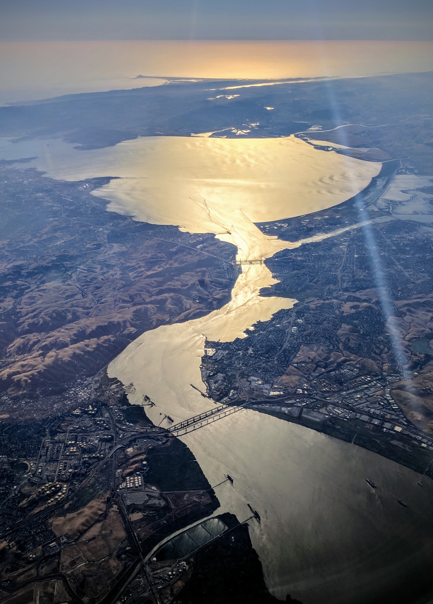
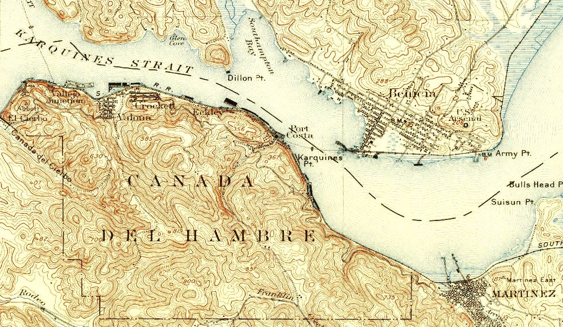
The Carquinez Strait (; Spanish: ''Estrecho de Carquinez'') is a narrow tidal strait in Northern California. It is part of the tidal estuary of the Sacramento and the San Joaquin rivers as they drain into the San Francisco Bay. The strait is long and connects Suisun Bay, which receives the waters of the combined rivers, with San Pablo Bay, a northern extension of the San Francisco Bay. The strait formed in prehistoric times, near the close of one of the past ice ages, when the Central Valley was a vast inland lake. Melting ice from the Sierra Nevada raised the water level while seismic activity created a new outlet to the Pacific Ocean, draining the lake into the ocean and exposing the valley floors. History Andrei Sarna-Wojcicki, a geologist emeritus of the US Geological Survey (USGS), estimates that the Carquinez Strait was likely formed about 640,000 to 700,000 years ago, while much of modern California was emerging from an ice age. The present Sacramento Valley and Sa ... [...More Info...] [...Related Items...] OR: [Wikipedia] [Google] [Baidu] |
Karkin People
The Karkin people (also called ''Los Carquines'' in Spanish) are one of eight Ohlone peoples, indigenous peoples of California. The Karkin people have historically lived in the Carquinez Strait region in the northeast portion of the San Francisco Bay estuary. They spoke the Karkin language, the only documentation of which is a single vocabulary obtained by linguist-missionary Felipe Arroyo de la Cuesta at Mission Dolores in 1821 from Karkin speaker Mariano Antonio Sagnegse. According to de la Cuesta, ''karkin'' means 'to trade.' Although meager, the records of Karkin show that it constituted a distinct branch of Costanoan/Ohlone, strikingly different from the neighboring Chochenyo and other Ohlone languages spoken farther south and across the bay. It is believed that there were about 200 Karkin speakers before colonization. Starting in 1787, some Karkin people began moving to Mission Dolores in present-day San Francisco. In 1804 and 1807, Karkins resisted attempts by Mission Ind ... [...More Info...] [...Related Items...] OR: [Wikipedia] [Google] [Baidu] |
Ice Age
An ice age is a long period of reduction in the temperature of Earth's surface and atmosphere, resulting in the presence or expansion of continental and polar ice sheets and alpine glaciers. Earth's climate alternates between ice ages and greenhouse periods, during which there are no glaciers on the planet. Earth is currently in the Quaternary glaciation. Individual pulses of cold climate within an ice age are termed '' glacial periods'' (or, alternatively, ''glacials, glaciations, glacial stages, stadials, stades'', or colloquially, ''ice ages''), and intermittent warm periods within an ice age are called '' interglacials'' or ''interstadials''. In glaciology, ''ice age'' implies the presence of extensive ice sheets in both northern and southern hemispheres. By this definition, Earth is currently in an interglacial period—the Holocene. The amount of anthropogenic greenhouse gases emitted into Earth's oceans and atmosphere is predicted to prevent the next glacial period for ... [...More Info...] [...Related Items...] OR: [Wikipedia] [Google] [Baidu] |
California Maritime Academy
The California State University Maritime Academy (Cal Maritime or CSU Maritime Academy) is a public university in Vallejo, California. It is one of 23 campuses in the California State University system and the only maritime academy on the United States West Coast. The university offers six different Bachelor's degrees, and one Master's degree. History The California Nautical School was established in 1929, when California State Assembly Bill No. 253 was signed into law by Governor C. C. Young. The bill authorized the creation of the school, the appointment of a Board of Governors to manage the school and the acquisition of a training vessel. The school's mission was "''to give practical and theoretical instruction in navigation, seamanship, steam engines, gas engines, and electricity in order to prepare young men to serve as officers in the American Merchant Marine.''" By 1930, a training vessel and a school site was acquired; the original location of what would become Ca ... [...More Info...] [...Related Items...] OR: [Wikipedia] [Google] [Baidu] |
Indigenous Peoples Of California
The indigenous peoples of California (known as Native Californians) are the indigenous inhabitants who have lived or currently live in the geographic area within the current boundaries of California before and after the arrival of Europeans. With over forty groups seeking to be federally recognized tribes, California has the second-largest Native American population in the United States. The California cultural area does not conform exactly to the state of California's boundaries. Many tribes on the eastern border with Nevada are classified as Great Basin tribes, and some tribes on the Oregon border are classified as Plateau tribes. Tribes in Baja California who do not cross into California are classified as indigenous peoples of Mexico. History Pre-contact Evidence of human occupation of California dates from at least 19,000 years ago. Prior to European contact, indigenous Californians had 500 distinct sub-tribes or groups, each consisting of 50 to 500 individual memb ... [...More Info...] [...Related Items...] OR: [Wikipedia] [Google] [Baidu] |
Ohlone
The Ohlone, formerly known as Costanoans (from Spanish meaning 'coast dweller'), are a Native American people of the Northern California coast. When Spanish explorers and missionaries arrived in the late 18th century, the Ohlone inhabited the area along the coast from San Francisco Bay through Monterey Bay to the lower Salinas Valley. At that time they spoke a variety of related languages. The Ohlone languages make up a sub-family of the Utian language family. Older proposals place Utian within the Penutian language phylum, while newer proposals group it as Yok-Utian. In pre-colonial times, the Ohlone lived in more than 50 distinct landholding groups, and did not view themselves as a single unified group. They lived by hunting, fishing, and gathering, in the typical ethnographic California pattern. The members of these various bands interacted freely with one another. The Ohlone people practiced the Kuksu religion. Prior to the Gold Rush, the northern California r ... [...More Info...] [...Related Items...] OR: [Wikipedia] [Google] [Baidu] |
Mare Island
Mare Island ( Spanish: ''Isla de la Yegua'') is a peninsula in the United States in the city of Vallejo, California, about northeast of San Francisco. The Napa River forms its eastern side as it enters the Carquinez Strait juncture with the east side of San Pablo Bay. Mare Island is considered a peninsula because no full body of water separates this or several other named "islands" from the mainland. Instead, a series of small sloughs cause seasonal water-flows among the so-called islands. Mare Island is the largest of these at about long and a mile wide. History In 1775, Spanish explorer Perez Ayala was the first European to land on what would become Mare Island – he named it ''Isla de la Plana''. This area was part of Rancho Suscol, deeded to General Mariano Guadalupe Vallejo in 1844. It became a waypoint for early settlers. In 1835, whilst traversing the Carquinez Strait, a crude ferry transporting men and livestock capsized in a squall. Among the livestock fear ... [...More Info...] [...Related Items...] OR: [Wikipedia] [Google] [Baidu] |
Napa River
The Napa River is a river approximately long in the U.S. state of California. It drains a famous wine-growing region called the Napa Valley, in the mountains north of the San Francisco Bay. Milliken Creek and Mt. Veeder watersheds are a few of its many tributaries. The river mouth is at Vallejo, where the intertidal zone of fresh and salt waters flow into the Carquinez Strait and the San Pablo Bay. Course The Napa River rises in northwestern Napa County just south of the summit of Mt. St. Helena in the Mayacamas Mountains of the California Coast Ranges. The source begins as seasonal Kimball Canyon Creek in Robert Louis Stevenson State Park at an elevation of which descends the southern slope of Mt. St. Helena to Kimball Canyon Dam. It flows south for 4 miles (6 km), entering the head of the slender Napa Valley north of Calistoga. In the valley, it flows southeast past Calistoga, St Helena, Rutherford, Oakville and through Napa, its head of navigation. Downst ... [...More Info...] [...Related Items...] OR: [Wikipedia] [Google] [Baidu] |
Crockett, California
Crockett (formerly Crockettville) is a census-designated place (CDP) in Contra Costa County, in the East Bay sub-region of the San Francisco Bay Area, California. The population was 3,094 at the 2010 census. It is located 28 miles northeast of San Francisco. Other nearby communities include Port Costa, Martinez, Vallejo, Benicia, Rodeo, Hercules, Pinole and Richmond. History Crockett is located on the Mexican land grant Rancho El Pinole made to Ygnacio Martinez, and is named after Joseph B. Crockett, a judge on the California Supreme Court. The town started when Thomas Edwards Sr. bought of land from Judge Crockett in 1866. Edwards built his home in 1867 and when other settlers arrived, he started the first general store in Crockett. Edwards' home still stands and is known as "The Old Homestead", a California Historical Landmark. Crocketville post office was established in 1883, and the name was changed to Crockett later that year. "Sugar Town" In 1906, an agricultural coope ... [...More Info...] [...Related Items...] OR: [Wikipedia] [Google] [Baidu] |
Port Costa, California
Port Costa is a small village and census-designated place (CDP) in Contra Costa County, California, located in East Bay region of the San Francisco Bay Area. Situated on the southern shore of the Carquinez Strait, the population was 190 at the 2010 census. History Port Costa was founded in 1879 as a landing for the railroad ferry '' Solano'', owned and operated by the Central Pacific Railroad.Images of America: Richmond, by Donald Bastin, Arcadia Publishing (SC), November 2003 This put Port Costa on the main route of the transcontinental railroad. The ''Solano'', later joined by the ''Contra Costa'', carried entire trains across the Carquinez Strait from Benicia to Port Costa, from whence they continued on to the Oakland Pier. Businessman George W. McNear built the Port Costa Warehouses and Dock Company west of the new ferry terminal in 1880. The valley where Port Costa now sits, at one point called Bull Valley, was part of a ranch owned by William Piper. In 1883, McNea ... [...More Info...] [...Related Items...] OR: [Wikipedia] [Google] [Baidu] |
Martinez, California
Martinez ( Spanish: ''Martínez'') is a city and the county seat of Contra Costa County, California, United States, in the East Bay region of the San Francisco Bay Area. Located on the southern shore of the Carquinez Strait, the city's population was 38,290 at the 2020 census. The city is named after Californio ranchero Ygnacio Martínez, having been founded on his Rancho El Pinole. Martinez is known for its historic center and its waterfront. History In 1824, the western side of Martinez, Alhambra Valley was included in the Rancho El Pinole Mexican land grant to Ygnacio Martínez. East of these lands was the Rancho Las Juntas, a grant made to Irish born William Welch in 1844; his land lay between the lands of Martinez and Pacheco. In 1847, Dr. Robert Semple contracted to provide ferry service from Martinez to Benicia, which for many years was the only crossing on the Carquinez Strait. By 1849, Martínez served as a way station for the California Gold Rush. The ... [...More Info...] [...Related Items...] OR: [Wikipedia] [Google] [Baidu] |
Vallejo, California
Vallejo ( ; ) is a city in Solano County, California and the second largest city in the North Bay region of the Bay Area. Located on the shores of San Pablo Bay, the city had a population of 126,090 at the 2020 census. Vallejo is home to the California Maritime Academy, Touro University California and Six Flags Discovery Kingdom. Vallejo is named after Mariano Guadalupe Vallejo, the famed Californio general and statesman. The city was founded in 1851 on General Vallejo's Rancho Suscol to serve as the capital city of California, which it served as from 1852 to 1853, when the Californian government moved to neighboring Benicia, named in honor of General Vallejo's wife Benicia Carrillo de Vallejo. The following year in 1854, authorities founded the Mare Island Naval Shipyard, which defined Vallejo's economy until the turn of the 21st century. History Vallejo was once home of the Coastal Miwok as well as Suisunes and other Patwin Native American tribes. There are ... [...More Info...] [...Related Items...] OR: [Wikipedia] [Google] [Baidu] |
Benicia, California
Benicia ( , ) is a waterside city in Solano County, California, located in the North Bay region of the San Francisco Bay Area. It served as the capital of California for nearly thirteen months from 1853 to 1854. The population was 26,997 at the 2010 United States Census. The city is located along the north bank of the Carquinez Strait. Benicia is just east of Vallejo and across the strait from Martinez. Steve Young, elected in November 2020, is the mayor. History The City of Benicia was founded on May 19, 1847, by Dr. Robert Semple, Thomas O. Larkin, and Comandante General Mariano Guadalupe Vallejo, on land sold to them by General Vallejo in December 1846. It was named for the General's wife, Francisca Benicia Carillo de Vallejo, a member of the Carrillo family of California, a prominent Californio dynasty. The General intended that the city be named "Francisca" after his wife, but this name was dropped when the former city of "Yerba Buena" changed its name to "San F ... [...More Info...] [...Related Items...] OR: [Wikipedia] [Google] [Baidu] |


.jpg)

.png)


.jpg)

.jpg)
