|
Buna River
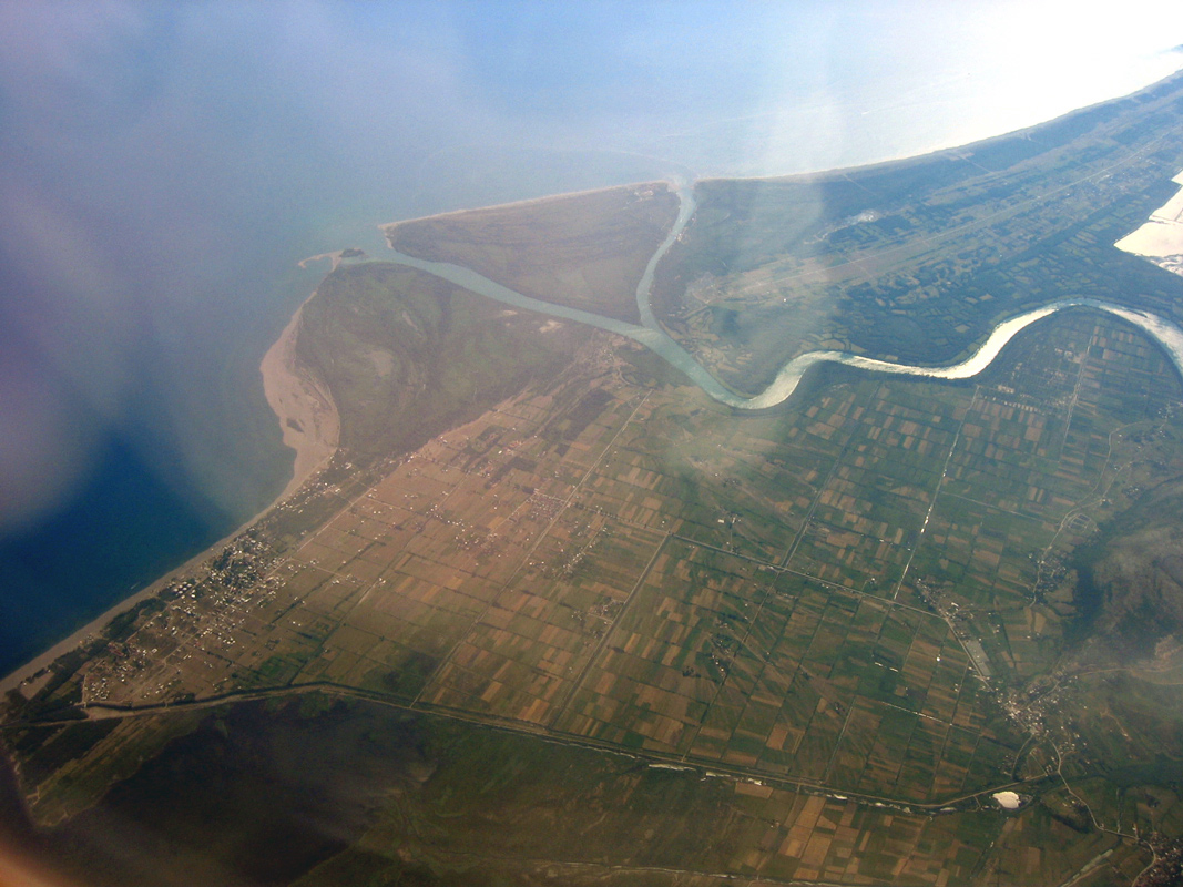
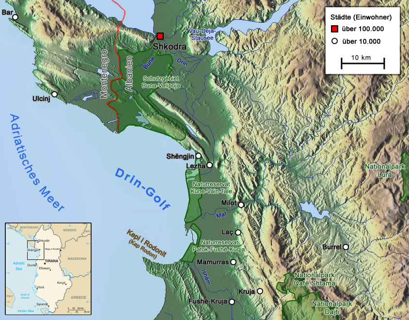
The Bojana ( cnr, Бојана), also known as the Buna ( sq, Bunë), is a river in Albania and Montenegro which flows into the Adriatic Sea. An outflow of Lake Skadar, measured from the source of the lake's longest tributary, the Morača, the Morača-Lake Skadar-Bojana system is long. Etymology The modern Albanian name of the river delivers from Illyrian ''Barbanna'' ''and'' follows Albanian phonetic sound rules. Course The river in Albania The river used to be longer, but due to a rise in the level of Lake Shkodër, the uppermost part of the river is now under the lake's surface. The river initially flows east, but after only few kilometers reaches the city of Shkodër and turns to the south. On the southern outskirts of the city, the river receives its most important tributary, the Great Drin, the greater part of which became its tributary after changing course during a flood in 1858 and now brings more water (352 m³/s) than the Buna itself (320 m³/s). After fl ... [...More Info...] [...Related Items...] OR: [Wikipedia] [Google] [Baidu] |
Shkodër
Shkodër ( , ; sq-definite, Shkodra) is the fifth-most-populous city of the Republic of Albania and the seat of Shkodër County and Shkodër Municipality. The city sprawls across the Plain of Mbishkodra between the southern part of Lake Shkodër and the foothills of the Albanian Alps on the banks of Buna, Drin and Kir. Due to its proximity to the Adriatic Sea, Shkodër is affected by a seasonal Mediterranean climate with continental influences. One of the oldest continuously inhabited cities in the Balkans, Shkodër was founded under the name ''Scodra'' upon the traditional lands of the Illyrian tribes of the Ardiaei and Labeates in the 4th century BCE. It has historically developed on a hill strategically located in the outflow of Lake Shkodër into the Buna River. The Romans annexed the city after the third Illyrian War in 168 BCE, when Gentius was defeated by the Roman force of Anicius Gallus. In the 3rd century CE, Shkodër became the capital of Praevalitana, ... [...More Info...] [...Related Items...] OR: [Wikipedia] [Google] [Baidu] |
Drin River
The Drin (; sq, Drin or ; mk, Дрим, Drim ) is a river in Southern and Southeastern Europe with two distributaries one discharging into the Adriatic Sea and the other one into the Buna River. Its catchment area extends across Albania, Kosovo, Serbia, Greece, Montenegro and North Macedonia. The river and its tributaries form the Gulf of Drin, an ocean basin that encompasses the northern Albanian Adriatic Sea Coast. At long, the Drin is the longest river of Albania of which passes across Albania and the remainder through Kosovo and North Macedonia. It starts at the confluence of its two headwaters, namely the Black Drin and White Drin. It originates in the mountainous northern mountain range, flows westwards through the Albanian Alps and Dukagjin Highlands, and eventually drains into the Adriatic Sea, between Shëngjin and Durrës. Numerous lakes and reservoirs are formed by the river or flow into it such as the Fierza Lake and Koman Lake. Located in the B ... [...More Info...] [...Related Items...] OR: [Wikipedia] [Google] [Baidu] |
Franc Jozeph Island
Franz Jozeph Island (or ''Franz Josef'', ''Franc Jozeph'', etc.) ( sq, Ishulli i Franc Jozefit) is an island located at the mouth of the Buna River in Albania. The island is made up of rich alluvial soil and becomes a peninsula depending on the size of the river's flow. This island is an important nesting ground for many seabirds, especially the family Ardeidae. The island is low ground covered with a sandy seashore and dominated by alder trees. The trees are 75 years of age and reach a height of . The island receives few foreign tourists and attracts for its quietness. The name was given to the island by Austrian cartographers in 1870. It is believed that the name was chosen in honor of the Emperor Franz Joseph I of Austria Franz Joseph I or Francis Joseph I (german: Franz Joseph Karl, hu, Ferenc József Károly, 18 August 1830 – 21 November 1916) was Emperor of Austria, King of Hungary, and the other states of the Habsburg monarchy from 2 December 1848 until .... Fra ... [...More Info...] [...Related Items...] OR: [Wikipedia] [Google] [Baidu] |
Serbian Language
Serbian (, ) is the standardized variety of the Serbo-Croatian language mainly used by Serbs. It is the official and national language of Serbia, one of the three official languages of Bosnia and Herzegovina and co-official in Montenegro and Kosovo. It is a recognized minority language in Croatia, North Macedonia, Romania, Hungary, Slovakia, and the Czech Republic. Standard Serbian is based on the most widespread dialect of Serbo-Croatian, Shtokavian (more specifically on the dialects of Šumadija-Vojvodina and Eastern Herzegovina), which is also the basis of standard Croatian, Bosnian, and Montenegrin varieties and therefore the Declaration on the Common Language of Croats, Bosniaks, Serbs, and Montenegrins was issued in 2017. The other dialect spoken by Serbs is Torlakian in southeastern Serbia, which is transitional to Macedonian and Bulgarian. Serbian is practically the only European standard language whose speakers are fully functionally digraphic, using both C ... [...More Info...] [...Related Items...] OR: [Wikipedia] [Google] [Baidu] |
Turkish Language
Turkish ( , ), also referred to as Turkish of Turkey (''Türkiye Türkçesi''), is the most widely spoken of the Turkic languages, with around 80 to 90 million speakers. It is the national language of Turkey and Northern Cyprus. Significant smaller groups of Turkish speakers also exist in Iraq, Syria, Germany, Austria, Bulgaria, North Macedonia, Greece, the Caucasus, and other parts of Europe and Central Asia. Cyprus has requested the European Union to add Turkish as an official language, even though Turkey is not a member state. Turkish is the 13th most spoken language in the world. To the west, the influence of Ottoman Turkish—the variety of the Turkish language that was used as the administrative and literary language of the Ottoman Empire—spread as the Ottoman Empire expanded. In 1928, as one of Atatürk's Reforms in the early years of the Republic of Turkey, the Ottoman Turkish alphabet was replaced with a Latin alphabet. The distinctive characteristics of the Tu ... [...More Info...] [...Related Items...] OR: [Wikipedia] [Google] [Baidu] |
Ada Bojana
Ada Bojana ( cnr, Ада Бојана, ; Albanian: Ishulli i Bunës) is an island in the Ulcinj Municipality in Montenegro. The name ''Ada'' means river island in Serbo-Croatian. The island is created by a river delta of the Bojana River. It is located on the southernmost tip of Montenegro, with the Bojana river separating it from Pulaj and Velipojë in the Albanian territory. The island is of triangular shape, bordered from two sides by the Bojana river and by the Adriatic Sea from the southwest. It has an area of 4.8 square km. It is a popular tourist destination, with long sandy beach with traditional seafood restaurants. Ada Bojana offers kitesurfing and windsurfing locations on the Adriatic Coast due to the strong cross onshore winds during summer afternoons. Ada Bojana's main income is from Camping. ''The New York Times ''The New York Times'' (''the Times'', ''NYT'', or the Gray Lady) is a daily newspaper based in New York City with a worldwide readership r ... [...More Info...] [...Related Items...] OR: [Wikipedia] [Google] [Baidu] |
Adriatic
The Adriatic Sea () is a body of water separating the Italian Peninsula from the Balkan Peninsula. The Adriatic is the northernmost arm of the Mediterranean Sea, extending from the Strait of Otranto (where it connects to the Ionian Sea) to the northwest and the Po Valley. The countries with coasts on the Adriatic are Albania, Bosnia and Herzegovina, Croatia, Italy, Montenegro, and Slovenia. The Adriatic contains more than 1,300 islands, mostly located along the Croatian part of its eastern coast. It is divided into three basins, the northern being the shallowest and the southern being the deepest, with a maximum depth of . The Otranto Sill, an underwater ridge, is located at the border between the Adriatic and Ionian Seas. The prevailing currents flow counterclockwise from the Strait of Otranto, along the eastern coast and back to the strait along the western (Italian) coast. Tidal movements in the Adriatic are slight, although larger amplitudes are known to occur occasionall ... [...More Info...] [...Related Items...] OR: [Wikipedia] [Google] [Baidu] |
Velika Plaža
Velika Plaža ( sq, Plazhi i Madh; sr-cyrl, Велика Плажа, ;, lit. "Big Beach") is a beach in Ulcinj Municipality, Montenegro. It stretches from Port Milena in Ulcinj to the Bojana River, which separates it from Ada Bojana. Visit Montenegro Overview The sand beach's length is 12,000 meters (8 miles), one of the longest in Europe and the longest in Montenegro. The New York Times included Velika Plaža and Montenegro's South Coast (including and[...More Info...] [...Related Items...] OR: [Wikipedia] [Google] [Baidu] |
Ulcinj
Ulcinj ( cyrl, Улцињ, ; ) is a town on the southern coast of Montenegro and the capital of Ulcinj Municipality. It has an urban population of 10,707 (2011), the majority being Albanians. As one of the oldest settlements in the Adriatic coast, it was founded in 5th century BC. It was captured by the Romans in 163 BC from the Illyrians. With the division of the Roman Empire, it became part of the Byzantine Empire. It was known as a base for piracy. During the Middle Ages it was under South Slavic rule for a few centuries. In 1405 it became part of the Republic of Venice. In 1571 Ulcinj was conquered by the Ottoman Empire with the aid of North African corsairs after the Battle of Lepanto. The town was renamed ''Ülgün'' and gradually became a Muslim-majority settlement. Under the Ottomans, numerous oriental-style hammams, mosques, and clock towers were built. Ulcinj remained a den of piracy until this was finally put to an end by Mehmed Pasha Bushati. In 1673, the self-pro ... [...More Info...] [...Related Items...] OR: [Wikipedia] [Google] [Baidu] |
Reč
Reč ( cyrl, Реч; sq, Reç) is a small town in the municipality of Ulcinj, southeastern Montenegro.Reč is mentioned in 1413 in the Scutarias taxable income part of the Albanian (''arbanas'') ''katun'' (semi-nomadic pastoral community) of Gjon Kereçi (''Kereçi'' in the original) In recent times, many locals have migrated, notably to the United States. The area is a prime site for agricultural land, hunting, and fishing Fishing is the activity of trying to catch fish. Fish are often caught as wildlife from the natural environment, but may also be caught from fish stocking, stocked bodies of water such as fish pond, ponds, canals, park wetlands and reservoirs. .... Reč is divided into two sections: *Reč *Kodre Dakaj ( sq, Kodrat e Reçit) Family names Djonovic, Dukagjini, Dushaj, Gazivoda, Gjoni / Gjonaj, Kina / Kinic, Mirdita, Selca / Selcanin, Shabani, Zadrima, Zagreda, Lotaj. Demographics The population of Reč between 1948 and 2003 was as follows: *1948 – 221 ... [...More Info...] [...Related Items...] OR: [Wikipedia] [Google] [Baidu] |
Lake Šas
Lake Šas ( sr, Шаско jезеро, Šasko jezero; sq, Liqeni i Shasit) is a lake located north-east of Ulcinj, near the village of Šas, in Montenegro. It is bordered geographically by Briska Gora (Mali i Brisë) to the southwest, Fraskanjelsko Polje (Këneta e Fraskanjellit) to the east, Ambulsko Brdo (Mali i Amullit) and Šasko Brdo (Mali i Shasit) to the northeast and the Brisko Polje (Fusha e Brisë) to the northwest. Geopolitically, Briska Gora lies to the southwest of Lake Šas, Fraskanjel lies to the east and Ambula and Šas to the northeast. The area of this lake is 5.5 km², it is 3.2 km long and 1.5 km wide. The max depth is 7.8 m. The shore of the lake is about 8.6 km. Montenegro Travel It is also known as ''Little Lake Skadar'' because it has the same flora and fauna as |


