Paleoseismology on:
[Wikipedia]
[Google]
[Amazon]


 Paleoseismology looks at


Paleoseismicity.org - Online platform for paleoseismologists
TERPRO Commission, International Union for Quaternary Research Historical geology Fields of seismology


 Paleoseismology looks at
 geologic
Geology () is a branch of natural science concerned with Earth and other astronomical objects, the features or rocks of which it is composed, and the processes by which they change over time. Modern geology significantly overlaps all other E ...
sediment
Sediment is a naturally occurring material that is broken down by processes of weathering and erosion, and is subsequently transported by the action of wind, water, or ice or by the force of gravity acting on the particles. For example, sand ...
s and rocks, for signs of ancient earthquake
An earthquake (also known as a quake, tremor or temblor) is the shaking of the surface of the Earth resulting from a sudden release of energy in the Earth's lithosphere that creates seismic waves. Earthquakes can range in intensity, fr ...
s. It is used to supplement seismic monitoring, for the calculation of seismic hazard
A seismic hazard is the probability that an earthquake will occur in a given geographic area, within a given window of time, and with ground motion intensity exceeding a given threshold. With a hazard thus estimated, risk can be assessed and incl ...
. Paleoseismology is usually restricted to geologic regimes that have undergone continuous sediment creation for the last few thousand years, such as swamp
A swamp is a forested wetland.Keddy, P.A. 2010. Wetland Ecology: Principles and Conservation (2nd edition). Cambridge University Press, Cambridge, UK. 497 p. Swamps are considered to be transition zones because both land and water play a role in ...
s, lake
A lake is an area filled with water, localized in a basin, surrounded by land, and distinct from any river or other outlet that serves to feed or drain the lake. Lakes lie on land and are not part of the ocean, although, like the much large ...
s, river
A river is a natural flowing watercourse, usually freshwater, flowing towards an ocean, sea, lake or another river. In some cases, a river flows into the ground and becomes dry at the end of its course without reaching another body of ...
beds and shorelines.
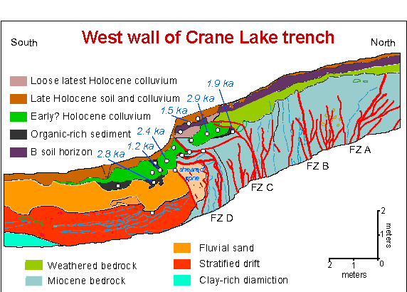
In this typical example, a trench is dug in an active sedimentation regime. Evidence of thrust fault
A thrust fault is a break in the Earth's crust, across which older rocks are pushed above younger rocks.
Thrust geometry and nomenclature
Reverse faults
A thrust fault is a type of reverse fault that has a dip of 45 degrees or less.
If ...
ing can be seen in the walls of the trench. It becomes a matter of deducting the relative age of each fault, by cross-cutting patterns. The faults can be dated in absolute terms, if there is dateable carbon, or human artifacts.
Many notable discoveries have been made using the techniques of paleoseismology. For example, there is a common misconception that having many smaller earthquakes can somehow 'relieve' a major fault such as the San Andreas Fault
The San Andreas Fault is a continental transform fault that extends roughly through California. It forms the tectonic boundary between the Pacific Plate and the North American Plate, and its motion is right-lateral strike-slip (horizontal) ...
, and reduce the chance of a major earthquake. It is now known (using paleoseismology) that nearly all the movement of the fault takes place with extremely large earthquakes. All of these seismic events (with a moment magnitude of over 8), leave some sort of trace in the sedimentation record.
Another famous example involves the megathrust earthquake
Megathrust earthquakes occur at convergent plate boundaries, where one tectonic plate is forced underneath another. The earthquakes are caused by slip along the thrust fault that forms the contact between the two plates. These interplate earthqu ...
s of the Pacific Northwest. It was thought for some time that there was low seismic hazard in the region because relatively few modern earthquakes have been recorded. It was thought that the Cascadia subduction zone
The Cascadia subduction zone is a convergent plate boundary that stretches from northern Vancouver Island in Canada to Northern California in the United States. It is a very long, sloping subduction zone where the Explorer, Juan de Fuc ...
was merely sliding in a benign manner.
All of these comforting notions were shattered by paleoseismology studies showing evidence of extremely large earthquakes (the most recent being in 1700), along with historical tsunami
A tsunami ( ; from ja, 津波, lit=harbour wave, ) is a series of waves in a water body caused by the displacement of a large volume of water, generally in an ocean or a large lake. Earthquakes, volcanic eruptions and other underwater exp ...
records. In effect, the subduction
Subduction is a geological process in which the oceanic lithosphere is recycled into the Earth's mantle at convergent boundaries. Where the oceanic lithosphere of a tectonic plate converges with the less dense lithosphere of a second plate, ...
zone under British Columbia, Washington, Oregon, and far northern California, is perfectly normal, being extremely hazardous in the long term, with the capability of generating coastal tsunamis of several hundred feet in height at the coast. These are caused by the interface between the subducted sea floor stressing the overlaying coastal soils in compression. Periodically a slip will occur which causes the coastal portion to reduce in elevation and thrust toward the west, leading to tsunamis in the central and eastern north Pacific Ocean (with several hours of warning) and a reflux of water toward the coastal shore, with little time for residents to escape.
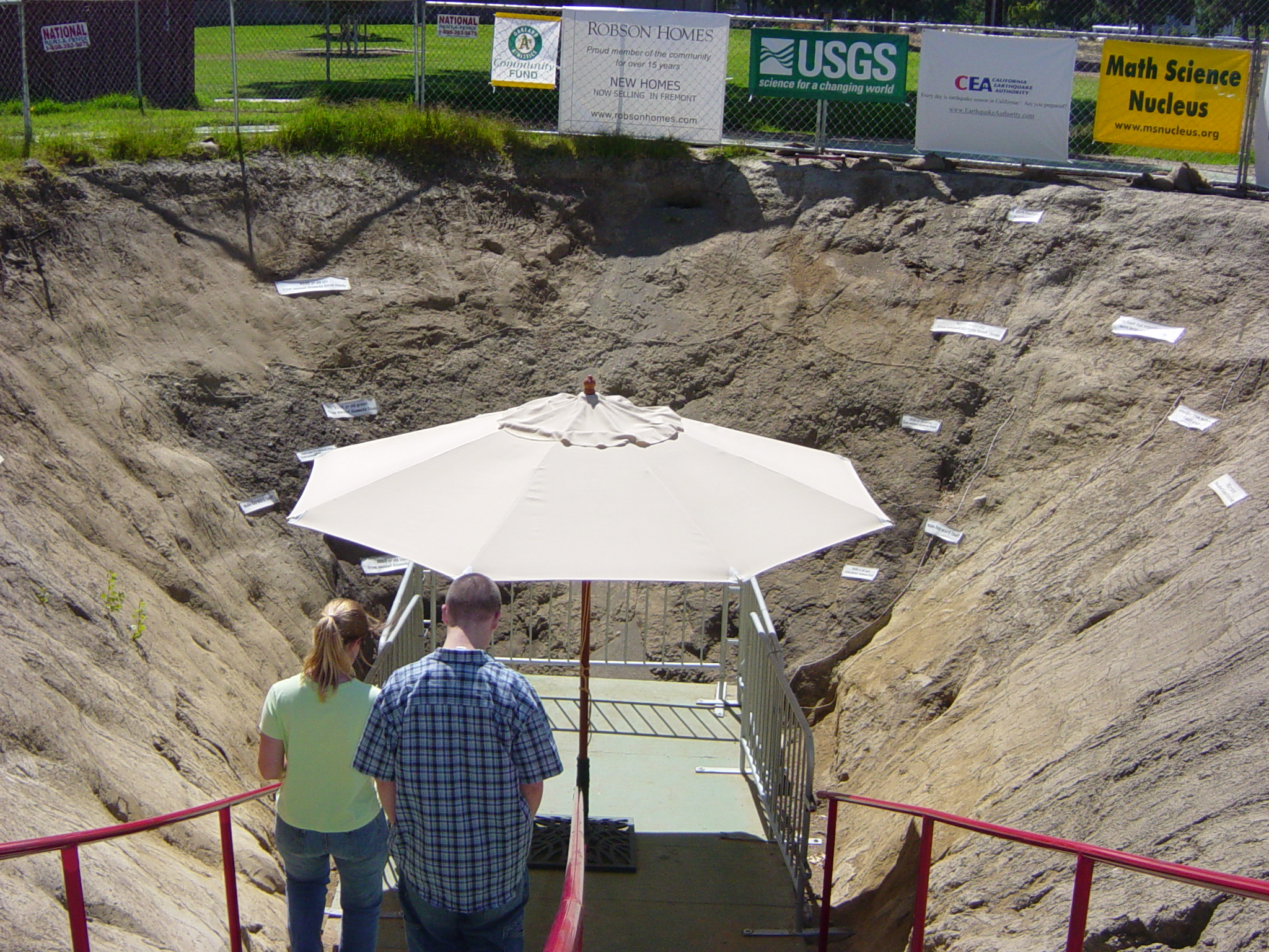
An educational excavation


Paleoseismic trenching
Paleoseismic investigations are commonly performed through trenching studies in which a trench is dug and a geologist logs the geological attributes of the rock layers. Trenching studies are especially relevant to seismically active regions, such as many parts of California.See also
* Archaeoseismology * Paleotempestology * SeismiteReferences
Sources
*James P. McCalpin (2009) Paleoseismology (2nd Edition), Academic Press, , *James P. McCalpin (1996) Paleoseismology, Elsevier, {{ISBN, 0-12-481826-9External links
Paleoseismicity.org - Online platform for paleoseismologists
TERPRO Commission, International Union for Quaternary Research Historical geology Fields of seismology