Timms Hill on:
[Wikipedia]
[Google]
[Amazon]
Timms Hill or Timm's Hill is the highest natural point in the U.S. state of
Timm's Hill Trail Web Site
/ref> a
Wisconsin
Wisconsin () is a state in the upper Midwestern United States. Wisconsin is the 25th-largest state by total area and the 20th-most populous. It is bordered by Minnesota to the west, Iowa to the southwest, Illinois to the south, Lake M ...
and is located in north-central Wisconsin in Timms Hill County Park in the Town of Hill in Price County. After being surveyed by Quentin Stevens of Ogema Telephone Co in 1962, Timms Hill was discovered to have an elevation of . It is less than south of Highway 86, about midway between Ogema and Spirit and about west of Tomahawk.
Description
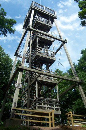
Timms Hill is located in Timms Hill County Park. A public lookout tower is atop the hill. Visible to the southeast is Rib Mountain (elev. 1,924 ft, 586 m), 44 miles away by line of sight. The Timms Hill Trail connects to the Ice Age Trail,/ref> a
National Scenic Trail
The National Trails System is a series of trails in the United States designated "to promote the preservation of, public access to, travel within, and enjoyment and appreciation of the open-air, outdoor areas and historic resources of the Nati ...
stretching across glacial terrain in Wisconsin.
See also
*List of U.S. states by elevation
This list includes the topographic elevations of each of the 50 U.S. states, the District of Columbia, and the U.S. territories.
The elevation of a geographic area may be stated in several ways. These include:
#The maximum elevation of the a ...
References
External links
* * * * {{Subject bar , portal2= Mountains , portal3= United States Hills of Wisconsin Landmarks in Wisconsin Landforms of Price County, Wisconsin Highest points of U.S. states