Swansea Urban Area on:
[Wikipedia]
[Google]
[Amazon]
The Swansea Urban Area or Swansea Built-up Area is an area of land in south 
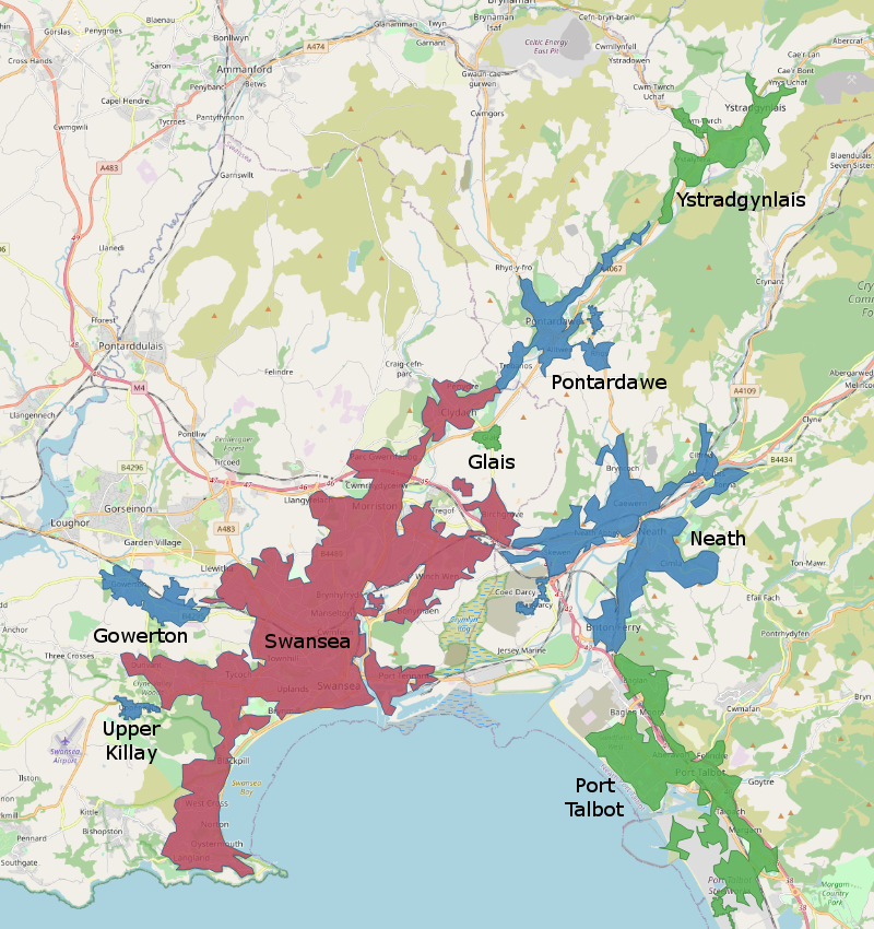
ONS map, showing urban areas in part of South WalesOffice for National Statistics: Census 2001, Key Statistics for urban areas
Geography of Swansea Urban areas of Wales Demographics of Wales
Wales
Wales ( ) is a Countries of the United Kingdom, country that is part of the United Kingdom. It is bordered by the Irish Sea to the north and west, England to the England–Wales border, east, the Bristol Channel to the south, and the Celtic ...
, defined by the Office for National Statistics
The Office for National Statistics (ONS; ) is the executive office of the UK Statistics Authority, a non-ministerial department which reports directly to the Parliament of the United Kingdom, UK Parliament.
Overview
The ONS is responsible fo ...
for population monitoring purposes. It is an urban conurbation
A conurbation is a region consisting of a number of metropolises, cities, large towns, and other urban areas which, through population growth and physical expansion, have merged to form one continuous urban or industrially developed area. In most ...
and is not coterminous with the City and County of Swansea
Swansea ( ; ) is a coastal City status in the United Kingdom, city and the List of urban areas in the United Kingdom, second-largest city of Wales. It forms a Principal areas of Wales, principal area, officially known as the City and County of ...
. It consists of the urban area centred on Swansea city centre; the Swansea Valley including Clydach, Ystradgynlais and Pontardawe; and includes Neath
Neath (; ) is a market town and Community (Wales), community situated in the Neath Port Talbot, Neath Port Talbot County Borough, Wales. The town had a population of 50,658 in 2011. The community of the parish of Neath had a population of 19,2 ...
and Port Talbot
Port Talbot (, ) is a town and community (Wales), community in the county borough of Neath Port Talbot, Wales, situated on the east side of Swansea Bay, approximately from Swansea. The Port Talbot Steelworks covers a large area of land which d ...
which are outside the county boundaries, but excludes the urban area of Gorseinon within the county boundaries.
The total population of the area in 2011 was 300,352 making it the 3rd largest in Wales, the 24th largest conurbation in England and Wales and the 27th largest in the United Kingdom. This was an increase of 11% from the 2001 figure of 270,506. Most of the increase was due to Ystradgynlais, Gowerton, Upper Killay and Glais becoming part of the urban area.
Subdivisions
The ONS provides sub-division statistics for the Swansea Urban Area Notes: *Gowerton was included under the Swansea subdivision for the 2001 census. *Ystradgynlais was not part of the Swansea urban area until the 2011 censusSee also
* List of conurbations in the United KingdomReferences
{{reflistExternal links
ONS map, showing urban areas in part of South Wales
Geography of Swansea Urban areas of Wales Demographics of Wales