Sheffield Outer Ring Road on:
[Wikipedia]
[Google]
[Amazon]
 Sheffield Outer Ring Road is one of two main routes circumventing
Sheffield Replanned
Sheffield City Council, 1948 Roads in Sheffield Streets in Sheffield Ring roads in the United Kingdom
 Sheffield Outer Ring Road is one of two main routes circumventing
 Sheffield
Sheffield is a city in South Yorkshire, England, situated south of Leeds and east of Manchester. The city is the administrative centre of the City of Sheffield. It is historically part of the West Riding of Yorkshire and some of its so ...
, England, a partial ring around Sheffield City Centre
Sheffield City Centre (referred to locally as simply Town) is a district of the Sheffield, City of Sheffield and is covered partly by the City ward, Sheffield, City ward of the City of Sheffield. It includes the area that is within a radius of ...
and its suburbs
A suburb (more broadly suburban area) is an area within a metropolitan area. They are oftentimes where most of a metropolitan areas jobs are located with some being predominantly residential. They can either be denser or less densely populated ...
.
Route
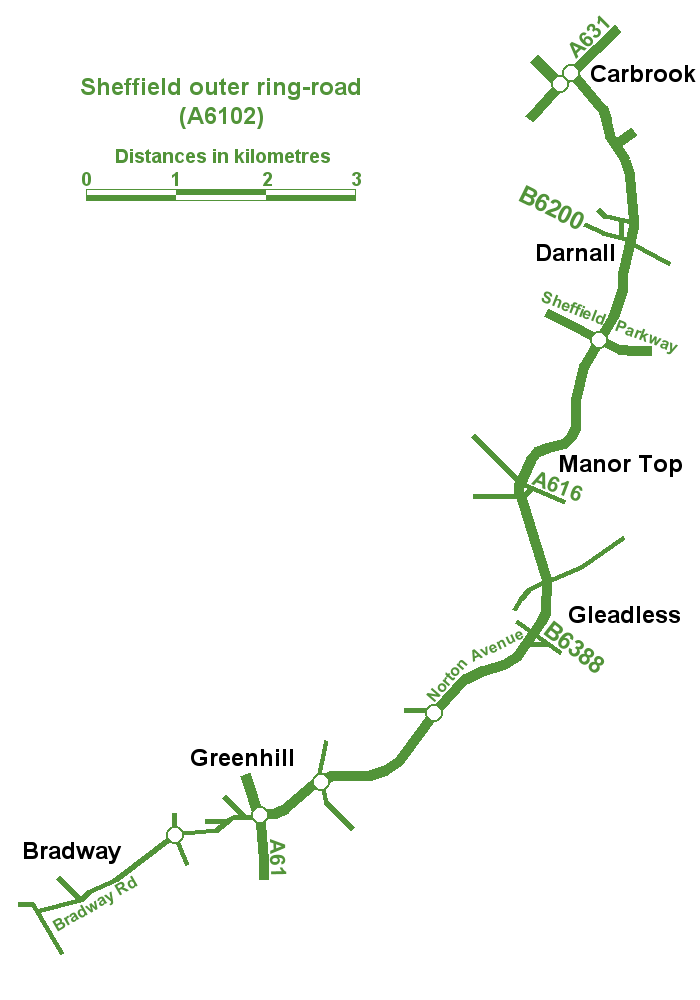
It begins in Bradway as the B6054 Bradway Road, progressing anticlockwise as Greenhill Parkway, crossing the A61 Meadowhead/ Chesterfield Road South into the A6102 Bochum Parkway, which turns north, passing through Norton. Heading east again, at Lightwood, it becomes the dual-carriageway A6102 Norton Avenue. After intersecting with White Lane at Gleadless Townend and passing Gleadless Townend Supertram stop, it becomes Ridgeway Road. It carries on northwards to intersect with City Road at Manor Top, where it becomes Prince of Wales Road, before traversing the Manor and Wybourn Estates, passing to the west of theAdvanced Manufacturing Park
The Advanced Manufacturing Park (AMP) is a manufacturing technology park in Waverley, Rotherham, South Yorkshire, England. It was partly funded by the European Regional Development Fund, with Yorkshire Forward, and developed by Harworth Gro ...
and meeting the A57 Sheffield Parkway (which is grade separated
In civil engineering (more specifically highway engineering), grade separation is a method of aligning a junction of two or more surface transport axes at different heights ( grades) so that they will not disrupt the traffic flow on other tr ...
). Still as Prince of Wales Road, it passes to the west of Sheffield Business Park, Tinsley Park Golf Course and the former Sheffield City Airport through the suburbs of Darnall and Attercliffe. It now heads north-west now named Greenland Road and passes over the River Don and to the North-east of Sheffield Arena
Sheffield Arena, known for sponsorship purposes as Utilita Arena Sheffield, is a multi-purpose arena located in Sheffield, England. It is situated near Meadowhall Centre, Meadowhall and lies between Sheffield city centre and Rotherham town centr ...
and Don Valley Stadium
Don Valley Stadium, England, was a stadium in Sheffield, South Yorkshire, completed in 1990, and hosted the 1991 World Student Games. It was named after the nearby River Don. The stadium was demolished in 2013.
The stadium and facilities were ...
. There are junctions here with the A631 Shepcote Lane and Attercliffe Common (where the ring road terminates as Broughton Lane) heading northeast to the M1 at Junction 34, Tinsley Viaduct
Tinsley Viaduct is a two-tier road bridge in Sheffield, England; it was the first of its kind in the United Kingdom. It carries the M1 and the A631 for a distance of over the Don Valley, from Tinsley to Wincobank, also crossing the Sheffi ...
.
Although some claim this to be the end of the ring road, a left turn, onto Attercliffe Common and a right turn after half a mile lead onto Janson Street and Hawke Street, which may also be considered part of the ring road. Heading west, this passes through the suburb of Grimesthorpe as Upwell Street, Owler Lane and Rushby Street, top form a junction with Barnsley Road and Firth Park
Firth Park ward—which includes the districts of Firth Park, Longley, Parson Cross and parts of Wincobank—is one of the 28 electoral wards in City of Sheffield, England located in the northern part of the city and covering an area ...
Road by the large Northern General Hospital
The Northern General Hospital is a large teaching hospital and Major Trauma Centre in Sheffield, England. Its departments include accident and emergency for adults, with children being treated at the Sheffield Children's Hospital on Western Ba ...
campus, where the ring road carries on as Herries Road to A61 Penistone Road in Hillsborough, where it fully terminates.
Extension
Due to thetopography
Topography is the study of the forms and features of land surfaces. The topography of an area may refer to the landforms and features themselves, or a description or depiction in maps.
Topography is a field of geoscience and planetary sci ...
of the region, there is no western section to the outer ring road, although it was originally planned to complete a full circuit. Some recent ideas to complete the western section have been mooted to relieve congestion in the south-west, possibly through Stannington, west of Fulwood and crossing Ringinglow Road, to intersect with Ecclesall Road South, where it would carry on as an upgraded Abbey Lane to Chesterfield Road.{{citation needed, date=February 2023
References
Sheffield Replanned
Sheffield City Council, 1948 Roads in Sheffield Streets in Sheffield Ring roads in the United Kingdom