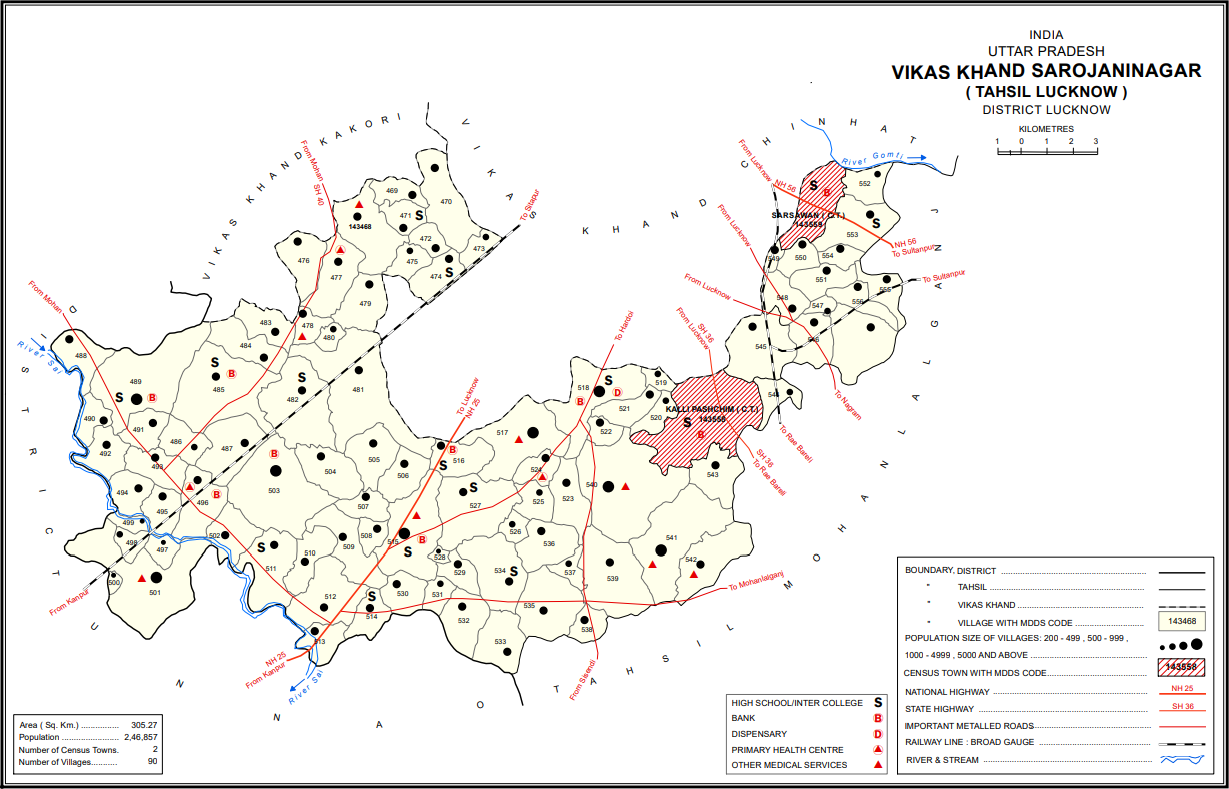
Sarojaninagar Block Map on:
[Wikipedia]
[Google]
[Amazon]
 Sarojininagar, also spelled Sarojani Nagar, is a
 Sarojininagar, also spelled Sarojani Nagar, is a
 community development block
In India, a community development block (CD block) or simply Block is a sub-division of District, administratively earmarked for planning and development. In tribal areas, similar sub-divisions are called tribal development blocks (TD blocks). T ...
in Lucknow district, Uttar Pradesh
Uttar Pradesh ( ; UP) is a States and union territories of India, state in North India, northern India. With over 241 million inhabitants, it is the List of states and union territories of India by population, most populated state in In ...
, India
India, officially the Republic of India, is a country in South Asia. It is the List of countries and dependencies by area, seventh-largest country by area; the List of countries by population (United Nations), most populous country since ...
. It is part of the tehsil
A tehsil (, also known as tahsil, taluk, or taluka () is a local unit of administrative division in India and Pakistan. It is a subdistrict of the area within a Zila (country subdivision), district including the designated populated place that ser ...
of Lucknow
Lucknow () is the List of state and union territory capitals in India, capital and the largest city of the List of state and union territory capitals in India, Indian state of Uttar Pradesh and it is the administrative headquarters of the epon ...
and it includes 90 villages. As of 2011, its population was 224,045, in 40,923 households.
Sarojininagar is also the name of two wards of Lucknow, together making up 32 mohalla
is an Arabic word variously translated as district, quarter, ward, or neighborhood in many parts of the Arab world, the Balkans, Western Asia, the Indian subcontinent, and nearby nations.
History
Historically, mahallas were autonomous social inst ...
s of the city.
Demographics
As of 2011, thesex ratio
A sex ratio is the ratio of males to females in a population. As explained by Fisher's principle, for evolutionary reasons this is typically about 1:1 in species which reproduce sexually. However, many species deviate from an even sex ratio, ei ...
of Sarojininagar block is 903 females for every 1000 males, with 53% of block residents (117,745) being male and 47% (106,300) being female. The sex ratio in the 0-6 age group was 920. Members of scheduled castes made up 37.2% of the Sarojininagar block population, and members of scheduled tribes made up 0.11%. The literacy rate
Literacy is the ability to read and write, while illiteracy refers to an inability to read and write. Some researchers suggest that the study of "literacy" as a concept can be divided into two periods: the period before 1950, when literacy was ...
of Sarojininagar block in 2011 was 73.0% (81.1% among males and 64.1% among females).
In 2011, Sarojininagar block's workforce consisted of 74,661 people (33.3% of the overall block population). More men (59,508, or 50.5%) were workers than women (15,153, or 14.3%). A plurality of workers were employed in agriculture
Agriculture encompasses crop and livestock production, aquaculture, and forestry for food and non-food products. Agriculture was a key factor in the rise of sedentary human civilization, whereby farming of domesticated species created ...
— 23.53% were cultivators who owned or leased their own land, and another 26.26% were agricultural labourers who worked someone else's land for wages. A further 6.25% were household industry workers, and the remaining 43.96% were other workers.
Demographic history
The 1961 census recorded Sarojininagar block as having a total population of 107,880 people (57,375 male and 50,505 female), in 22,327 households and 22,022 physical houses. The 1981 census recorded Sarojininagar as the most heavily industrialised of Lucknow district's development blocks, with 56 registered industrial firms. At the time, it comprised 106 villages, including 94 gram sabhas and 13nyaya panchayat
A Nyaya panchayat () is a system of dispute resolution at the village level in the panchayati raj system of India.
Current movements in India
Legislation to formalize these bodies and bring them within the ambit of organised justice in India ...
s.
Land use
Sarojininagar block covers an area of 30,526.9hectare
The hectare (; SI symbol: ha) is a non-SI metric unit of area equal to a square with 100-metre sides (1 hm2), that is, square metres (), and is primarily used in the measurement of land. There are 100 hectares in one square kilometre. ...
s, of which 58.2% (17,770.8 hectares, not counting fallow
Fallow is a farming technique in which arable land is left without sowing for one or more vegetative cycles. The goal of fallowing is to allow the land to recover and store Organic compound, organic matter while retaining moisture and disrupting ...
land) is farmland as of 2011. Most of this farmland is irrigated
Irrigation (also referred to as watering of plants) is the practice of applying controlled amounts of water to land to help grow crops, landscape plants, and lawns. Irrigation has been a key aspect of agriculture for over 5,000 years and has be ...
: 16,054.8 hectares, or 90.3% as of the same year. Irrigation is mostly by tanks or lakes. Areas under non-agricultural use made up 3,537.4 hectares as of 2011, or about 11.6% of the total land area. Land considered barren and unsuitable for cultivation covered 1219 hectares. As of 2011, 1,027 hectares in this block are covered by forest
A forest is an ecosystem characterized by a dense ecological community, community of trees. Hundreds of definitions of forest are used throughout the world, incorporating factors such as tree density, tree height, land use, legal standing, ...
s.
Villages
Sarojininagar block comprises the following 90 villages:References
{{Reflist Lucknow district Lucknow division