Kaʻula on:
[Wikipedia]
[Google]
[Amazon]
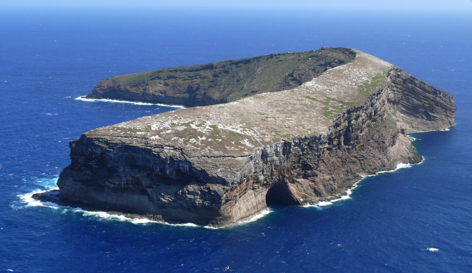
 Kaʻula Island, also called Kaʻula Rock, is a small, crescent-shaped island in the
 Kaula is uninhabited, but fishermen and
 Underwater Photos from Five Fathom Pinnacle
/ref>
Offshore Islet Restoration Committee, KaulaKaula IslandNautical Chart Containing Kaula IslandKaula Rock Photos
Photographs of Kaula Island, May 2008 * {{DEFAULTSORT:Kaula Niihau Geography of Kauai County, Hawaii Hawaiian–Emperor seamount chain Tuff cones Uninhabited islands of Hawaii Volcanoes of Hawaii Pliocene volcanoes Neogene Oceania Cenozoic Hawaii Islands of Hawaii
Hawaiian Islands
The Hawaiian Islands ( haw, Nā Mokupuni o Hawai‘i) are an archipelago of eight major islands, several atolls, and numerous smaller islets in the North Pacific Ocean, extending some from the island of Hawaii in the south to northernmost ...
.
Mythology
In the legend of Papa and Wākea, Kaula is the seventh-born child.Geography
It is located west-southwest of Kawaihoa Point on Niihau, and about west ofHonolulu
Honolulu (; ) is the capital and largest city of the U.S. state of Hawaii, which is in the Pacific Ocean. It is an unincorporated county seat of the consolidated City and County of Honolulu, situated along the southeast coast of the isla ...
. The island is the top of a volcanic tuff cone that rests on top of a larger, submerged shield volcano
A shield volcano is a type of volcano named for its low profile, resembling a warrior's shield lying on the ground. It is formed by the eruption of highly fluid (low viscosity) lava, which travels farther and forms thinner flows than the more vi ...
. At its highest point, the island reaches a height of . The ocean has carved large sea cliffs on the sides of the island. There is a large cave on the northwest side of the island called Kahalauaola (Shark Cave).
The United States Census Bureau
The United States Census Bureau (USCB), officially the Bureau of the Census, is a principal agency of the U.S. Federal Statistical System, responsible for producing data about the American people and economy. The Census Bureau is part of th ...
defines Kaula as Census Tract
A census tract, census area, census district or meshblock is a geographic region defined for the purpose of taking a census. Sometimes these coincide with the limits of cities, towns or other administrative areas and several tracts commonly exis ...
411 of Kauai County, Hawaii. The 2000 census showed that the uninhabited island had a land area of . Because of erosion
Erosion is the action of surface processes (such as water flow or wind) that removes soil, rock, or dissolved material from one location on the Earth's crust, and then transports it to another location where it is deposited. Erosion is d ...
, the island is slowly shrinking.
Kaʻula, which he spelled as "Tahoora", was one of the first five islands sighted by Captain James Cook in 1778.
Lighthouse
Alighthouse
A lighthouse is a tower, building, or other type of physical structure designed to emit light from a system of lamps and lenses and to serve as a beacon for navigational aid, for maritime pilots at sea or on inland waterways.
Lighthouses m ...
was completed on the island in 1932 by the United States Lighthouse Service, which became part of the United States Coast Guard
The United States Coast Guard (USCG) is the maritime security, search and rescue, and law enforcement service branch of the United States Armed Forces and one of the country's eight uniformed services. The service is a maritime, military, m ...
in 1939. The lighthouse remained in operation through 1947.
Military use
The island has been used as a bombing range by theUnited States Navy
The United States Navy (USN) is the maritime service branch of the United States Armed Forces and one of the eight uniformed services of the United States. It is the largest and most powerful navy in the world, with the estimated tonnage ...
since at least 1952. Inert ordnance is currently used, although live explosive ordnance has been used in the past. There is a risk of unexploded ordnance on the island. Permission from the U.S. Navy is required to land on the island. In 1978, over the objection of the U.S. Navy, the state of Hawaii claimed ownership of Kaula and named the island a State Seabird Sanctuary. A final determination of ownership has not yet been made, and the Navy still uses the southeast point of the island as an aerial bombing and strafing
target.
Diving
 Kaula is uninhabited, but fishermen and
 scuba divers
This is a list of underwater divers whose exploits have made them notable.
Underwater divers are people who take part in underwater diving activities – Underwater diving is practiced as part of an occupation, or for recreation, where t ...
frequently visit the island. Five Fathom Pinnacle, west-northwest of Kaula, is also a noted dive spot./ref>
See also
* List of volcanoes in the Hawaiian – Emperor seamount chain *List of islands
This is a list of the lists of islands in the world grouped by country
A country is a distinct part of the world, such as a state, nation, or other political entity. It may be a sovereign state or make up one part of a larger state. F ...
* Desert island
A desert island, deserted island, or uninhabited island, is an island, islet or atoll that is not permanently populated by humans. Uninhabited islands are often depicted in films or stories about shipwrecked people, and are also used as stereo ...
Notes
References
* *External links
Offshore Islet Restoration Committee, Kaula
Photographs of Kaula Island, May 2008 * {{DEFAULTSORT:Kaula Niihau Geography of Kauai County, Hawaii Hawaiian–Emperor seamount chain Tuff cones Uninhabited islands of Hawaii Volcanoes of Hawaii Pliocene volcanoes Neogene Oceania Cenozoic Hawaii Islands of Hawaii