Ben Oss on:
[Wikipedia]
[Google]
[Amazon]

 Ben Oss () is a

 Ben Oss () is a
 mountain
A mountain is an elevated portion of the Earth's crust, generally with steep sides that show significant exposed bedrock. Although definitions vary, a mountain may differ from a plateau in having a limited summit area, and is usually higher t ...
in the southern Highlands
Highland is a broad term for areas of higher elevation, such as a mountain range or mountainous plateau.
Highland, Highlands, or The Highlands, may also refer to:
Places Africa
* Highlands, Johannesburg, South Africa
* Highlands, Harare, Zimbab ...
of Scotland
Scotland is a Countries of the United Kingdom, country that is part of the United Kingdom. It contains nearly one-third of the United Kingdom's land area, consisting of the northern part of the island of Great Britain and more than 790 adjac ...
. It is a Munro
A Munro (; ) is defined as a mountain in Scotland with a height over , and which is on the Scottish Mountaineering Club (SMC) official list of Munros; there is no explicit topographical prominence requirement. The best known Munro is Ben Nevi ...
with a height of . Ben Oss is on the border of Argyll
Argyll (; archaically Argyle; , ), sometimes called Argyllshire, is a Shires of Scotland, historic county and registration county of western Scotland. The county ceased to be used for local government purposes in 1975 and most of the area ...
and Perthshire
Perthshire (Scottish English, locally: ; ), officially the County of Perth, is a Shires of Scotland, historic county and registration county in central Scotland. Geographically it extends from Strathmore, Angus and Perth & Kinross, Strathmore ...
, southwest of Tyndrum
Tyndrum (; ) is a small village in Scotland. Its Gaelic name translates as "the house on the ridge". It lies in Strath Fillan, at the southern edge of Rannoch Moor.
Location and facilities
Tyndrum is a popular tourist village, and a noted stop ...
, within Loch Lomond and the Trossachs National Park
Loch Lomond and The Trossachs National Park () is a national park in Scotland centred on Loch Lomond and the hills and glens of the Trossachs, along with several other ranges of hills. It was the first of the national parks of Scotland, two nati ...
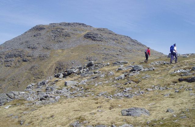
. It is part of a mountain chain that includes three other Munros. When viewed from the north or south it is seen as a distinct pointed hill in contrast to its more bulky neighbour Beinn Dubhchraig, with which it is usually climbed. The mountain is quite rocky and craggy being composed of mica schist
Schist ( ) is a medium-grained metamorphic rock generally derived from fine-grained sedimentary rock, like shale. It shows pronounced ''schistosity'' (named for the rock). This means that the rock is composed of mineral grains easily seen with a l ...
rock."Hamish‘s Mountain Walk" Pages 80 (Gives geology).
Name
The name ''Beinn Os'' has two possible meanings inGaelic
Gaelic (pronounced for Irish Gaelic and for Scots Gaelic) is an adjective that means "pertaining to the Gaels". It may refer to:
Languages
* Gaelic languages or Goidelic languages, a linguistic group that is one of the two branches of the Insul ...
with guide books being divided on the subject. ''Os'' can mean an elk
The elk (: ''elk'' or ''elks''; ''Cervus canadensis'') or wapiti, is the second largest species within the deer family, Cervidae, and one of the largest terrestrial mammals in its native range of North America and Central and East Asia. ...
, or a loch
''Loch'' ( ) is a word meaning "lake" or "inlet, sea inlet" in Scottish Gaelic, Scottish and Irish Gaelic, subsequently borrowed into English. In Irish contexts, it often appears in the anglicized form "lough". A small loch is sometimes calle ...
outlet, with a lochan and a stream with the same name in the immediate vicinity it implies that the area around Ben Oss was where elk were found before they were hunted to extinction."The Magic of the Munros" Pages 15 (Gives details of name translation).
Geography
Ben Oss is especially craggy on its northern face, falling away steeply to the Cononish glen and barring any direct approach from this direction. It has two main ridges which connect to the adjacent Munros ofBen Lui
Ben Lui () is a mountain in the southern Highlands of Scotland. It is a Munro with a height of . Ben Lui is in northeast Argyll and is the highest peak of a mountain chain that includes three other Munros. It has five well-defined ridges radiat ...
and Beinn Dubhchraig and walkers usually arrive at the mountains summit along either of these. One ridge goes north east, east and then south east to form a curving edge around Coire Garbh connecting to Beinn Dubhchraig at the Bealach
A mountain pass is a navigable route through a mountain range or over a ridge. Since mountain ranges can present formidable barriers to travel, passes have played a key role in trade, war, and both human and animal migration throughout history ...
Buidhe with a height of 779 metres. Coire Garbh has Loch Oss lying within its recesses, a body of water measuring roughly 500 by 300 metres. Coire Buidhe stands on the northern side of this eastern ridge, this has a steep headwall and descents north from the bealach to the Cononish glen are not recommended."The Munros" Page 20 (Details steepness of Coire Buidhe).
Ben Oss’s other ridge goes south west to a col
A col is the lowest point on a mountain ridge between two peaks; a mountain pass or saddle.
COL, CoL or col may also refer to:
Computers
* Caldera OpenLinux, a defunct Linux distribution
* , an HTML element specifying a column
* A collision sig ...
at the head of Coire Laoigh with a height of 687 metres which links to Ben Lui. Ben Oss’ southern slopes drop less steeply to Glen Falloch and the land at the head of Loch Lomond
Loch Lomond (; ) is a freshwater Scottish loch which crosses the Highland Boundary Fault (HBF), often considered the boundary between the lowlands of Central Scotland and the Highlands.Tom Weir. ''The Scottish Lochs''. pp. 33-43. Published by ...
. Ben Oss lies on the drainage divide
A drainage divide, water divide, ridgeline, watershed, water parting or height of land is elevated terrain that separates neighboring drainage basins. On rugged land, the divide lies along topographical ridges, and may be in the form of a single ...
of Scotland, all rainfall that falls on the northern slopes drains to the Cononish glen which forms the headwaters of the River Tay
The River Tay (, ; probably from the conjectured Brythonic ''Tausa'', possibly meaning 'silent one' or 'strong one' or, simply, 'flowing' David Ross, ''Scottish Place-names'', p. 209. Birlinn Ltd., Edinburgh, 2001.) is the longest river in Sc ...
and eventually goes to the east coast. Drainage from the southern slopes goes via Glen Falloch and Loch Lomond to reach the sea at the west coast at the Firth of Clyde
The Firth of Clyde, is the estuary of the River Clyde, on the west coast of Scotland. The Firth has some of the deepest coastal waters of the British Isles. The Firth is sheltered from the Atlantic Ocean by the Kintyre, Kintyre Peninsula. The ...
.
Ben Oss alongside Ben Lui
Ben Lui () is a mountain in the southern Highlands of Scotland. It is a Munro with a height of . Ben Lui is in northeast Argyll and is the highest peak of a mountain chain that includes three other Munros. It has five well-defined ridges radiat ...
stand at the head of Glen Fyne, a contuation of the sea loch, Loch Fyne
Loch Fyne (, ; meaning "Loch of the Vine/Wine"), is a sea loch off the Firth of Clyde and forms part of the coast of the Cowal, Cowal Peninsula. Located on the west coast of Argyll and Bute, west of Scotland. It extends inland from the Sound o ...
at long in Argyll and Bute
Argyll and Bute (; , ) is one of 32 unitary authority, unitary council areas of Scotland, council areas in Scotland and a lieutenancy areas of Scotland, lieutenancy area. The current lord-lieutenant for Argyll and Bute is Jane Margaret MacLeod ...
.
Climbing
Because of a lack of good access paths from the south (Glen Falloch), Ben Oss is usually climbed from the area just south of Tyndrum, with the usual start being at Dalrigh (grid reference ) on theA82 road
The A82 is a major road in Scotland that runs from Glasgow to Inverness via Fort William, Highland, Fort William. It is one of the principal north-south routes in Scotland and is mostly a trunk road managed by Transport Scotland, who view it a ...
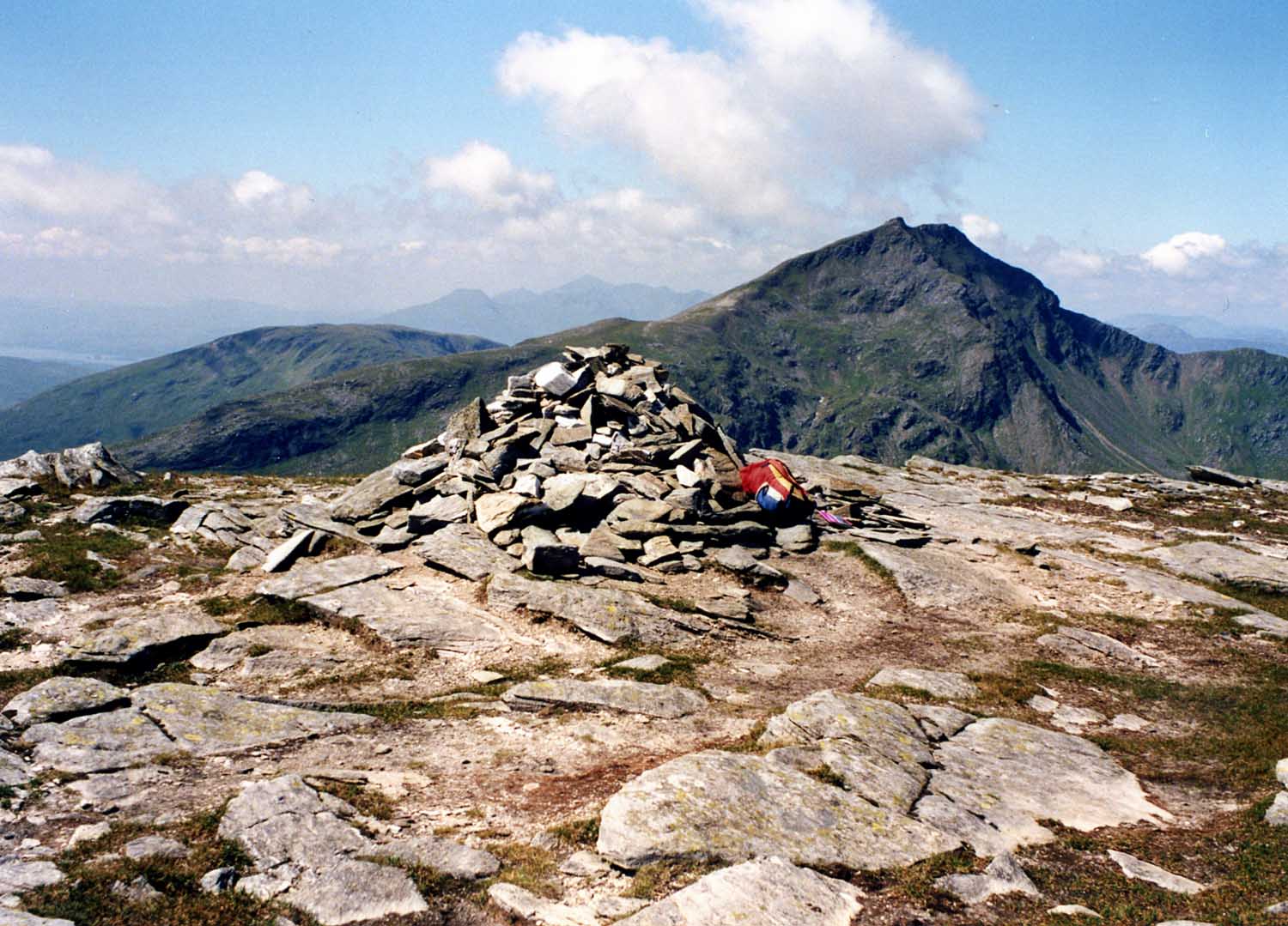
. Many guide books recommend climbing Ben Oss with Beinn Dubhchraig from Dalrigh and this allows for a less steep approach over Dubhchraig and then continuing to Ben Oss via the Bealach Buidhe. A circular walk around the head of the Cononish glen can be continued over Ben Lui and Beinn Chuirn to finish again at Dalrigh."The Munros" Page 20 (Gives details of ascents). The summit of the mountain is flattish and the medium size cairn stands on an area of large slabby rocks interspersed with grass. The summit has a prominence
In topography, prominence or relative height (also referred to as autonomous height, and shoulder drop in US English, and drop in British English) measures the height of a mountain or hill's summit relative to the lowest contour line encircling ...
of 342 metres and gives a fine vista of the southern highlands, it is a good place to admire the craggy eastern face of neighbouring Ben Lui.
References
*''The Munros'', Scottish Mountaineering Trust, 1986, Donald Bennett (Editor) *''The High Mountains of Britain and Ireland'', Diadem, 1993,Irvine Butterfield
Irvine Butterfield (1936–2009) was an environmentalist, hillwalker and author of several books about mountains and the outdoor environment who took a significant role in the running of organisations with such interests in Scotland. He was a go ...
,
*''The Munros, Scotland's Highest Mountains'', Cameron McNeish
Cameron McNeish FRSGS is a Scottish wilderness hiker, backpacker and mountaineer who is an authority on outdoor pursuits. In this field he is best known as an author and broadcaster although he is also a magazine editor, lecturer and after dinn ...
,
*''The Magic Of The Munros'', Irvine Butterfield,
*''Hamish’s Mountain Walk'', Baton Wicks, 1996, Hamish Brown
Hamish Brown Order of the British Empire, M.B.E. Royal Scottish Geographical Society, FRSGS is a professional writer, lecturer and photographer specialising in mountain and outdoor topics. He is best known for his walking exploits in the Scottish ...
,
*''The Munros Almanac'', Neil Wilson Publishing, 1991, Cameron McNeish,
Footnotes
{{coord, 56.3904, N, 4.7743, W, scale:5000_region:GB, display=title
Munros
Marilyns of Scotland
Mountains and hills of the Southern Highlands
Mountains and hills of Stirling (council area)
One-thousanders of Scotland