|
Space Geodetic
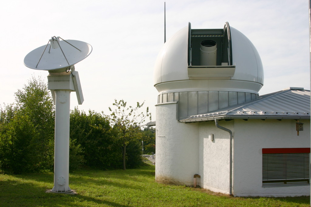
Space geodesy is geodesy by means of sources external to Earth, mainly artificial satellites (in satellite geodesy) but also quasars (in very-long-baseline interferometry, VLBI), visible stars (in stellar triangulation Stellar triangulation is a method of geodesy and of its subdiscipline space geodesy used to measure Earth's geometric shape. Stars were first used for this purpose by the Finnish astronomer Yrjö Väisälä in 1959, who made astrometric photograp ...), and the retroreflectors on the Moon (in lunar laser ranging, LLR). See also * Astronomical geodesy Geodesy Geodesy {{Space-stub ... [...More Info...] [...Related Items...] OR: [Wikipedia] [Google] [Baidu] |
Geodesy
Geodesy ( ) is the Earth science of accurately measuring and understanding Earth's figure (geometric shape and size), orientation in space, and gravity. The field also incorporates studies of how these properties change over time and equivalent measurements for other planets (known as ''planetary geodesy''). Geodynamical phenomena, including crustal motion, tides and polar motion, can be studied by designing global and national control networks, applying space geodesy and terrestrial geodetic techniques and relying on datums and coordinate systems. The job title is geodesist or geodetic surveyor. History Definition The word geodesy comes from the Ancient Greek word ''geodaisia'' (literally, "division of Earth"). It is primarily concerned with positioning within the temporally varying gravitational field. Geodesy in the German-speaking world is divided into "higher geodesy" ( or ), which is concerned with measuring Earth on the global scale, and "practical geodes ... [...More Info...] [...Related Items...] OR: [Wikipedia] [Google] [Baidu] |
Artificial Satellites
A satellite or artificial satellite is an object intentionally placed into orbit in outer space. Except for passive satellites, most satellites have an electricity generation system for equipment on board, such as solar panels or radioisotope thermoelectric generators (RTGs). Most satellites also have a method of communication to ground stations, called transponders. Many satellites use a standardized bus to save cost and work, the most popular of which is small CubeSats. Similar satellites can work together as a group, forming constellations. Because of the high launch cost to space, satellites are designed to be as lightweight and robust as possible. Most communication satellites are radio relay stations in orbit and carry dozens of transponders, each with a bandwidth of tens of megahertz. Satellites are placed from the surface to orbit by launch vehicles, high enough to avoid orbital decay by the atmosphere. Satellites can then change or maintain the orbit by propulsion, ... [...More Info...] [...Related Items...] OR: [Wikipedia] [Google] [Baidu] |
Satellite Geodesy
Satellite geodesy is geodesy by means of artificial satellites—the measurement of the form and dimensions of Earth, the location of objects on its surface and the figure of the Earth's gravity field by means of artificial satellite techniques. It belongs to the broader field of space geodesy. Traditional astronomical geodesy is ''not'' commonly considered a part of satellite geodesy, although there is considerable overlap between the techniques. The main goals of satellite geodesy are: # Determination of the figure of the Earth, positioning, and navigation (geometric satellite geodesy) # Determination of geoid, Earth's gravity field and its temporal variations (dynamical satellite geodesy or satellite physical geodesy) # Measurement of geodynamical phenomena, such as crustal dynamics and polar motion Satellite geodetic data and methods can be applied to diverse fields such as navigation, hydrography, oceanography and geophysics. Satellite geodesy relies heavily on o ... [...More Info...] [...Related Items...] OR: [Wikipedia] [Google] [Baidu] |
Quasars
A quasar is an extremely luminous active galactic nucleus (AGN). It is pronounced , and sometimes known as a quasi-stellar object, abbreviated QSO. This emission from a galaxy nucleus is powered by a supermassive black hole with a mass ranging from millions to tens of billions of solar masses, surrounded by a gaseous accretion disc. Gas in the disc falling towards the black hole heats up because of friction and releases energy in the form of electromagnetic radiation. The radiant energy of quasars is enormous; the most powerful quasars have luminosities thousands of times greater than that of a galaxy such as the Milky Way. Usually, quasars are categorized as a subclass of the more general category of AGN. The redshifts of quasars are of cosmological origin. The term originated as a contraction of "quasi-stellar '' tar-like' radio source"—because quasars were first identified during the 1950s as sources of radio-wave emission of unknown physical origin—and when identif ... [...More Info...] [...Related Items...] OR: [Wikipedia] [Google] [Baidu] |
Very-long-baseline Interferometry
Very-long-baseline interferometry (VLBI) is a type of astronomical interferometer, astronomical interferometry used in radio astronomy. In VLBI a signal from an astronomical radio source, such as a quasar, is collected at multiple radio telescopes on Earth or in space. The distance between the radio telescopes is then calculated using the time difference between the arrivals of the radio signal at different telescopes. This allows observations of an object that are made simultaneously by many radio telescopes to be combined, emulating a telescope with a size equal to the maximum separation between the telescopes. Data received at each antenna in the array include arrival times from a local atomic clock, such as a hydrogen maser. At a later time, the data are correlated with data from other antennas that recorded the same radio signal, to produce the resulting image. The resolution achievable using interferometry is proportional to the observing frequency. The VLBI technique e ... [...More Info...] [...Related Items...] OR: [Wikipedia] [Google] [Baidu] |
Visible Stars
This is a list of stars arranged by their apparent magnitude – their brightness as observed from Earth. It includes all stars brighter than magnitude +2.50 in visible light, measured using a ''V''-band filter in the UBV photometric system. Stars in binary systems (or other multiples) are listed by their ''total'' or ''combined'' brightness if they appear as a single star to the naked eye, or listed separately if they do not. As with all magnitude systems in astronomy, the scale is logarithmic and inverted i.e. lower/more negative numbers are brighter. Most stars on this list appear bright from Earth because they are nearby, not because they are intrinsically luminous. For a list which compensates for the distances, converting the ''apparent'' magnitude to the ''absolute'' magnitude, see the list of most luminous stars. Measurement The Sun is the brightest star as viewed from Earth, at −26.74 mag. The second brightest is Sirius at −1.46 mag. For compa ... [...More Info...] [...Related Items...] OR: [Wikipedia] [Google] [Baidu] |
Stellar Triangulation
Stellar triangulation is a method of geodesy and of its subdiscipline space geodesy used to measure Earth's geometric shape. Stars were first used for this purpose by the Finnish astronomer Yrjö Väisälä in 1959, who made astrometric photographs of the night sky at two stations together with a lighted balloon probe between them. Even this first step showed the potential of the method, as Väisälä got the azimuth between Helsinki and Turku (a distance of 150 km) with an accuracy of 1″. Soon the method was successfully tested by ballistic rockets and for some special satellites. Adequate computer programs were written for * the astrometric reduction of the photographic plates, * the intersection of the "observation planes" containing the stations and the targets, * and the least-squares adjustment of stellar-terrestrial networks with redundancy. The advantages of stellar triangulation were the possibility to cross far distances (terrestrial observations are restrict ... [...More Info...] [...Related Items...] OR: [Wikipedia] [Google] [Baidu] |
Retroreflectors On The Moon
Retroreflectors are devices which reflect light back to its source. Five were left at five sites on the Moon by three crews of the Apollo program and two remote landers of the Lunokhod program. Lunar reflectors have enabled precise measurement of the Earth–Moon distance since 1969 using lunar laser ranging.Slava G. Turyshev: From Quantum to Cosmos: Fundamental Physics Research in Space' (2009) - Page 300 Successfully placed reflectors Attempted and planned reflectors Gallery Image:Apollo 11 Lunar Laser Ranging Experiment.jpg, Apollo 11 Lunar Laser Ranging Retroreflector Image:ALSEP AS14-67-9386.jpg, Apollo 14 retroreflector Image:ALSEP_AS15-85-11468.jpg, Close-up of Apollo 15 retroreflector Image:Lunokhod-2 model.jpg, Model of Lunokhod 2 retroreflector (hexagon in front) See also * Lunar laser ranging * List of artificial objects on the Moon * List of missions to the Moon As part of human exploration of the Moon, numerous space missions have been unde ... [...More Info...] [...Related Items...] OR: [Wikipedia] [Google] [Baidu] |
Astronomical Geodesy
Geodetic astronomy or astronomical geodesy (astro-geodesy) is the application of astronomical methods into geodetic networks and other technical projects of geodesy. Applications The most important applications are: * Establishment of geodetic datum systems (e.g. ED50) or at expeditions * apparent places of stars, and their proper motions * precise astronomical navigation * astro-geodetic geoid determination * modelling the rock densities of the topography and of geological layers in the subsurface * Monitoring of the Earth rotation and polar wandering * Contribution to the time system of physics and geosciences Measuring techniques Important measuring techniques are: * Latitude determination and longitude determination, by theodolites, tacheometers, astrolabes or zenith cameras * time and star positions by observation of star transits, e.g. by meridian circles (visual, photographic or CCD) * Azimuth determination ** for the exact orientation of geodetic networks ** for ... [...More Info...] [...Related Items...] OR: [Wikipedia] [Google] [Baidu] |
Geodesy
Geodesy ( ) is the Earth science of accurately measuring and understanding Earth's figure (geometric shape and size), orientation in space, and gravity. The field also incorporates studies of how these properties change over time and equivalent measurements for other planets (known as ''planetary geodesy''). Geodynamical phenomena, including crustal motion, tides and polar motion, can be studied by designing global and national control networks, applying space geodesy and terrestrial geodetic techniques and relying on datums and coordinate systems. The job title is geodesist or geodetic surveyor. History Definition The word geodesy comes from the Ancient Greek word ''geodaisia'' (literally, "division of Earth"). It is primarily concerned with positioning within the temporally varying gravitational field. Geodesy in the German-speaking world is divided into "higher geodesy" ( or ), which is concerned with measuring Earth on the global scale, and "practical geodes ... [...More Info...] [...Related Items...] OR: [Wikipedia] [Google] [Baidu] |


