|
Geopark
A geopark is a protected area with internationally significant geology within which Sustainability, sustainable development is sought and which includes tourism, conservation, education and research concerning not just geology but other relevant sciences. In 2005, a European Geopark was defined as being: "a territory with a particular geological heritage and with a sustainable territorial development....the ultimate aim of a European Geopark is to bring enhanced employment opportunities for the people who live there." Today the geopark is virtually synonymous with the UNESCO geopark, which is defined and managed under the voluntary authority of UNESCO's International Geoscience Programme, International Geoscience and Geoparks Programme (IGGP). UNESCO provides a standard for geoparks and a certification service to territories that apply for it. The service is available to member states of UNESCO. The list of members is not the same as the member states of the United Nations. Memb ... [...More Info...] [...Related Items...] OR: [Wikipedia] [Google] [Baidu] |
Global Geoparks Network
UNESCO Global Geoparks (UGGp) are geoparks certified by the UNESCO Global Geoparks Council as meeting all the requirements for belonging to the Global Geoparks Network (GGN). The GGN is both a network of geoparks and the agency of the United Nations Educational, Scientific and Cultural Organization (UNESCO) that administers the network. The agency was founded in 2004 in partnership with the International Union of Geological Sciences (IUGS). The network was set up to conserve Earth's geological heritage, as well as to promote the sustainable research and development by the concerned communities. To implement these goals they adopted the concept of geopark, a term that had already been in use for one of the proposed parks. Geoparks were conceived as "single, unified geographical areas where sites and landscapes of international geological significance are managed with a holistic concept of protection, education and sustainable development." As the geopark did not naturally conform ... [...More Info...] [...Related Items...] OR: [Wikipedia] [Google] [Baidu] |
European Geoparks Network
The European Geoparks Network (EGN) functions as the regional organization of the Global Geoparks Network (GGN) and the UNESCO International Geosciences and Geoparks Programme (UNESCO-IGGP). Its main objective is to ensure cooperation between geoparks for the protection of Geoheritage, geological heritage and the promotion of sustainable development of their territories in Europe. In 2020 January, the EGN had 75 institutional members (UNESCO Global Geoparks) from 26 European countries and there are several aspiring geopark projects, applying for a UNESCO label and therefore the permanent EGN membership. History The 1990s are widely considered as the birth of geoheritage as a dedicated domain of the geosciences, dealing with the preservation and valorisation of the Earth's abiotical heritage, its geodiversity. The idea of coordinated work on geology-focused territorial frameworks in Europe was discussed during the International Geological Congress in Beijing, 1997. After preparato ... [...More Info...] [...Related Items...] OR: [Wikipedia] [Google] [Baidu] |
Geotourism
Geotourism is tourism associated with geological attractions and destinations. Geotourism (tourism with a geological base) deals with the abiotic natural and built environments.Sadry, B.N.(2009)''Fundamentals of Geotourism: with special emphasis on Iran'', SAMT Organization publishers,Tehran.220p.(English Summary available Online at: https://journals.openedition.org/physio-geo/4873?lang=en Geotourism was first defined in England by Thomas Alfred Hose in 1995.Hose, T. A. (2012), "3G's for Modern Geotourism", '' Geoheritage Journal'', 4: 7-24 Definitions of modern geotourism Most of the world defines geotourism as purely the study of geological and geomorphological features. The key definitions of modern geotourism (abiotic nature-based tourism) include: # "...part of the tourist's activity in which they have the geological patrimony as their main attraction. Their objective is to search for protected patrimony through the conservation of their resources and of the tourist's En ... [...More Info...] [...Related Items...] OR: [Wikipedia] [Google] [Baidu] |
Geoconservation
Geoconservation is the practice of recognising, protecting and managing sites and landscapes which have value for their geology or geomorphology. The conservation of these geological sites is through government agencies and local geological societies in areas such as Europe and Africa. The designation of these sites is done through an analysis of the site, and the production of proper management infrastructure. The principles of geoconservation are to create a means of protection for the sites, and assess their value to the geological community. Typically the conservation of geodiversity at a site or within a landscape takes place alongside that of biodiversity. In European countries The state of geoconservation legislation in 37 countries in Europe was described by specialists in each country and published in ''Geoheritage in Europe and its conservation'' in 2012 by ProGEO (The European Association for the Conservation of the Geological Heritage, now, in 2023, the International Ass ... [...More Info...] [...Related Items...] OR: [Wikipedia] [Google] [Baidu] |
International Geoscience Programme
The International Geoscience and Geoparks Programme (IGCP) is a cooperative enterprise of UNESCO (the United Nations Educational, Scientific and Cultural Organization) and the International Union of Geological Sciences The International Union of Geological Sciences (IUGS) is an international non-governmental organization devoted to global cooperation in the field of geology. As of 2023, it represents more than 1 million geoscientists around the world. About Fo ... (IUGS). It was launched in 1972 and originally termed the ''International Geological Correlation Programme'', the source of the acronym IGCP which it retains. For decades the programme was known as the ''International Geoscience Programme''. In November 2015 the name was changed to ''International Geoscience and Geoparks Programme'' as the global geoparks were made part of the programme. The aim of the IGCP is to facilitate research cooperation among geoscientists across frontiers and national boundaries, through jo ... [...More Info...] [...Related Items...] OR: [Wikipedia] [Google] [Baidu] |
Geoheritage
Geoheritage (a blend of ''geological'' and ''heritage'') is the geological aspect of natural and cultural heritage. A geosite is a particular geological heritage asset. It is a heritage category comparable to other forms of natural heritage, such as biodiversity. History of the concept The first reference to geoheritage as such was at a 1993 conference held in the UK, the Malvern International Conference on Geological and Landscape Conservation. The term geological heritage was first mentioned at the First International Symposium on the Conservation of our Geological Heritage at Digne, France in 1991. The matter is further discussed in 2002 by Sharples. Conceptually, geoheritage derives from various writings of Busby et al. 2001 and Hallam 1989). In Sharples 1995 the original concept of geoheritage further developed to include the protection of dynamic geological processes and geodiversity. In Sadry 2021 the concept of geoheritage have more developed to include the vertical d ... [...More Info...] [...Related Items...] OR: [Wikipedia] [Google] [Baidu] |
Harz
The Harz (), also called the Harz Mountains, is a highland area in northern Germany. It has the highest elevations for that region, and its rugged terrain extends across parts of Lower Saxony, Saxony-Anhalt, and Thuringia. The name ''Harz'' derives from the Middle High German word ''Hardt'' or ''Hart'' (hill forest). The name ''Hercynia'' derives from a Celtic name and could refer to other mountain forests, but has also been applied to the geology of the Harz. The Brocken is the highest summit in the Harz with an elevation of above sea level. The Wurmberg () is the highest peak located entirely within the state of Lower Saxony. Geography Location and extent The Harz has a length of , stretching from the town of Seesen in the northwest to Eisleben in the east, and a width of . It occupies an area of , and is divided into the Upper Harz (''Oberharz'') in the northwest, which is up to 800 m high, apart from the 1,100 m high Brocken massif, and the Lower Harz (''Unterhar ... [...More Info...] [...Related Items...] OR: [Wikipedia] [Google] [Baidu] |
Rudolph Augustus, Duke Of Braunschweig-Wolfenbüttel
Rudolph Augustus (16 May 1627 – 26 January 1704), a member of the House of Welf, was Duke of Brunswick-Lüneburg and ruled as Prince of Brunswick-Wolfenbüttel from 1666 until his death. In 1685 he made his younger brother Anthony Ulrich co-ruler. Life He was born in Hitzacker, then the residence of his father Duke Augustus the Younger of Brunswick-Lüneburg and his second wife Princess Dorothea of Anhalt-Zerbst. His father assumed the rule in the Principality of Brunswick-Wolfenbüttel, after his Welf cousin Duke Frederick Ulrich had died childless in 1634. Rudolph Augustus succeeded his father as ruling Prince of Brunswick-Wolfenbüttel in 1666. More interested in his studies and hunting, he soon after appointed his politically astute younger brother Anthony Ulrich governor. In 1671 both besieged and finally occupied the city of Braunschweig, ending about 250 years of local autonomy. During his reign, Rudolph Augustus concentrated on the Baroque expansion of his ... [...More Info...] [...Related Items...] OR: [Wikipedia] [Google] [Baidu] |
Fossil Tree Stumps At Fossil Grove Glasgow 1977
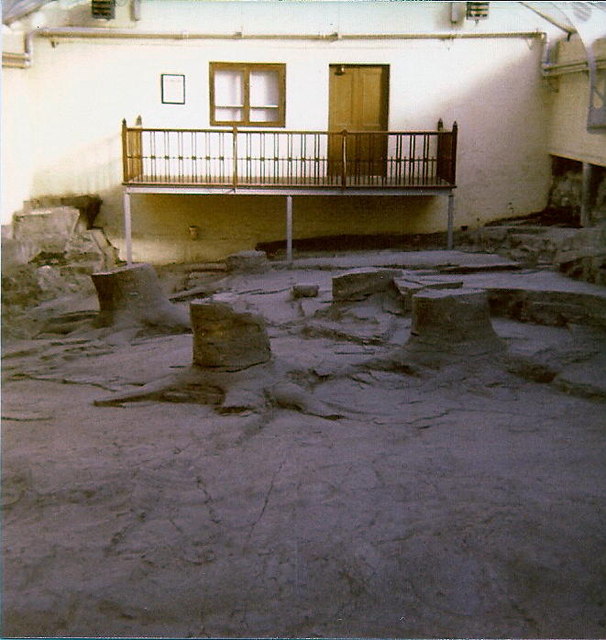
A fossil (from Classical Latin , ) is any preserved remains, impression, or trace of any once-living thing from a past geological age. Examples include bones, shells, exoskeletons, stone imprints of animals or microbes, objects preserved in amber, hair, petrified wood and DNA remnants. The totality of fossils is known as the ''fossil record''. Though the fossil record is incomplete, numerous studies have demonstrated that there is enough information available to give a good understanding of the pattern of diversification of life on Earth. In addition, the record can predict and fill gaps such as the discovery of ''Tiktaalik'' in the arctic of Canada. Paleontology includes the study of fossils: their age, method of formation, and evolutionary significance. Specimens are sometimes considered to be fossils if they are over 10,000 years old. The oldest fossils are around 3.48 billion years to 4.1 billion years old. Early edition, published online before print. The ob ... [...More Info...] [...Related Items...] OR: [Wikipedia] [Google] [Baidu] |
National Park
A national park is a nature park designated for conservation (ethic), conservation purposes because of unparalleled national natural, historic, or cultural significance. It is an area of natural, semi-natural, or developed land that is protected and owned by a government. Although governments hold different standards for national park designation, the conservation of 'wild nature' for posterity and as a symbol of national pride is a common motivation for the continued protection of all national parks around the world. National parks are almost always accessible to the public.Gissibl, B., S. Höhler and P. Kupper, 2012, ''Civilizing Nature, National Parks in Global Historical Perspective'', Berghahn, Oxford Usually national parks are developed, owned and managed by national governments, though in some countries with federal government, federal or Devolution, devolved forms of government, "national parks" may be the responsibility of subnational, regional, or local authorities. Th ... [...More Info...] [...Related Items...] OR: [Wikipedia] [Google] [Baidu] |
Rhineland-Palatinate
Rhineland-Palatinate ( , ; ; ; ) is a western state of Germany. It covers and has about 4.05 million residents. It is the ninth largest and sixth most populous of the sixteen states. Mainz is the capital and largest city. Other cities are Ludwigshafen am Rhein, Koblenz, Trier, Kaiserslautern, Worms, and Neuwied. It is bordered by North Rhine-Westphalia, Saarland, Baden-Württemberg and Hesse and by France, Luxembourg and Belgium. Rhineland-Palatinate was established in 1946 after World War II, from parts of the former states of Prussia (part of its Rhineland and Nassau provinces), Hesse ( Rhenish Hesse) and Bavaria (its former outlying Palatinate kreis or district), by the French military administration in Allied-occupied Germany. Rhineland-Palatinate became part of the Federal Republic of Germany in 1949 and shared the country's only border with the Saar Protectorate until the latter was returned to German control in 1957. Rhineland-Palatinate's natural and c ... [...More Info...] [...Related Items...] OR: [Wikipedia] [Google] [Baidu] |


