|
Tyndall Stone
Tyndall Stone is a registered trademark name by Gillis Quarries Ltd. Tyndall Stone is a dolomitic limestone that is quarried from the Selkirk Member of the Ordovician Red River Formation in the vicinity of Garson and Tyndall, Manitoba, Canada. It is a cream-coloured limestone with a pervasive mottling of darker dolomite. The mottling gives the rock a tapestry-like effect, and it is popular for use as a building and ornamental stone.Glass, D.J. (editor) 1997. Lexicon of Canadian Stratigraphy, vol. 4, Western Canada including eastern British Columbia, Alberta, Saskatchewan and southern Manitoba. Canadian Society of Petroleum Geologists, Calgary, 1423 p. on CD-ROM. . Tyndall Stone is highly fossiliferous and the fossils contribute to its aesthetic appeal. It contains numerous fossil gastropods, brachiopods, cephalopods, trilobites, corals, stromatoporoids, '' Receptaculites'', and others. The mottling results from burrowing by marine creatures that occurred during and sho ... [...More Info...] [...Related Items...] OR: [Wikipedia] [Google] [Baidu] |
Stromatoporoid
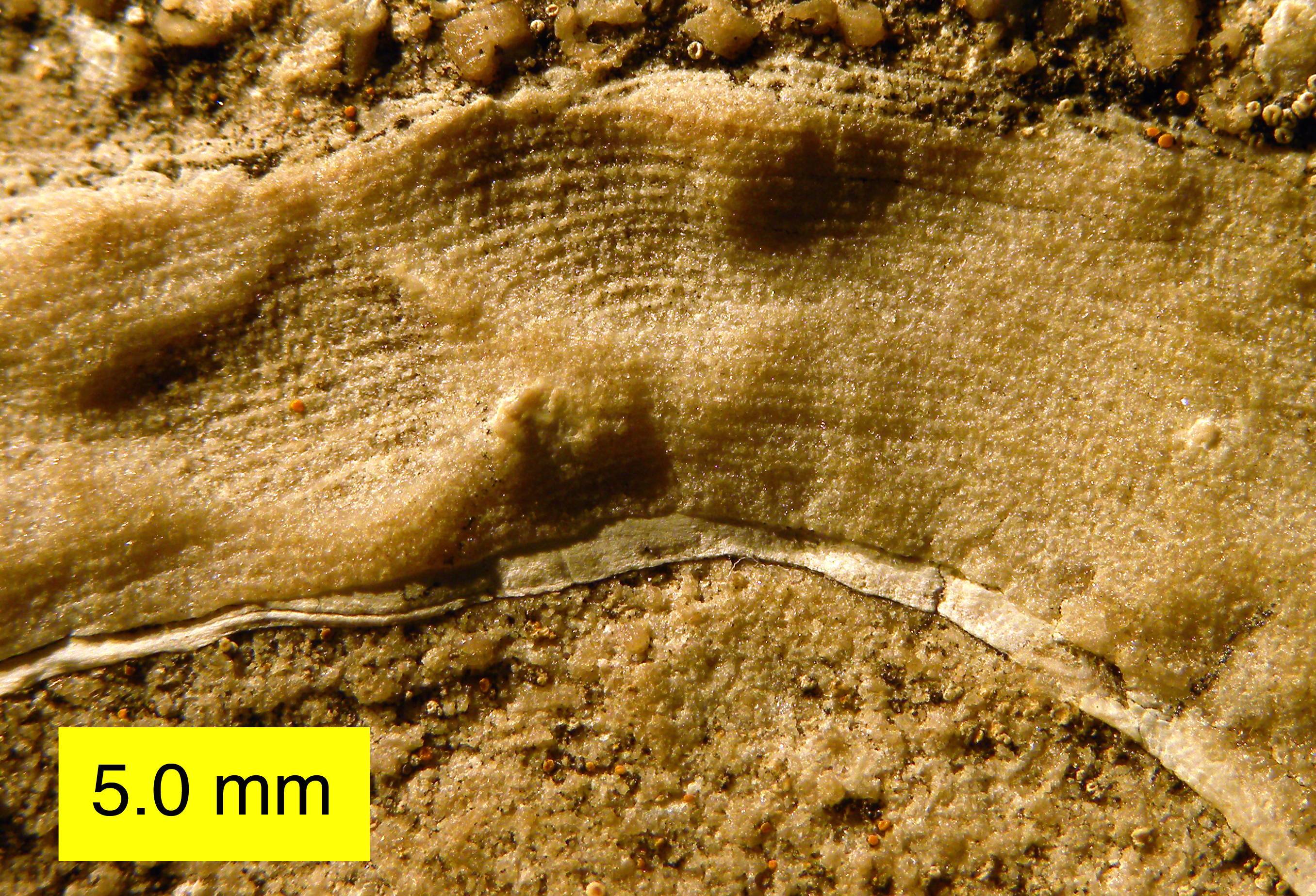
Stromatoporoidea is an extinct clade of sea sponges common in the fossil record from the Middle Ordovician to the Late Devonian.Stock, C.W. 2001, Stromatoporoidea, 1926–2000: ''Journal of Paleontology'', v. 75, p. 1079–1089. They can be characterized by their densely layered calcite skeletons lacking spicules. Stromatoporoids were among the most abundant and important reef-builders of their time, living close together in flat biostromes or elevated bioherms on soft tropical carbonate platforms. Externally, some species have raised bumps (mamelons) and star-shaped crevices (astrorhizae), which together help vent exhalant water away from the living surface. Internally, stromatoporoids have a mesh-like skeletal system combining extensive horizontal layers (laminae), vertical rods (pillars), and boxy spaces (galleries), along with other features. The most common growth forms range from laminar (flattened) to domical (dome-shaped). Spheroidal, finger-like, or tree-like species ... [...More Info...] [...Related Items...] OR: [Wikipedia] [Google] [Baidu] |
Queen Elizabeth II Building
The Queen Elizabeth II Building, previously known as the Federal Public Building, is an eleven-storey Art Deco building in downtown Edmonton, Alberta. Built with granite and Tyndall stone, the building is located in the northeast corner of the Alberta Legislature grounds, overlooking the Violet King Henry Plaza. It hosts provincial government employees and Members of the Legislative Assembly (MLA), and is considered one of Edmonton's most significant modern buildings. Designed in 1939 by a local architect, the building's construction was delayed by the outbreak of World War II, and took place from 1955 to 1958. It was originally owned by the Government of Canada and hosted its offices for Western Canada until 1988, when the government relocated its staff to Canada Place. The Government of Alberta acquired the property in 1983, anticipating the relocation; it sat vacant following the relocation. Major renovations were undertaken starting from 2009, with offices opening for use in e ... [...More Info...] [...Related Items...] OR: [Wikipedia] [Google] [Baidu] |
Saskatoon, Saskatchewan
Saskatoon () is the largest city in the Provinces and territories of Canada, Canadian province of Saskatchewan. It straddles a bend in the South Saskatchewan River in the central region of the province. It is located along the Trans-Canada Highway, Trans-Canada Yellowhead Highway, and has served as the cultural and economic hub of central Saskatchewan since its founding in 1882 as a Temperance movement, Temperance colony. With a Canada 2021 Census, 2021 census population of 266,141, Saskatoon is the List of cities in Saskatchewan, largest city in the province, and the List of census metropolitan areas and agglomerations in Canada, 17th largest Census Metropolitan Area in Canada, with a 2021 census population of 317,480. Saskatoon is home to the University of Saskatchewan, the Meewasin Valley Authority—which protects the South Saskatchewan River and provides for the city's popular riverbank park spaces—and Wanuskewin Heritage Park, a National Historic Site of Canada and UNE ... [...More Info...] [...Related Items...] OR: [Wikipedia] [Google] [Baidu] |
University Of Saskatchewan
The University of Saskatchewan (U of S, or USask) is a Universities in Canada, Canadian public university, public research university, founded on March 19, 1907, and located on the east side of the South Saskatchewan River in Saskatoon, Saskatchewan, Canada. An "Act to establish and incorporate a University for the Province of Saskatchewan" was passed by the provincial legislature in 1907. It established the provincial university on March 19, 1907 "for the purpose of providing facilities for higher education in all its branches and enabling all persons without regard to race, creed or religion to take the fullest advantage". The University of Saskatchewan is the largest education institution in the Canadian province of Saskatchewan. The University of Saskatchewan is one of Canada's top research universities (based on the number of Canada Research Chairs) and is a member of the U15 Group of Canadian Research Universities (the 15 most research-intensive universities in Canada). The ... [...More Info...] [...Related Items...] OR: [Wikipedia] [Google] [Baidu] |
Regina, Saskatchewan
Regina ( ) is the capital city of the Provinces and territories of Canada, Canadian province of Saskatchewan. The city is the second-largest in the province, and is a commercial centre for southern Saskatchewan. As of the 2021 Canadian census, 2021 census, Regina had a List of cities in Saskatchewan, city population of 226,404, and a List of census metropolitan areas and agglomerations in Canada, metropolitan area population of 249,217. It is governed by Regina City Council. The city is surrounded by the Rural Municipality of Sherwood No. 159. Regina was History of Northwest Territories capital cities, previously the seat of government of the Northwest Territories, North-West Territories, of which the current provinces of Saskatchewan and Alberta originally formed part, and of the District of Assiniboia. The site was previously called Wascana (from "Buffalo Bones"), but was renamed to ''Regina'' (Latin for "Queen") in 1882 in honour of Queen Victoria. The name was proposed by Q ... [...More Info...] [...Related Items...] OR: [Wikipedia] [Google] [Baidu] |
Saskatchewan Legislative Building
The Saskatchewan Legislative Building is located in Regina, Saskatchewan, Regina, Saskatchewan, Canada, and houses the Legislative Assembly of Saskatchewan. History The Saskatchewan Legislative Building was built between 1908 and 1912 in the Beaux-Arts architecture, Beaux-Arts style to a design by Edward Maxwell, Edward and William Sutherland Maxwell of Montreal. The Maxwells also supervised construction of the building by the Montreal company P. Lyall & Sons, who later built the Centre Block of the federal Parliament Building in Ottawa after the 1866 Parliament Building was destroyed by fire in 1916. Piles began to be drilled for the foundations during the autumn of 1908 and in 1909 the Governor General of Canada, Albert Grey, 4th Earl Grey, the Earl Grey, laid the cornerstone. In 1912, Prince Arthur, Duke of Connaught and Strathearn, Prince Arthur, Duke of Connaught, by then the serving governor general, inaugurated the building. The design contemplates expansion of the buil ... [...More Info...] [...Related Items...] OR: [Wikipedia] [Google] [Baidu] |
Ottawa, Ontario
Ottawa is the capital city of Canada. It is located in the southern Ontario, southern portion of the province of Ontario, at the confluence of the Ottawa River and the Rideau River. Ottawa borders Gatineau, Gatineau, Quebec, and forms the core of the Ottawa–Gatineau census metropolitan area (CMA) and the National Capital Region (Canada), National Capital Region (NCR). Ottawa had a city population of 1,017,449 and a metropolitan population of 1,488,307, making it the list of the largest municipalities in Canada by population, fourth-largest city and list of census metropolitan areas and agglomerations in Canada, fourth-largest metropolitan area in Canada. Ottawa is the political centre of Canada and the headquarters of the federal government. The city houses numerous List of diplomatic missions in Ottawa, foreign embassies, key buildings, organizations, and institutions of Government of Canada, Canada's government; these include the Parliament of Canada, the Supreme Court of ... [...More Info...] [...Related Items...] OR: [Wikipedia] [Google] [Baidu] |
Parliament Hill
Parliament Hill (), colloquially known as The Hill, is an area of Crown land on the southern bank of the Ottawa River that houses the Parliament of Canada in downtown Ottawa, Ontario. It accommodates a suite of Gothic revival buildings whose architectural elements were chosen to evoke the history of parliamentary democracy. Parliament Hill attracts approximately three million visitors each year. The Parliamentary Protective Service is responsible for law enforcement on Parliament Hill and in the parliamentary precinct, while the National Capital Commission is responsible for maintaining the area of the grounds. Development of the area, which in the 18th and early 19th centuries was the site of a military base, into a governmental precinct began in 1859 after Queen Victoria chose Ottawa as the Capital city, capital of the Province of Canada. Following several extensions to the Parliament and departmental buildings, and a fire in 1916 that destroyed the Centre Block, Parliament ... [...More Info...] [...Related Items...] OR: [Wikipedia] [Google] [Baidu] |
United States
The United States of America (USA), also known as the United States (U.S.) or America, is a country primarily located in North America. It is a federal republic of 50 U.S. state, states and a federal capital district, Washington, D.C. The 48 contiguous states border Canada to the north and Mexico to the south, with the semi-exclave of Alaska in the northwest and the archipelago of Hawaii in the Pacific Ocean. The United States asserts sovereignty over five Territories of the United States, major island territories and United States Minor Outlying Islands, various uninhabited islands in Oceania and the Caribbean. It is a megadiverse country, with the world's List of countries and dependencies by area, third-largest land area and List of countries and dependencies by population, third-largest population, exceeding 340 million. Its three Metropolitan statistical areas by population, largest metropolitan areas are New York metropolitan area, New York, Greater Los Angeles, Los Angel ... [...More Info...] [...Related Items...] OR: [Wikipedia] [Google] [Baidu] |
Canada
Canada is a country in North America. Its Provinces and territories of Canada, ten provinces and three territories extend from the Atlantic Ocean to the Pacific Ocean and northward into the Arctic Ocean, making it the world's List of countries and dependencies by area, second-largest country by total area, with the List of countries by length of coastline, world's longest coastline. Its Canada–United States border, border with the United States is the world's longest international land border. The country is characterized by a wide range of both Temperature in Canada, meteorologic and Geography of Canada, geological regions. With Population of Canada, a population of over 41million people, it has widely varying population densities, with the majority residing in List of the largest population centres in Canada, urban areas and large areas of the country being sparsely populated. Canada's capital is Ottawa and List of census metropolitan areas and agglomerations in Canada, ... [...More Info...] [...Related Items...] OR: [Wikipedia] [Google] [Baidu] |
Lower Fort Garry
Lower Fort Garry was built in 1830 by the Hudson's Bay Company on the western bank of the Red River, north of the original Fort Garry (now in Winnipeg, Manitoba, Canada). Treaty 1 was signed there. A devastating flood destroyed Fort Garry in 1826, prompting the Company's then-governor, George Simpson, to search for a safer location down river. Governor Simpson chose the site of Lower Fort Garry because of its high ground and location below the St. Andrew's Rapids, eliminating a time-consuming portage of heavy fur packs and York boats. However, the fort never became the administrative centre it was intended, since most of the population of the area was centred near The Forks and objected to the extra travel required to do business at the new fort. As a result, Upper Fort Garry was rebuilt in stone at The Forks, very near the original Fort Garry site. History Early 19th century (1830–1850) The first buildings built at the fort in 1830 were the "fur loft", which housed ... [...More Info...] [...Related Items...] OR: [Wikipedia] [Google] [Baidu] |


