|
Spits Of Azov Sea
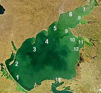
__NOTOC__ The Spits of the Sea of Azov are narrow strips of land in the Sea of Azov which can be as long as 112 km (Arabat Spit, the world's longest spit), 45 km (Fedotov Spit), 31 km (Achuevsk Spit), 30 km (Obitochna Spit) and 23 km (Berdyansk Spit). Their total length exceeds 300 km which is larger than the width of the sea (about 180 km). Most of the spits were formed as a result of deposition of sand, silt and shells by the river flows into the Azov Sea bays. Therefore, many spits stretch to the south into the sea and are continuations of the (right) river banks (see table and map). The Chushka and Tuzla spits are located inside the Strait of Kerch; the former spit is formed by the outflow of water from the Azov Sea to the Black Sea and therefore also faces south, whereas the latter is facing north. A major oil spill occurred near those spits on November 11, 2007. Most spits have a triangular base and numerous lagoons on their west side. Th ... [...More Info...] [...Related Items...] OR: [Wikipedia] [Google] [Baidu] |
Henichesk
Henichesk ( uk, Гені́чеськ, Heniches’k, ; rus, links=on, Гени́ческ, r=Genichesk, p=ɡʲɪˈnʲit͡ɕɪsk) is a port city along the Sea of Azov in the Kherson Oblast of southern Ukraine. It serves as the administrative centre of Henichesk Raion. Henichesk hosts the administration of the Henichesk urban hromada, one of the hromadas of Ukraine. In 2021, Henichesk had a population of . As of November 2022, the city is under Russian occupation as part of the Russian occupation of Kherson Oblast. In November 2022, the Ukrainian southern counteroffensive successfully expelled Russian forces from the city of Kherson. As such, the Russian forces moved their temporary administrative centre to Henichesk, although they still claim Kherson as the official capital in exile. History Henichesk was founded as a fort by the Russian Empire in 1784 and from 1812 was also known as Ust-Ozivske. It was a port and a trade center on the salt route that went from Crimea north to ... [...More Info...] [...Related Items...] OR: [Wikipedia] [Google] [Baidu] |
Berdyansk Bay
Berdiansk or Berdyansk ( uk, Бердя́нськ, translit=Berdiansk, ; russian: Бердя́нск, translit=Berdyansk ) is a port city in the Zaporizhzhia Oblast (province) in south-eastern Ukraine. It is on the northern coast of the Sea of Azov, which is the northern extension of the Black Sea. It serves as an administrative center of Berdiansk Raion (district), though it does not belong to the raion. The city is named after the Berda River forming the Berdianska Spit at the foot of which it is located. Berdiansk is home to a safari zoo, water park, museums, health resorts with mud baths and climatic treatments, and numerous water sport activities. Since 27 February 2022, it is under Russian military occupation. Name Its original name was "Kutur-Ogly". The city name changed to "Novo-Nogaisk" in 1830 ("New Nogaisk") (see Nogai). The present name was given to the city in 1841 by special decree of Nicholas I and named after the nearby Berda River. Between 1939 and 1958 t ... [...More Info...] [...Related Items...] OR: [Wikipedia] [Google] [Baidu] |
Mariupol
Mariupol (, ; uk, Маріу́поль ; russian: Мариу́поль) is a city in Donetsk Oblast, Ukraine. It is situated on the northern coast ( Pryazovia) of the Sea of Azov, at the mouth of the Kalmius River. Prior to the 2022 Russian invasion of Ukraine, it was the tenth-largest city in the country and the second-largest city in Donetsk Oblast, with an estimated population of 425,681 people in January 2022. However, Mariupol has been militarily controlled by Russia since May 2022, and the city's residents are now estimated to number around 100,000, according to Ukrainian authorities. Historically, the city of Mariupol was a centre for trade and manufacturing, and played a key role in the development of higher education and many businesses while also serving as a coastal resort on the Black Sea. From 1948 to 1989, the city was known as Zhdanov, named after Andrei Zhdanov, a high-ranking official of the Communist Party of the Soviet Union; the name was part of a larg ... [...More Info...] [...Related Items...] OR: [Wikipedia] [Google] [Baidu] |
Kalmius
The Kalmius (, russian: Кальмиус) is one of two rivers flowing through the Ukrainian city of Mariupol. The other is the Kalchik, which flows into the Kalmius. The Kalmius flows into the Sea of Azov near the Azovstal steel manufacturing complex in Mariupol. Kalmius is said to be the name of a 16th-century Cossack encampment where the town of Pavlovsk was founded, later renamed Mariupol. The Kalmius Trail was a Tatar raiding trail, one of the branches of the Muravsky Trail. After an offensive by the separatist forces of the Donetsk People's Republic in August 2014 during the War in Donbas, in southern Donetsk Oblast The Donetsk Oblast ( ukr, Донецька область, Donetska oblast, ), also referred to as Donechchyna ( ukr, Донеччина, links=no), is an oblast of eastern Ukraine. It is Ukraine's most populous province, with around 4.1 mill ..., the river became the boundary between Donetsk People's Republic-controlled territory to the east, and ... [...More Info...] [...Related Items...] OR: [Wikipedia] [Google] [Baidu] |
Donetsk Oblast
The Donetsk Oblast ( ukr, Донецька область, Donetska oblast, ), also referred to as Donechchyna ( ukr, Донеччина, links=no), is an oblast of eastern Ukraine. It is Ukraine's most populous province, with around 4.1 million residents. Its administrative centre is Donetsk; however, its Regional State Administration has been temporarily relocated to Kramatorsk because of the ongoing Russo-Ukrainian war. Historically, the region has been an important part of the Donbas region. From its creation in 1938 until November 1961, it bore the name ''Stalino Oblast'' as Donetsk was then named "Stalino", in honour of Joseph Stalin. As part of the de-Stalinization process, it was renamed after the Siversky Donets river, the main artery of Eastern Ukraine. Its population is estimated as The oblast is known for its urban sprawl of Donetsk– Makiivka and Horlivka– Yenakiieve and it is often associated with the coal mining industry. The war in Donbas and the sub ... [...More Info...] [...Related Items...] OR: [Wikipedia] [Google] [Baidu] |
Taganrog
Taganrog ( rus, Таганрог, p=təɡɐnˈrok) is a port city in Rostov Oblast, Russia, on the north shore of the Taganrog Bay in the Sea of Azov, several kilometers west of the mouth of the Don River. Population: History of Taganrog The history of the city goes back to the late Bronze Age–early Iron Age (between the 20th and 10th centuries BC), when it was the earliest Greek settlement in the northwestern Black Sea Region and was mentioned by the Greek historian Herodotus as Emporion Kremnoi. In the 13th century, Pisan merchants founded a colony, Portus Pisanus, which was however short-lived. Taganrog was founded by Peter the Great on 12 September 1698. The first Russian Navy base, it hosted the Azov Flotilla of Catherine the Great (1770–1783), which subsequently became the Russian Black Sea Fleet. Taganrog was granted city status in 1775. By the end of the 18th century, Taganrog had lost its importance as a military base after Crimea and the entire Sea of Azov ... [...More Info...] [...Related Items...] OR: [Wikipedia] [Google] [Baidu] |
Taganrog Bay
Taganrog Bay (, uk, Таганрозька затока) is the northeastern arm of the Sea of Azov. It also may be perceived as a flooded estuary of the Don River. Geography The bay serves as a natural boundary between the Kuban coast line in Russia and the northern Azov littoral region in Ukraine and Russia. Since the fall of the Soviet Union, the international boundary here hasn't been established. At its northeast end is the mouth of the Don River. Length: about , width at the mouth: , median depth: about . It may freeze some winters from December to March. Three other rivers, the Kalmius, Mius and the Yeya, flow into the bay. The flow of water into the bay is the chief factor for current development in the Sea of Azov. Landforms Its mouth is marked by the Dolgaya Spit on the south and the Bilosaray Spit (Bilosarayska Spit) on the north. It abounds in sandy spits that partly enclose shallow bays. The bay contains "Sandy Isles" (Песчаные острова, Пі ... [...More Info...] [...Related Items...] OR: [Wikipedia] [Google] [Baidu] |

.png)


