|
Sawabantu Languages
Sawabantu languages are a group of Bantu languages comprising most of zones A.20 and A.30 of Guthrie's classification, and most likely also part of zone A.10. According to Nurse & Philippson (2003), the A.20 and A.30 languages apart from Bubi form a valid node. The most important of these languages is Duala, which is a vehicular language. Etymology The name ''Sawabantu'' is made up of two words: ''sawa'', which means "coast" in Duala, and ''Bantu''. The name was proposed in 1989 by the Cameroonian linguist Carl Ebobissé. Languages Besides the A.20 and A.30 languages, the Oroko dialect cluster of A.10 seems to be clearly connected to the Sawabantu group: : (A.10) Oroko; (A.20) Kpwe (Mokpwe, Bakweri)–Mboko (Bomboko, Wumboko)–Kole (Bakole), Duala (incl. Mungo dialect), Su (Isuwu), Limba (Malimba); (A.30) Tanga (Batanga), Yasa–Kombe, Benga The A.20 languages are spoken around the Wouri estuary and in the anglophone region around Mount Cameroon. The A.30 langua ... [...More Info...] [...Related Items...] OR: [Wikipedia] [Google] [Baidu] |
Tanga Language
Tanga, or Noho, is a Bantu language of Cameroon Cameroon (; french: Cameroun, ff, Kamerun), officially the Republic of Cameroon (french: République du Cameroun, links=no), is a country in west-central Africa. It is bordered by Nigeria to the west and north; Chad to the northeast; the C ... and Equatorial Guinea. Limba speakers report some degree of mutual intelligibility and call it "Old Malimba".M. Lamberty - A rapid appraisal survey of Malimba in Cameroon References {{Bantu-lang-stub Sawabantu languages Languages of Cameroon Languages of Equatorial Guinea ... [...More Info...] [...Related Items...] OR: [Wikipedia] [Google] [Baidu] |
Bafaw-Balong Language
Bafaw-Balong is a Bantu language of Cameroon Cameroon (; french: Cameroun, ff, Kamerun), officially the Republic of Cameroon (french: République du Cameroun, links=no), is a country in west-central Africa. It is bordered by Nigeria to the west and north; Chad to the northeast; the C .... There are two divergent varieties, Fo’ (Bafaw, Bafo, Bafowu, Afo, Nho, Lefo’) and Long (Balong, Balon, Balung, Nlong, Valongi, Bayi, Bai), which are sometimes considered distinct languages. The Bafaw and Balong people are two of several who call themselves ''Ngoe'' as they share a legendary origin with speakers of the Ngoe languages, but their language is not part of that group. References Sawabantu languages Languages of Cameroon {{bantu-lang-stub ... [...More Info...] [...Related Items...] OR: [Wikipedia] [Google] [Baidu] |
Manenguba Languages
The Manenguba languages, also known as the Mbo cluster, are a group of closely related Bantu languages spoken on and around the Manenguba mountain range in south-western Cameroon. The people speaking the various Manenguba languages belong to the following tribes or nations: Mienge, Mbo, Basossi, Bakossi, Elung, Nninong, Mousmenam, Manengouba, Bareko, Manehas, Bakaka, Balondo, Babong and Bafun. The population speaking the Manenguba languages was estimated in 1984 to be about 230,000 people. According to Hedinger (1984a), there are at least 23 different Manenguba languages and dialects. The best known of these, and the first to have a grammar written for it, is Akoose, spoken in a wide area to the west of the mountain. Name of the languages The name "Manenguba languages" was first used by Harry Johnston in his work ''A Comparative Study of the Bantu and Semi-Bantu Languages'' (1919). Johnston divided the languages into three groups: (a) Balung-Bafo (including Melong); (b) Bakos ... [...More Info...] [...Related Items...] OR: [Wikipedia] [Google] [Baidu] |
Bioko Island
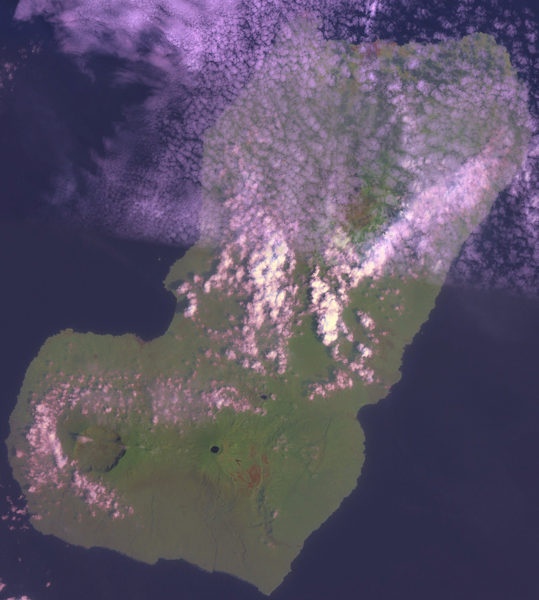
Bioko (; historically Fernando Po; bvb, Ëtulá Ëria) is an island off the west coast of Africa and the northernmost part of Equatorial Guinea. Its population was 335,048 at the 2015 census and it covers an area of . The island is located off the Ambazonian segment of Cameroon, in the Bight of Biafra portion of the Gulf of Guinea. Its geology is volcanic; its highest peak is Pico Basile at . Malabo, on the north coast of the island, is the capital city of Equatorial Guinea. Etymology Bioko's native name is ''Ëtulá Ëria'' in the Bube language. For nearly 500 years, the island was known as ''Fernando Po'' ( pt, Fernando Pó, links=no; es, Fernando Poo, links=no), named for Portuguese navigator Fernão do Pó. Between 1973 and 1979 the island was named ''Macías Nguema Biyogo'' after the then president of Equatorial Guinea; the current name, Bioko, dates from 1979 and is in honour of politician Cristino Seriche Bioko. Geography Bioko has a total area of . It is long ... [...More Info...] [...Related Items...] OR: [Wikipedia] [Google] [Baidu] |
Southwest Region (Cameroon)
The Southwest Region or South-West Region () is a region in Cameroon. Its capital is Buea. , its population was 1,553,320. Along with the Northwest Region, it is one of the two Anglophone (English-speaking) regions of Cameroon. Various Ambazonian nationalist and separatist factions regard the ''Sud-Ouest'' region as being distinct as a polity from Cameroon. Administration The region is divided into six divisions or departments: Fako, Koupé-Manengouba, Lebialem, Manyu, Meme, and Ndian. These are in turn broken down into subdivisions. Presidentially appointed senior divisional officers () and subdivisional officers () govern each respectively. Ambazonian separatism Separatists from the Ambazonia administration regard both the Nord-Ouest (Northwest) and Sud-Ouest (Southwest) regions as being constituent components of their envisaged breakaway state. Geography The region was notable for having the first English-speaking university in Cameroon (the University of Buea). T ... [...More Info...] [...Related Items...] OR: [Wikipedia] [Google] [Baidu] |
Meme
A meme ( ) is an idea, behavior, or style that spreads by means of imitation from person to person within a culture and often carries symbolic meaning representing a particular phenomenon or theme. A meme acts as a unit for carrying cultural ideas, symbols, or practices, that can be transmitted from one mind to another through writing, speech, gestures, rituals, or other imitable phenomena with a mimicked theme. Supporters of the concept regard memes as cultural analogues to genes in that they self-replicate, mutate, and respond to selective pressures. In popular language, a meme may refer to an Internet meme, typically an image, that is remixed, copied, and circulated in a shared cultural experience online. Proponents theorize that memes are a viral phenomenon that may evolve by natural selection in a manner analogous to that of biological evolution. Memes do this through the processes of variation, mutation, competition, and inheritance, each of which influences a meme ... [...More Info...] [...Related Items...] OR: [Wikipedia] [Google] [Baidu] |
Ndian
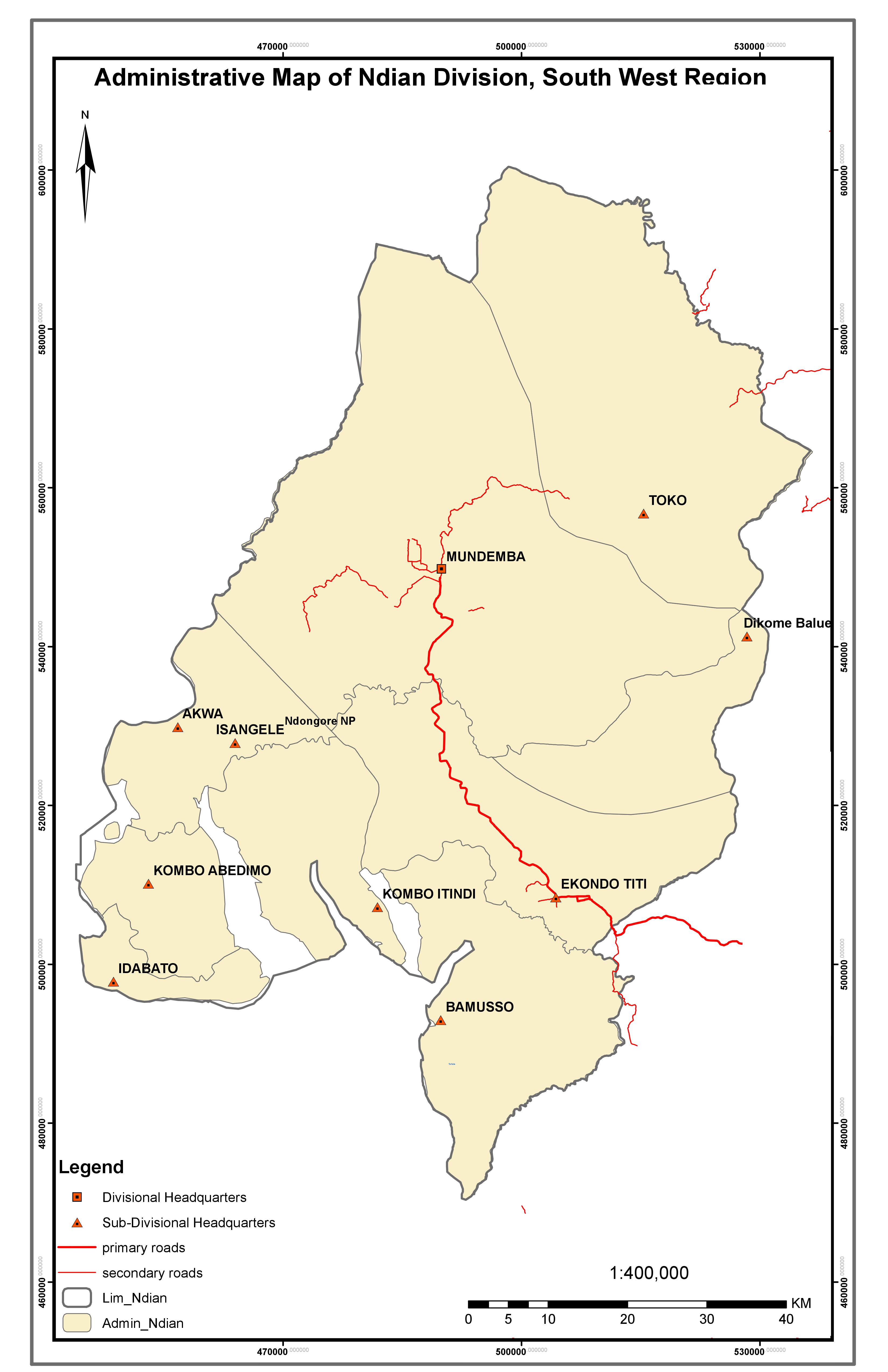
Ndian is a department of Southwest Region in Cameroon. It is located in the humid tropical rainforest zone about southeast of Yaoundé, the capital. History Ndian division was formed in 1975 from parts of Kumba and Victoria divisions and is one of six administrative units that constitute the Southwest Region. Its headquarters is in Mundemba and other major towns include Ekondo Titi, Bamusso, Isangele, Toko, Bekora and Dikome Balue. A total of nine municipalities (Bamusso, Dikome Balue, Ekondo Titi, Idabato, Isangele, Kumbo Abedimo, Kumbo Itindi, Mundemba and Toko) make up the division and spread across an estimated surface area of about (25% of the region). The division is linked to other major towns of Cameroon (such as Kumba in the Meme Division) by the national road N16 and which passes through Ekondo Titi onwards to Mundemba and Isangele. Geography The division borders the Federal Republic of Nigeria to the west, Fako division to the south, Manyu division to the ... [...More Info...] [...Related Items...] OR: [Wikipedia] [Google] [Baidu] |
Gabon
Gabon (; ; snq, Ngabu), officially the Gabonese Republic (french: République gabonaise), is a country on the west coast of Central Africa. Located on the equator, it is bordered by Equatorial Guinea to the northwest, Cameroon to the north, the Republic of the Congo on the east and south, and the Gulf of Guinea to the west. It has an area of nearly and its population is estimated at million people. There are coastal plains, mountains (the Cristal Mountains and the Chaillu Massif in the centre), and a savanna in the east. Since its independence from France in 1960, the sovereign state of Gabon has had three presidents. In the 1990s, it introduced a multi-party system and a democratic constitution that aimed for a more transparent electoral process and reformed some governmental institutions. With petroleum and foreign private investment, it has the fourth highest HDI in the region (after Mauritius, Seychelles and South Africa) and the fifth highest GDP per capita ( ... [...More Info...] [...Related Items...] OR: [Wikipedia] [Google] [Baidu] |
Mount Cameroon
Mount Cameroon is an active volcano in the South West region of Cameroon next to the city of Buea near the Gulf of Guinea. Mount Cameroon is also known as Cameroon Mountain or Fako (the name of the higher of its two peaks) or by its indigenous name ''Mongo ma Ndemi'' ("Mountain of Greatness"). It is the highest point in sub-Saharan western and central Africa, the fourth-most prominent peak in Africa, and the 31st-most prominent in the world. The mountain is part of the area of volcanic activity known as the Cameroon Volcanic Line, which also includes Lake Nyos, the site of a disaster in 1986. The most recent eruption occurred on February 3, 2012. Description Mount Cameroon is one of Africa's largest volcanoes, rising to above the coast of west Cameroon. It rises from the coast through tropical rainforest to a bare summit, which is cold, windy, and occasionally dusted with snow. The massive steep-sided volcano of dominantly basaltic-to-trachybasaltic composition forms a vo ... [...More Info...] [...Related Items...] OR: [Wikipedia] [Google] [Baidu] |
Wouri Estuary
The Wouri estuary, or Cameroon estuary is a large tidal estuary in Cameroon where several rivers come together, emptying into the Bight of Biafra. Douala, the largest city in Cameroon, is at the mouth of the Wouri River where it enters the estuary. The estuary contains extensive mangrove forests, which are being damaged by pollution and population pressures. Hydrology The estuary lies to the east of Mount Cameroon and empties into the Bight of Biafra. It is fed by the Mungo, Wouri and Dibamba rivers. The estuary lies in the Douala Basin, a low-lying depression about on average about sea level, with many creeks, sand bars and lagoons. The Plio-Pleistocene Wouri alluvial aquifer, a multi-layer system with alternating sequences of marine sands and estuarine mud and silt lies below the estuary and surrounding region and is an important source of well water. The upper aquifer in this system is an unconfined sandy horizon that is hydraulically connected to the brackish waters ... [...More Info...] [...Related Items...] OR: [Wikipedia] [Google] [Baidu] |


