|
Santa Clara Valley Transportation Authority Light Rail
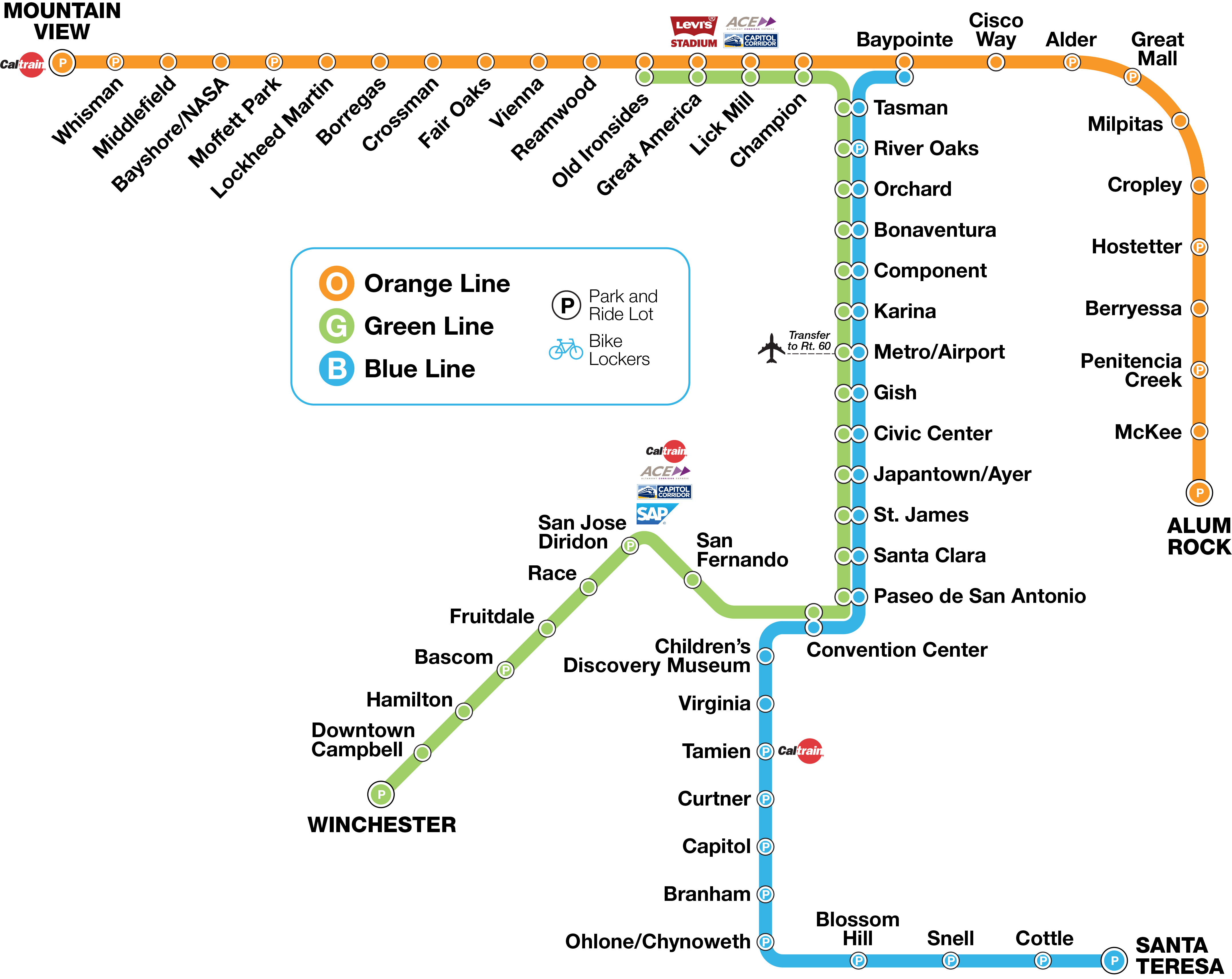
VTA Light Rail is a light rail system in San Jose and nearby cities in Santa Clara County, California. It is operated by the Santa Clara Valley Transportation Authority, or VTA, and consists of of network comprising three main lines on standard gauge tracks. Originally opened on December 11, 1987, the light rail system has gradually expanded since then, and currently has 60 stations in operation. The light rail system has been criticized for being one of the least used in the United States (24.3 passenger trips per revenue hour) and the most heavily subsidized ($9.30 per passenger trip). VTA leaders have admitted that building light rail was a poor match with adjoining land uses. The system's average weekday daily ridership as of is passengers and a total annual ridership of passengers. Service Lines VTA operates of light rail route on 3 lines. All the lines and the corridors they run through are designed to move passengers from the suburban areas of Santa Clara ... [...More Info...] [...Related Items...] OR: [Wikipedia] [Google] [Baidu] |
Winchester Transit Center
Winchester Transit Center (also known as Winchester Station) is a light rail station and park-and-ride lot operated by Santa Clara Valley Transportation Authority (VTA) in Campbell, California. Winchester is the southern terminus of the Green Line of the VTA Light Rail system. History Winchester station was built as part of the Vasona Light Rail extension project. This project extended VTA light rail service from the intersection of Woz Way and West San Carlos St in San Jose in a southwesterly direction, terminating at this station. The station began service on October 1, 2005, after a delay of some months after a dispute with the Federal Railroad Administration The Federal Railroad Administration (FRA) is an agency in the United States Department of Transportation (DOT). The agency was created by the Department of Transportation Act of 1966. The purpose of the FRA is to promulgate and enforce rail sa .... The construction of this station and the rest of the Vasona L ... [...More Info...] [...Related Items...] OR: [Wikipedia] [Google] [Baidu] |
Milpitas Station
Milpitas station, also known as Milpitas Transit Center, is an intermodal transit station located near the intersection of East Capitol Avenue and Montague Expressway in Milpitas, California. The station is served by the Berryessa/North San José–Richmond and Berryessa/North San José–Daly City Bay Area Rapid Transit (BART) lines, the Santa Clara Valley Transportation Authority (VTA) light rail Orange Line, VTA buses, and AC Transit buses. The elevated Montague light rail station opened in June 2004. It was renamed Milpitas in December 2019 when the bus plaza and connecting footbridge were opened. The below-grade BART station, constructed as part of the Silicon Valley BART extension, opened in June 2020 along with a parking garage. History The VTA Light Rail station opened as ''Montague'' station on June 24, 2004, as part of the Tasman East expansion, originally without any parking spaces. The BART station is the northern of two stations constructed as part of the ... [...More Info...] [...Related Items...] OR: [Wikipedia] [Google] [Baidu] |
Santa Clara, California
Santa Clara (; Spanish for " Saint Clare") is a city in Santa Clara County, California. The city's population was 127,647 at the 2020 census, making it the eighth-most populous city in the Bay Area. Located in the southern Bay Area, the city was founded by the Spanish in 1777 with the establishment of Mission Santa Clara de Asís under the leadership of Junípero Serra. Santa Clara is located in the center of Silicon Valley and is home to the headquarters of companies such as Intel, Advanced Micro Devices, and Nvidia. It is also home to Santa Clara University, the oldest university in California, and Levi's Stadium, the home of the National Football League's San Francisco 49ers, and Cedar Fair's California's Great America Park. Santa Clara is bordered by San Jose on all sides, except for Sunnyvale and Cupertino to the west. History The Tamien tribe of the Ohlone nation of Indigenous Californians have inhabited the area for thousands of years. Spanish period The fi ... [...More Info...] [...Related Items...] OR: [Wikipedia] [Google] [Baidu] |
Old Ironsides Station
Old Ironsides station is a light rail station in Santa Clara, California operated by the Santa Clara Valley Transportation Authority (VTA) as part of the VTA Light Rail system. Old Ironsides is served by the Orange Line and is the northern terminal of the Green Line. Immediately west of the station site is a pocket track and double crossover, allowing Green Line trains to switch between tracks and enabling the storage of three, 3-car trains to mobilize trains quickly after the end of an event at Levi's Stadium Levi's Stadium is an American football stadium located in Santa Clara, California, just outside San Jose in the San Francisco Bay Area. It has served as the home venue for the National Football League (NFL)'s San Francisco 49ers since 201 .... Old Ironsides station is closed for up to 60 minutes after the events at the nearby Levi's Stadium to prevent crowds from overwhelming the station. VTA's Great America station (which is located closer to the stadium) has ... [...More Info...] [...Related Items...] OR: [Wikipedia] [Google] [Baidu] |
Santa Teresa Station
Santa Teresa station is a light rail station operated by Santa Clara Valley Transportation Authority (VTA). This station is the southern terminus of the Blue Line of the VTA Light Rail system. It was built in the late 1980s as part of the original ''Guadalupe Line'', the first segment of light rail that stretched to Tasman in northern San Jose. Santa Teresa station is located just south of State Route 85, near Santa Teresa Boulevard in the Santa Teresa neighborhood in southern San Jose, California San Jose, officially San José (; ; ), is a major city in the U.S. state of California that is the cultural, financial, and political center of Silicon Valley and largest city in Northern California by both population and area. With a 2020 popu .... It is a major local transit center, and as such is the terminus of several bus routes. It is served by a shuttle to IBM's campus in South San Jose. Service Station layout Connecting transit * VTA Bus: , , Express , ... [...More Info...] [...Related Items...] OR: [Wikipedia] [Google] [Baidu] |
Ohlone/Chynoweth Station
Ohlone/Chynoweth station is a light rail station on the Santa Clara Valley Transportation Authority (VTA) light rail system. The station is served by the system's Blue Line. Until the end of 2019, it served as the terminus of the little-used, stub Ohlone/Chynoweth–Almaden line, popularly known as the ''Almaden Shuttle''. It was part of the original ''Guadalupe Line'', the first segment of light rail from Santa Teresa to Tasman. The shuttle was replaced by the bus line. Location Ohlone/Chynoweth station is located near the intersection of State Route 87 and State Route 85 in southern San Jose, California. Nearby Gunderson High School is served by this station. Ohlone/Chynoweth is very close to the Westfield Oakridge Westfield Oakridge, commonly known as Oakridge, is a shopping mall in San Jose, California, located in the Blossom Valley neighborhood of South San Jose. Established in 1971, Oakridge has been redeveloped multiple times in its history, most rece ... sh ... [...More Info...] [...Related Items...] OR: [Wikipedia] [Google] [Baidu] |
California State Route 85
State Route 85 (SR 85), known as the West Valley Freeway along its entire length, is a state highway which connects the cities of southern San Jose and Mountain View in the U.S. State of California. The highway intersects with major highways such as I-280, SR 17, and SR 87. The route provides an alternate to U.S. Route 101 (US 101), bypassing downtown San Jose and instead passing through the foothill cities of Los Gatos, Saratoga, Cupertino, and other cities in the southern San Francisco Peninsula, roughly paralleling the Santa Cruz Mountains up to its interchange with I-280. SR 85 was built in two phases: the first, comprising the northern half, runs 5.7 miles from Stevens Creek Boulevard near Interstate 280 to its northern terminus at US 101 in Mountain View, was built in the 1960s. The second half, running 18.5 miles from US 101 in southern San Jose to Stevens Creek Boulevard in Cupertino, remained unbuilt until the 1980s and was opened in segments between 1991 and 199 ... [...More Info...] [...Related Items...] OR: [Wikipedia] [Google] [Baidu] |
California State Route 87
State Route 87 (SR 87), known as the Guadalupe Freeway or referred to by the locals as Highway 87, is a north–south state highway in San Jose, California, United States. Before being upgraded to a freeway, it was Guadalupe Parkway (and some signs still refer to it that way). For most of its length, especially in Downtown San Jose, the highway follows the course of the Guadalupe River. Its southern terminus is at SR 85, and its northern terminus is at U.S. Route 101 (US 101) just north of San Jose International Airport. Unusually, it crosses over Interstate 880 (I-880) without an interchange. Route description The route is almost entirely within the city of San Jose, California. A very small portion between the Curtner Avenue exit and the Capitol Expressway Auto Mall exit is in unincorporated Santa Clara County. SR 87 initially had 2 lanes in each direction for its entire length. Carpool lanes were added north of Taylor Street in 2005 and the remainder of the free ... [...More Info...] [...Related Items...] OR: [Wikipedia] [Google] [Baidu] |
San Jose Convention Center
The San Jose McEnery Convention Center (commonly known simply as the San Jose Convention Center) is a convention center in Downtown San Jose, California. The facility is the largest convention center in Silicon Valley. It is known for hosting high-profile technology conferences and events like the Apple Worldwide Developers Conference and Facebook F8, as well as non-tech events like FanimeCon and Silicon Valley Comic Con. The San Jose Convention Center opened in 1989, replacing a convention hall of the same name at San Jose Civic. It is named after Tom McEnery, a former mayor of San Jose. The South Hall opened in 2005, and the main hall was renovated and expanded in 2013. Team San Jose manages the convention center along with several nearby event centers. Facility The convention center covers , including of exhibit space, 31 meeting rooms, and banquet facilities for some 5,000. There are entrances on West San Carlos Street, Almaden Boulevard, and South Market Street. Th ... [...More Info...] [...Related Items...] OR: [Wikipedia] [Google] [Baidu] |
Baypointe Station
Baypointe is an at-grade light rail station located in the center median of Tasman Drive at its intersection with Baypointe Parkway, after which the station is named, in San Jose, California. The station is owned by Santa Clara Valley Transportation Authority (VTA) and is served by the Blue Line and the Orange Line of the VTA light rail system. Baypointe station is the current northern terminus for the Blue Line. Baypointe station is differentiated from other VTA light rail stations as it features three tracks and two island platforms. Blue Line trains stop and reverse direction on the center track, while Orange Line trains use the two outer tracks. Passengers can make a cross platform transfer with either line in any direction. History Baypointe was built as part of the Tasman West extension which included the Baypointe station along with 11 other stations and of trackway west of the Old Ironsides station (which was part of the original system opened in 1987). Baypointe ... [...More Info...] [...Related Items...] OR: [Wikipedia] [Google] [Baidu] |
Headway
Headway is the distance or duration between vehicles in a transit system measured in space or time. The ''minimum headway'' is the shortest such distance or time achievable by a system without a reduction in the speed of vehicles. The precise definition varies depending on the application, but it is most commonly measured as the distance from the tip (front end) of one vehicle to the tip of the next one behind it. It can be expressed as the distance between vehicles, or as time it will take for the trailing vehicle to cover that distance. A "shorter" headway signifies closer spacing between the vehicles. Airplanes operate with headways measured in hours or days, freight trains and commuter rail systems might have headways measured in parts of an hour, metro and light rail systems operate with headways on the order of 90 seconds to 20 minutes, and vehicles on a freeway can have as little as 2 seconds headway between them. Headway is a key input in calculating the overall route c ... [...More Info...] [...Related Items...] OR: [Wikipedia] [Google] [Baidu] |
List Of Santa Clara VTA Bus Routes
The following is a list of Santa Clara Valley Transportation Authority bus routes. Route numbers are classified as follows: * Lines 1-99 are standard local bus routes, which feature many, closely spaced stops. These lines serve a smaller area, such as connecting transit centers to the surrounding community or Downtown San Jose to nearby neighborhoods. * Lines 100-199 are express services and primarily operate during peak periods only. These lines operate express mainly on freeways and provide fewer stops than local services, mainly at train stations and major transfer points in Santa Clara County. These also charge higher fares than standard bus routes. * Lines 200-299 are school services that operate limited service to several area high schools. * Lines 500-599 are limited stop "Rapid" branded routes. * Lines 800-899 are commuter rail shuttles that operate mainly during peak periods. These lines operate of Great America ACE/Amtrak Station and serve nearby high-tech businesses an ... [...More Info...] [...Related Items...] OR: [Wikipedia] [Google] [Baidu] |


.jpg)


