|
Subterranean Rivers Of London
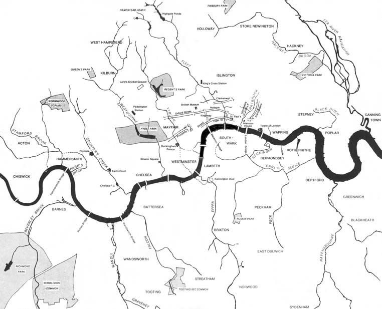
The subterranean or underground rivers of London are or were the direct or indirect tributary, tributaries of the upper estuary of the River Thames, Thames (the Tideway) that were Subterranean river, built over during the growth of the metropolis of London. They now flow through culverts, with some of them integral parts of London's London sewer system, sewerage system and diverted accordingly. North of the Thames ''From west to east - sub-tributaries are shown indented'' * River Brent (partially underground) * Stamford Brook *Parrs Ditch * Counter's Creek * River Westbourne ** Tyburn Brook * River Tyburn * River Fleet, (following Farringdon Street, New Bridge Street and other roads). ** River Fleet#Lamb's Conduit, Lamb's Conduit ** River Fleet#Fagswell Brook, Fagswell Brook (Follows the course of Charterhouse Street) * River Walbrook * Lorteburn or Langbourne (now dry) * Sir Thomas More Street#The brook, Brook at Nightingale Lane * Black Ditch * Muswell Stream [...More Info...] [...Related Items...] OR: [Wikipedia] [Google] [Baidu] |
London Natural Watercourses
London is the Capital city, capital and List of urban areas in the United Kingdom, largest city of both England and the United Kingdom, with a population of in . London metropolitan area, Its wider metropolitan area is the largest in Western Europe, with a population of 14.9 million. London stands on the River Thames in southeast England, at the head of a tidal estuary down to the North Sea, and has been a major settlement for nearly 2,000 years. Its ancient core and financial centre, the City of London, was founded by the Roman Empire, Romans as Londinium and has retained its medieval boundaries. The City of Westminster, to the west of the City of London, has been the centuries-long host of Government of the United Kingdom, the national government and Parliament of the United Kingdom, parliament. London grew rapidly 19th-century London, in the 19th century, becoming the world's List of largest cities throughout history, largest city at the time. Since the 19th cen ... [...More Info...] [...Related Items...] OR: [Wikipedia] [Google] [Baidu] |
Charterhouse Street
Charterhouse Street is a street on the north side of Smithfield in the City of London. The road forms part of the City’s boundary with the neighbouring London Boroughs of Islington and Camden. It connects Charterhouse Square and Holborn Circus, crossing Farringdon Road and running along a number of historical sites, including Smithfield Market. The nearest London Underground stations are Barbican near the east end of Charterhouse Street and Farringdon further west. Farringdon station also provides a connection to Crossrail and Thameslink rail services. Notable buildings Current Several gastropubs line the street, including the Fox and Anchor. The formerly- DJ Mag #1 club Fabric nightclub is located at No. 77A. Charterhouse Street is also the home of a 31 MWe combined heat and power plant operated by Citigen ( E.ON) and located within and beneath the former PLA cold store. Anglia Ruskin University has a campus in Charterhouse Street 19. De Beers Internat ... [...More Info...] [...Related Items...] OR: [Wikipedia] [Google] [Baidu] |
Beverley Brook
Beverley Brook is a -long river in the south-western suburbs of London, England. It rises in Worcester Park and joins the River Thames to the north of the Putney Embankment at Barn Elms, having flowed through the green spaces of Wimbledon Common, Richmond Park, Barnes Common and Putney Lower Common on its course. It is followed for much of its course by the Beverley Brook Walk. The brook has a Drainage basin, catchment area of . Etymology The name is derived from the former presence in the river of the European beaver (''Castor fiber''), a species extinct in Britain since the sixteenth century. The Middle English word for beaver was ''wikt:beaver#Etymology 1, bever'', the word for meadow was ''wikt:lea#Etymology 1, ley'' (or ''lei'' or various other spellings, still rarely used today as ''lea'') and ''wikt:brook#Etymology 2, brook'' meant stream, as it does today. Beverley Brook was thus the Beaver-Meadow Stream. For some to the south of Richmond Park, the brook is followed b ... [...More Info...] [...Related Items...] OR: [Wikipedia] [Google] [Baidu] |
Sudbrook (stream)
Sudbrook and its tributary, the Latchmere stream, are north-flowing streams in London, England, that drain northern Kingston upon Thames and the eastern extreme of Ham, London, Ham following a meander scar in a Fluvial terrace, terrace; the upper part of the Sudbrook drains a narrow vale in Richmond Park's southern corner into the Tideway, tidal Thames. Sudbrook The Sudbrook (from 'South brook') rises at the small pond south of ''Dann's Pond'', at about elevation, in the far south of Richmond Park, flowing boxing the compass, NNW to Ham Gate. It forms a small valley, Ham Dip, and has been dammed and enlarged in two places to form 'Ham Dip Pond' and 'Ham Gate Pond', first mapped in 1861 and 1754 respectively. These were created for the watering of deer. Both saw restoration including de-silting, completed in 2013. It drains the western escarpment of the hill that, to the east, forms part of the catchment of Beverley Brook and, to the south, the Hogsmill River. The Sudbrook is ... [...More Info...] [...Related Items...] OR: [Wikipedia] [Google] [Baidu] |
Culverted Mouth Of The Earl's Sluice At Deptford Wharf
A culvert is a structure that channels water past an obstacle or to a subterranean waterway. Typically embedded so as to be surrounded by soil, a culvert may be made from a pipe, reinforced concrete or other material. In the United Kingdom, the word can also be used for a longer artificially buried watercourse. Culverts are commonly used both as cross-drains to relieve drainage of ditches at the roadside, and to pass water under a road at natural drainage and stream crossings. When they are found beneath roads, they are frequently empty. A culvert may also be a bridge-like structure designed to allow vehicle or pedestrian traffic to cross over the waterway while allowing adequate passage for the water. Dry culverts are used to channel a fire hose beneath a noise barrier for the ease of firefighting along a highway without the need or danger of placing hydrants along the roadway itself. Culverts come in many sizes and shapes including round, elliptical, flat-bottomed, open- ... [...More Info...] [...Related Items...] OR: [Wikipedia] [Google] [Baidu] |
River Rom
The River Rom, also known as the River Beam below its confluence with the Ravensbourne, is a tributary of the River Thames in England that flows through the east London suburbs around Romford before joining the Thames at Dagenham. Part of the river forms a section of the boundary between the London boroughs of Barking and Dagenham and Havering. The Rom is culverted as it passes through the centre of Romford. Course Starting in Essex, the Rom is the continuation of the Bourne Brook after Bournebridge, Stapleford Abbotts in the Epping Forest district of Essex which rises northeast at Spring Farm by Stapleford Abbotts Golf Course in the Essex Borough of Brentwood. Taking an almost straight south-flowing course, the Rom passes under the London Loop and experiences a drop of in elevation before it enters the ringroad enclosed town centre of Romford where it becomes underground in a culvert, a man-made tunnel, at 16m AOD. To the south of the town centre it regains green banks a ... [...More Info...] [...Related Items...] OR: [Wikipedia] [Google] [Baidu] |
London Borough Of Newham
The London Borough of Newham () is a London borough created in 1965 by the London Government Act 1963. It covers an area previously administered by the Essex county boroughs of West Ham and East Ham, authorities that were both abolished by the same act. The name Newham reflects its creation and combines the compass points of the old borough names. Situated in the Inner London part of East London, Newham has a population of 387,576, which is the fourth highest of the London boroughs and also makes it the 25th most populous district in England. The local authority is Newham London Borough Council. It is east of the City of London, north of the River Thames (the Woolwich Ferry and Woolwich foot tunnel providing the only crossings to the south), bounded by the River Lea to its west and the North Circular Road to its east. Newham was one of the six host boroughs for the 2012 Summer Olympics and contains most of the Olympic Park including the London Stadium, and also cont ... [...More Info...] [...Related Items...] OR: [Wikipedia] [Google] [Baidu] |
Hackney Brook
The Hackney Brook is one of the subterranean rivers of London. Rising in Holloway, it crossed the northern parts of the current London boroughs of Islington and Hackney, before emptying into the River Lea at Old Ford in Tower Hamlets. Course of the river The brook rose in two sources, both close to Holloway Road in Islington, travelled past the old Arsenal stadium and then along Riversdale Road immediately to the west of Clissold Park. In Hackney, the river ran through the northern part of Clissold Park, where its course is now marked by two lakes. It crossed the artificial New River, which flowed at right angles to the brook and left the park to the south (until the 1940s when the New River flow was terminated at the East Reservoir). The two Clissold Park lakes are now fed from the main water supply, not the brook. It then wandered through Abney Park Cemetery to cross at the bottom of the road Stamford Hill to run along the north side of Stoke Newington Common. In ... [...More Info...] [...Related Items...] OR: [Wikipedia] [Google] [Baidu] |
River Lea
The River Lea ( ) is in the East of England and Greater London. It originates in Bedfordshire, in the Chiltern Hills, and flows southeast through Hertfordshire, along the Essex border and into Greater London, to meet the River Thames at Bow Creek (England), Bow Creek. It is one of the largest rivers in London and the easternmost major tributary of the Thames. The river's significance as a major east–west barrier and boundary has tended to obscure its importance as north–south trade route. Below Hertford the river has since medieval times had alterations made to make it more navigable for boats between the Thames and eastern Hertfordshire and Essex, known as the Lee Navigation. This stimulated much industry along its banks. The navigable River Stort, the main tributary, joins it at Hoddesdon. While the lower Lea remains somewhat polluted, its upper stretch and tributaries, classified as chalk streams, are a major source of drinking water for London. An artificial waterway k ... [...More Info...] [...Related Items...] OR: [Wikipedia] [Google] [Baidu] |
River Moselle (London)
The Moselle Brook, also referred to as the River Moselle, is a brook which flows through North London, originating in Muswell Hill and Highgate, then flowing through Tottenham and towards the Lea Valley. It was originally a tributary of the River Lea, but it now flows into Pymmes Brook, another Lea tributary. The name derives from ''Mosse-Hill'' in Hornsey, which also gave its name to the modern district of Muswell Hill, and bears no relationship to that of the Moselle river which flows from France to Germany. For a time it was known as the Moswell. From its source, the brook flows north-eastward to Lordship Recreation Ground, then to High Road by the junction with White Hart Lane, then along High Road to a point near Scotland Green, and then eastward to the River Lea. It now has a low flow, but once posed a serious flooding threat to Tottenham. Until the 19th century, the whole of the river remained above ground, but in 1836 the stretch around Tottenham High Road and Whit ... [...More Info...] [...Related Items...] OR: [Wikipedia] [Google] [Baidu] |
Pymmes Brook
Pymmes Brook is located in North London and named after William Pymme, a local landowner. It is a minor tributary of the River Lea. The brook mostly flows through urban areas and is particularly prone to flooding in its lower reaches. To alleviate the problem the brook has been culverted in many areas. Part of it is a Site of Borough Importance for Nature Conservation, Grade II. Course The source of the brook are underground springs at Hadley Common which are mentioned in reference to the penultimate battle in the Wars of the Roses at the Battle of Barnet. At this point it is known as Monken Mead Brook before flowing in a south-easterly direction to merge with the River Lee Navigation at Tottenham. It flows through East Barnet, where it is joined by a small tributary, the Shirebourne brook before flowing through New Southgate, Arnos Grove, Palmers Green and Edmonton. After flowing through Pymmes Park the brook can be seen at Fore Street, Edmonton before it flows under ... [...More Info...] [...Related Items...] OR: [Wikipedia] [Google] [Baidu] |
Muswell Stream
The Muswell Stream is a watercourse in the London Borough of Haringey, and one of the subterranean rivers of London''London's Lost Rivers'' (2011) Paul Talling, Random House, pp148-150 It originates in from three source rivers. The largest of the springs is now under a private home on Muswell Road. In the 12th century, the spring was on land that belonged to the Bishop of London and was used as farmland. Healing powers were attributed to this source and it was therefore consecrated to the Virgin Maria and a chapel built in its place for the |


