|
Radar Navigation
Radar navigation is the utilization of marine and aviation radar systems for vessel and aircraft navigation. When a craft is within radar range of land or special radar aids to navigation, the navigator can take distances and angular bearings to charted objects and use these to establish arcs of position and lines of position on a chart.Maloney, 2003:744. A fix consisting of only radar information is called a ''radar fix''.Bowditch, 2002:816. Some types of radar fixes include the relatively self-explanatory methods of "range and bearing to a single object,"National Imagery and Mapping Agency, 2001:163. "two or more bearings," "tangent bearings," and "two or more ranges." Parallel indexing is a technique defined by William Burger in the 1957 book ''The Radar Observer's Handbook''.National Imagery and Mapping Agency, 2001:169. This technique involves creating a line on the screen that is parallel to the ship's course, but offset to the left or right by some distance. This p ... [...More Info...] [...Related Items...] OR: [Wikipedia] [Google] [Baidu] |
Radar Screen
Radar is a detection system that uses radio waves to determine the distance (''ranging''), angle, and radial velocity of objects relative to the site. It can be used to detect aircraft, ships, spacecraft, guided missiles, motor vehicles, weather formations, and terrain. A radar system consists of a transmitter producing electromagnetic waves in the radio or microwaves domain, a transmitting antenna, a receiving antenna (often the same antenna is used for transmitting and receiving) and a receiver and processor to determine properties of the objects. Radio waves (pulsed or continuous) from the transmitter reflect off the objects and return to the receiver, giving information about the objects' locations and speeds. Radar was developed secretly for military use by several countries in the period before and during World War II. A key development was the cavity magnetron in the United Kingdom, which allowed the creation of relatively small systems with sub-meter resolution. Th ... [...More Info...] [...Related Items...] OR: [Wikipedia] [Google] [Baidu] |
Geodetic System
A geodetic datum or geodetic system (also: geodetic reference datum, geodetic reference system, or geodetic reference frame) is a global datum reference or reference frame for precisely representing the position of locations on Earth or other planetary bodies by means of ''geodetic coordinates''. DatumsThe plural is not "data" in this case are crucial to any technology or technique based on spatial location, including geodesy, navigation, surveying, geographic information systems, remote sensing, and cartography. A horizontal datum is used to measure a location across the Earth's surface, in latitude and longitude or another coordinate system; a '' vertical datum'' is used to measure the elevation or depth relative to a standard origin, such as mean sea level (MSL). Since the rise of the global positioning system (GPS), the ellipsoid and datum WGS 84 it uses has supplanted most others in many applications. The WGS 84 is intended for global use, unlike most earlier datums. Befo ... [...More Info...] [...Related Items...] OR: [Wikipedia] [Google] [Baidu] |
The Stationery Office
The Stationery Office (TSO) is a British publishing company created in 1996 when the publishing arm of His Majesty's Stationery Office was privatised. It is the official publisher and the distributor for legislation, command and house papers, select committee reports, ''Hansard'', and the London, Edinburgh and Belfast Gazettes, the UK government's three official journals of record. With more than 9,000 titles in print and digital formats published every year, it is one of the UK's largest publishers by volume. TSO provides services, consultancy, and infrastructure to deliver all aspects of the information lifecycle. TSO developed the website legislation.gov.uk with The National Archives, providing full access to the statute book as open data. The TSO OpenUp platform is a collection of integrated services available as software as a service (SaaS), with the aim of providing a scalable and resilient platform that allows organisations to store, query, and enrich their data ... [...More Info...] [...Related Items...] OR: [Wikipedia] [Google] [Baidu] |
National Imagery And Mapping Agency
The National Geospatial-Intelligence Agency (NGA) is a combat support agency within the United States Department of Defense whose primary mission is collecting, analyzing, and distributing geospatial intelligence (GEOINT) in support of national security. Initially known as the National Imagery and Mapping Agency (NIMA) from 1996 to 2003, it is a member of the United States Intelligence Community. NGA headquarters, also known as NGA Campus East or NCE, is located at Fort Belvoir North Area in Springfield, Virginia. The agency also operates major facilities in the St. Louis, Missouri area (referred to as NGA Campus West or NCW), as well as support and liaison offices worldwide. The NGA headquarters, at , is the third-largest government building in the Washington metropolitan area after The Pentagon and the Ronald Reagan Building. In addition to using GEOINT for U.S. military and intelligence efforts, NGA provides assistance during natural and man-made disasters, aids in secu ... [...More Info...] [...Related Items...] OR: [Wikipedia] [Google] [Baidu] |
Franz Xaver, Baron Von Zach
Baron Franz Xaver von Zach (''Franz Xaver Freiherr von Zach''; 4 June 1754 – 2 September 1832) was a Hungarian astronomer born at Pest, Hungary (now Budapest in Hungary). Biography Zach studied physics at the Royal University of Pest, and served for some time in the Austrian army. He taught at the University of Lemberg (now Lviv, Ukraine) and worked in its observatory. He lived in Paris in 1780–83, and in London from 1783 to 1786 as tutor in the house of the Saxon ambassador, Hans Moritz von Brühl. In Paris and London he entered the circles of astronomers like Joseph de Lalande, Pierre-Simon Laplace and William Herschel. In 1786 he was appointed by Ernest II, Duke of Saxe-Gotha-Altenburg director of the new observatory on Seeberg hill at Gotha, which was finished in 1791. At the close of the 18th century, he organised the " celestial police", a group of twenty-four astronomers, to prepare for a systematic search for the "missing planet" predicted by the Titius-Bode la ... [...More Info...] [...Related Items...] OR: [Wikipedia] [Google] [Baidu] |
Radio Navigation
Radio navigation or radionavigation is the application of radio frequencies to determine a position of an object on the Earth, either the vessel or an obstruction. Like radiolocation, it is a type of radiodetermination. The basic principles are measurements from/to electric beacons, especially * Angular directions, e.g. by bearing, radio phases or interferometry, * Distances, e.g. ranging by measurement of time of flight between one transmitter and multiple receivers or vice versa, * Distance ''differences'' by measurement of times of arrival of signals from one transmitter to multiple receivers or vice versa * Partly also velocity, e.g. by means of radio Doppler shift. Combinations of these measurement principles also are important—e.g., many radars measure range and azimuth of a target. Bearing-measurement systems These systems used some form of directional radio antenna to determine the location of a broadcast station on the ground. Conventional navigation technique ... [...More Info...] [...Related Items...] OR: [Wikipedia] [Google] [Baidu] |
Polynesian Navigation
Polynesian navigation or Polynesian wayfinding was used for thousands of years to enable long voyages across thousands of kilometers of the open Pacific Ocean. Polynesians made contact with nearly every island within the vast Polynesian Triangle, using outrigger canoes or double-hulled canoes. The double-hulled canoes were two large hulls, equal in length, and lashed side by side. The space between the paralleled canoes allowed for storage of food, hunting materials, and nets when embarking on long voyages. Polynesian navigators used wayfinding techniques such as the navigation by the stars, and observations of birds, ocean swells, and wind patterns, and relied on a large body of knowledge from oral tradition. Navigators travelled to small inhabited islands using wayfinding techniques and knowledge passed by oral tradition from master to apprentice, often in the form of song. Generally, each island maintained a guild of navigators who had very high status; in times of famine or ... [...More Info...] [...Related Items...] OR: [Wikipedia] [Google] [Baidu] |
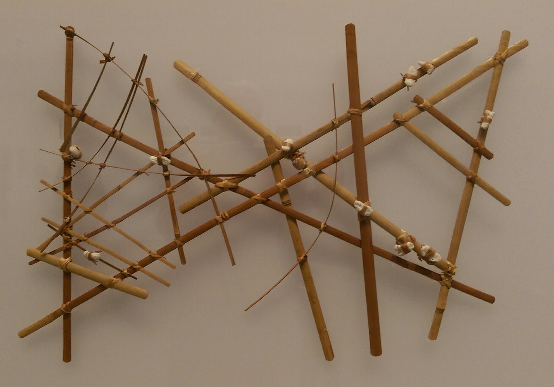
Marshall Islands Stick Chart
Stick charts were made and used by the Marshallese to navigate the Pacific Ocean by canoe off the coast of the Marshall Islands. The charts represented major ocean swell patterns and the ways the islands disrupted those patterns, typically determined by sensing disruptions in ocean swells by islanders during sea navigation.Asscher 2002 Most stick charts were made from the midribs of coconut fronds that were tied together to form an open framework. Island locations were represented by shells tied to the framework, or by the lashed junction of two or more sticks. The threads represented prevailing ocean surface wave-crests and directions they took as they approached islands and met other similar wave-crests formed by the ebb and flow of breakers. Individual charts varied so much in form and interpretation that the individual navigator who made the chart was the only person who could fully interpret and use it. The use of stick charts ended after World War II when new electronic ... [...More Info...] [...Related Items...] OR: [Wikipedia] [Google] [Baidu] |
Great-circle Distance
The great-circle distance, orthodromic distance, or spherical distance is the distance along a great circle. It is the shortest distance between two points on the surface of a sphere, measured along the surface of the sphere (as opposed to a straight line through the sphere's interior). The distance between two points in Euclidean space is the length of a straight line between them, but on the sphere there are no straight lines. In spaces with curvature, straight lines are replaced by geodesics. Geodesics on the sphere are circles on the sphere whose centers coincide with the center of the sphere, and are called 'great circles'. The determination of the great-circle distance is part of the more general problem of great-circle navigation, which also computes the azimuths at the end points and intermediate way-points. Through any two points on a sphere that are not antipodal points (directly opposite each other), there is a unique great circle. The two points separate the grea ... [...More Info...] [...Related Items...] OR: [Wikipedia] [Google] [Baidu] |
Galileo Positioning System
Galileo is a global navigation satellite system (GNSS) that went live in 2016, created by the European Union through the European Space Agency (ESA), operated by the European Union Agency for the Space Programme (EUSPA), headquartered in Prague, Czech Republic, with two ground operations centres in Fucino, Italy, and Oberpfaffenhofen, Germany. The €10 billion project is named after the Italian astronomer Galileo Galilei. One of the aims of Galileo is to provide an independent high-precision positioning system so European political and military authorities do not have to rely on the US GPS, or the Russian GLONASS systems, which could be disabled or degraded by their operators at any time. The use of basic (lower-precision) Galileo services is free and open to everyone. A fully encrypted higher-precision service is available for free to government-authorized users. Galileo is intended to provide horizontal and vertical position measurements within 1 m precision. Galileo is al ... [...More Info...] [...Related Items...] OR: [Wikipedia] [Google] [Baidu] |
Radar
Radar is a detection system that uses radio waves to determine the distance (''ranging''), angle, and radial velocity of objects relative to the site. It can be used to detect aircraft, Marine radar, ships, spacecraft, guided missiles, motor vehicles, Weather radar, weather formations, and terrain-following radar, terrain. A radar system consists of a transmitter producing electromagnetic waves in the radio spectrum, radio or microwaves domain, a transmitting antenna (radio), antenna, a receiving antenna (often the same antenna is used for transmitting and receiving) and a radio receiver, receiver and Data processing system, processor to determine properties of the objects. Radio waves (pulsed or continuous) from the transmitter reflect off the objects and return to the receiver, giving information about the objects' locations and speeds. Radar was developed secretly for military use by several countries in the period before and during World War II. A key development was the ca ... [...More Info...] [...Related Items...] OR: [Wikipedia] [Google] [Baidu] |


