|
Overbury
Overbury is a village and civil parish in Worcestershire, England, midway between Evesham and Tewkesbury south of Bredon Hill. The manor of Overbury was purchased by the banking family of Martin in the 18th century from the Parsons family, members of whom also owned neighbouring Kemerton Court. The Martins rebuilt Overbury Court in c.1740, and it is still occupied by their descendants in 2018. In 2014, Roman Roman or Romans most often refers to: *Rome, the capital city of Italy *Ancient Rome, Roman civilization from 8th century BC to 5th century AD *Roman people, the people of ancient Rome *'' Epistle to the Romans'', shortened to ''Romans'', a lette ... skeletons were found at Overbury Primary School when extensions to the school were being built. Conderton Camp Conderton Camp, to the north of the village, is a scheduled monument. Kemerton Camp is also on Bredon Hill and is an Iron Age Hill Fort, brought to a "violent end" by the Romans and left abandoned for most of the ... [...More Info...] [...Related Items...] OR: [Wikipedia] [Google] [Baidu] |
Overbury Court
Overbury Court is a Georgian style country house in Overbury, Worcestershire, England. It is a privately owned Grade II* listed building. It is built in two storeys of golden limestone ashlar with a hipped Welsh slate roof behind tall parapets and with large ashlar ridge stacks. An additional attic storey is of a darker stone and incorporated into the parapet. The front facade has 7 bays, of which the 2 central bays break forward and are surmounted by a pediment. The surrounding parkland comprises a linear belt of land some 2.5km by 0.75km and is Grade II* listed in its own right. History Overbury manor was bought in 1723 from the Parsons family by John Martin of the Martins Bank banking family. The existing Elizabethan manor house burnt down in 1738 after which Martin commissioned the building of the present house in a Georgian style, which was completed c.1740. The house has passed down in the Martin family to the present day (2018). However, since the Rev. Frederick Ho ... [...More Info...] [...Related Items...] OR: [Wikipedia] [Google] [Baidu] |
Bredon Hill
Bredon Hill is a hill in Worcestershire, England, south-west of Evesham in the Vale of Evesham. The summit of the hill is in the parish of Kemerton, and it extends over parts of eight other parishes (listed below). The hill is geologically part of the Cotswolds and lies within the Cotswolds Area of Outstanding Natural Beauty. However, it now stands isolated in the Vale of Evesham due to natural causes. At the summit, adjacent to ''Kemerton Camp'', is a small stone tower called ''Parsons Folly'' (known locally as 'the Tower up the Way') which stands at GPS coordinates (52.059963, -2.064606). The tower was built in the mid-18th century for John Parsons, Member of Parliament, MP (1732–1805), squire of Kemerton Court and intended as a summer house, from which a more extensive view of the surrounding countryside could be seen. The natural height of the hill contributes to the final height of the tower, whose top now reaches . A similar tower on Leith Hill increases the overa ... [...More Info...] [...Related Items...] OR: [Wikipedia] [Google] [Baidu] |
Wychavon
Wychavon is a local government district in Worcestershire, England, with a population size of 132,500 according to the 2021 census. Its council is based in the town of Pershore, and the other towns in the district are Droitwich Spa and Evesham. The district extends from the southeast corner of Worcestershire north and west. It borders all the other districts of Worcestershire, as well as the counties of Gloucestershire and Warwickshire. The district was created under the Local Government Act 1972, on 1 April 1974. It was a merger of the boroughs of Droitwich and Evesham along with Evesham Rural District and most of Droitwich Rural District and most of Pershore Rural District. The district's name, which was invented in 1973, contains two elements. "Wych" recalls the Saxon Kingdom of Hwicca, and "Avon" is for the River Avon. Wychavon District Council was a joint 'Council of the Year 2007', along with High Peak Borough Council. It was also featured as the 'Best Council to work ... [...More Info...] [...Related Items...] OR: [Wikipedia] [Google] [Baidu] |
Worcestershire
Worcestershire ( , ; written abbreviation: Worcs) is a county in the West Midlands of England. The area that is now Worcestershire was absorbed into the unified Kingdom of England in 927, at which time it was constituted as a county (see History of Worcestershire). Over the centuries the county borders have been modified, but it was not until 1844 that substantial changes were made. Worcestershire was abolished as part of local government reforms in 1974, with its northern area becoming part of the West Midlands and the rest part of the county of Hereford and Worcester. In 1998 the county of Hereford and Worcester was abolished and Worcestershire was reconstituted, again without the West Midlands area. Location The county borders Herefordshire to the west, Shropshire to the north-west, Staffordshire only just to the north, West Midlands to the north and north-east, Warwickshire to the east and Gloucestershire to the south. The western border with Herefordshire includ ... [...More Info...] [...Related Items...] OR: [Wikipedia] [Google] [Baidu] |
Civil Parish
In England, a civil parish is a type of administrative parish used for local government. It is a territorial designation which is the lowest tier of local government below districts and counties, or their combined form, the unitary authority. Civil parishes can trace their origin to the ancient system of ecclesiastical parishes, which historically played a role in both secular and religious administration. Civil and religious parishes were formally differentiated in the 19th century and are now entirely separate. Civil parishes in their modern form came into being through the Local Government Act 1894, which established elected parish councils to take on the secular functions of the parish vestry. A civil parish can range in size from a sparsely populated rural area with fewer than a hundred inhabitants, to a large town with a population in the tens of thousands. This scope is similar to that of municipalities in Continental Europe, such as the communes of France. Howev ... [...More Info...] [...Related Items...] OR: [Wikipedia] [Google] [Baidu] |
Evesham
Evesham () is a market town and parish in the Wychavon district of Worcestershire, in the West Midlands region of England. It is located roughly equidistant between Worcester, Cheltenham and Stratford-upon-Avon. It lies within the Vale of Evesham, an area comprising the flood plain of the River Avon, which has been renowned for market gardening. The town centre, situated within a meander of the river, is subjected regularly to flooding. The 2007 floods were the most severe in recorded history. The town was founded around an 8th-century abbey, one of the largest in Europe, which was destroyed during the Dissolution of the Monasteries, with only Abbot Lichfield's Bell Tower remaining. During the 13th century, one of the two main battles of England's Second Barons' War took place near the town, marking the victory of Prince Edward, who later became King Edward I; this was the Battle of Evesham. History Evesham is derived from the Old English ''homme'' or ''ham'', and ''Eo ... [...More Info...] [...Related Items...] OR: [Wikipedia] [Google] [Baidu] |
Tewkesbury
Tewkesbury ( ) is a medieval market town and civil parish in the north of Gloucestershire, England. The town has significant history in the Wars of the Roses and grew since the building of Tewkesbury Abbey. It stands at the confluence of the River Severn and the River Avon, and thus became an important trading point, which continued as railways and later M5 and M50 motorway connections were established. The town gives its name to the Borough of Tewkesbury, due to the earlier governance by the Abbey, yet the town is the second largest settlement in the Borough. The town lies on border with Worcestershire, identified largely by the Carrant Brook (a tributary of the River Avon). The name Tewkesbury is thought to come from Theoc, the name of a Saxon who founded a hermitage there in the 7th century, and in the Old English language was called '. Toulmin Smith L., ed. 1909, ''The Itinerary of John Leland'', London, IV, 150 An erroneous derivation from Theotokos (the Greek title of ... [...More Info...] [...Related Items...] OR: [Wikipedia] [Google] [Baidu] |
Martins Bank
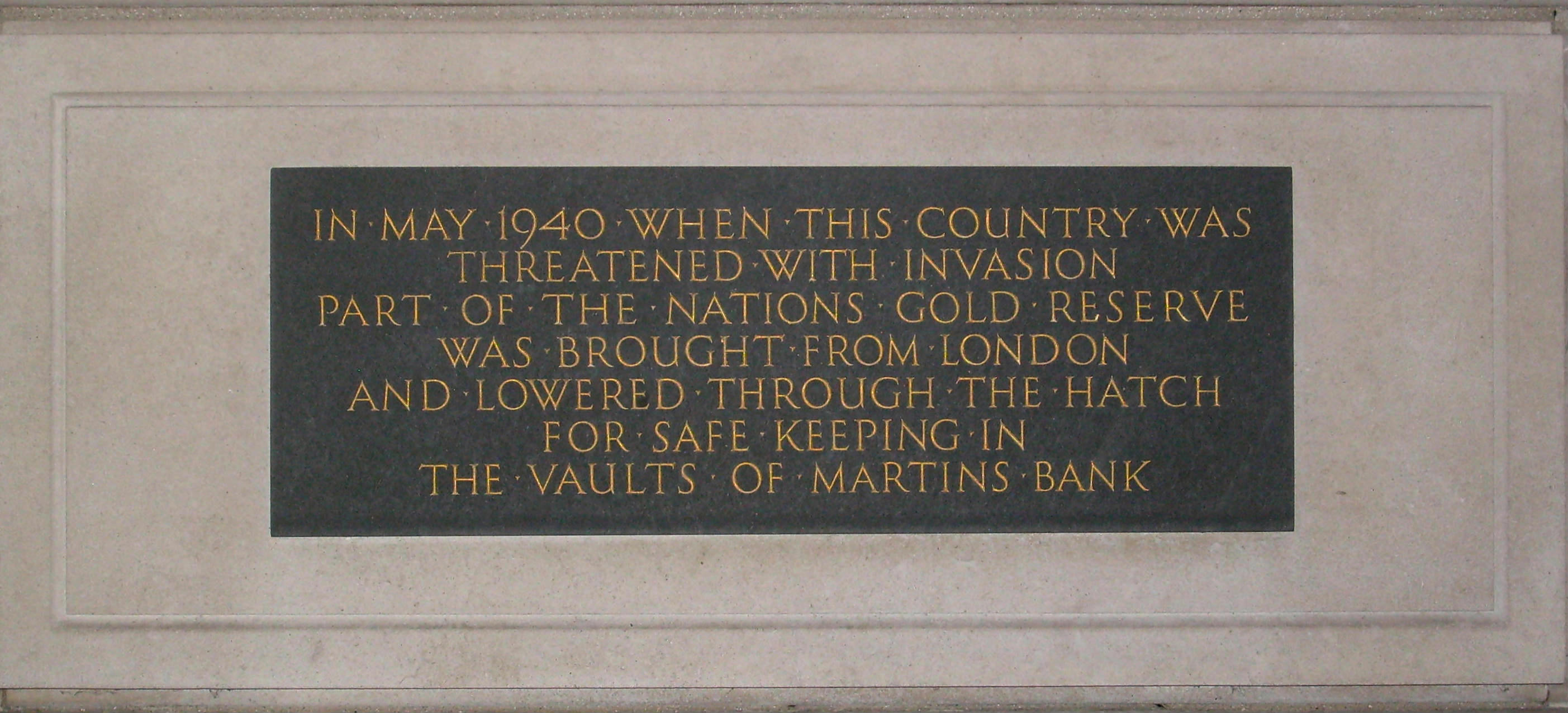
Martins Bank was a London private bank, trading for much of its time under the symbol of “The Grasshopper”, that could trace its origins back to the London goldsmiths. Martins agreed to its acquisition by the Bank of Liverpool in 1918. The Bank of Liverpool wanted Martins to give it a London presence and a seat on the London Bankers' Clearing House; the Martins name was retained in the title of the enlarged bank which was known as The Bank of Liverpool and Martin's Limited. The title was shortened to Martins Bank Limited (without an apostrophe) in 1928 at the insistence of the directors of the Lancashire and Yorkshire Bank when it was bought by the Bank of Liverpool and Martins. The head office and managerial control remained firmly in Liverpool, cementing Martins' place as the only English national bank to have its head office outside London. History The history of Martins Bank is intertwined with the Grasshopper, the sign under which the Bank traded and was known in its ear ... [...More Info...] [...Related Items...] OR: [Wikipedia] [Google] [Baidu] |
Kemerton Court
Kemerton Court is the principal manor house of the village of Kemerton, near Tewkesbury in Gloucestershire. The house is built of local Cotswold stone, dating from the late 16th century onwards. In the early 18th century a 9-bay baroque façade of some elegance was added by the squire, John Parsons III (1649–1722). Thomas White of Worcester and the Smiths of Warwick have been variously suggested as the architects. It is a Grade II* listed building. Kemerton Court is set in parkland and is surrounded by a farming estate of around . It is owned by conservationist Adrian Darby, president of Plantlife and former chairman of the RSPB. He is married to Lady Meriel Darby, daughter of the former Prime Minister, Alec Douglas-Home, 14th Earl of Home, who was a frequent visitor to the Court. History The manor was granted by King Henry III to Sir Robert de Musgrove (or Mucegros) in 1240. Since that time, apart from the brief period 1918–1949, it has remained in the possess ... [...More Info...] [...Related Items...] OR: [Wikipedia] [Google] [Baidu] |
Roman Britain
Roman Britain was the period in classical antiquity when large parts of the island of Great Britain were under occupation by the Roman Empire. The occupation lasted from AD 43 to AD 410. During that time, the territory conquered was raised to the status of a Roman province. Julius Caesar invaded Britain in 55 and 54 BC as part of his Gallic Wars. According to Caesar, the Britons had been overrun or culturally assimilated by other Celtic tribes during the British Iron Age and had been aiding Caesar's enemies. He received tribute, installed the friendly king Mandubracius over the Trinovantes, and returned to Gaul. Planned invasions under Augustus were called off in 34, 27, and 25 BC. In 40 AD, Caligula assembled 200,000 men at the Channel on the continent, only to have them gather seashells ('' musculi'') according to Suetonius, perhaps as a symbolic gesture to proclaim Caligula's victory over the sea. Three years later, Claudius directed f ... [...More Info...] [...Related Items...] OR: [Wikipedia] [Google] [Baidu] |

.jpg)


