|
Noel Benson
William Noel Benson Royal Society, FRS Royal Geographical Society, FRGS (26 December 1885 – 20 August 1957) was an English-born research geologist and academic active first in Australia and then New Zealand. After studying geology at the University of Sydney, Benson worked temporarily at the University of Adelaide before returning to Sydney as a demonstrator. After winning an 1851 Exhibition Science Scholarship in 1910 he left Sydney to study at the University of Cambridge, where he worked until 1913. He returned to Sydney in 1914 as the Macleay Fellow in Geology, leaving in 1917 to become Chair of the Geology Department at the University of Otago, where for many years he was the only lecturer. During his lifetime he published over 100 papers and won several awards, including the Clarke Medal and the Lyell Medal. He died on 20 August 1957 following his retirement from academia in 1951. Early life and education Benson was born on 26 December 1885 in Anerley, London, England, t ... [...More Info...] [...Related Items...] OR: [Wikipedia] [Google] [Baidu] |
Anerley
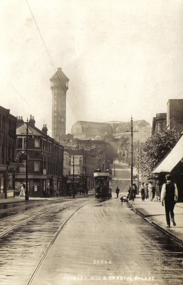
Anerley () is suburb of south east London, England, within the London Borough of Bromley. It is located south south-east of Charing Cross, to the south of Upper Norwood, west of Penge, north of Elmers End and east of South Norwood. The northern edge of Anerley contains part of the area commonly known as Crystal Palace, and the site of the ancient Vicar's Oak where the London boroughs of Bromley, Croydon, Lambeth and Southwark meet, with Lewisham 800 yards (740m) away. History Origin and development Anerley began as a "new town" within the ancient hamlet of Penge. Prior to enclosure in 1827, what would later become known as Anerley, was an unoccupied part of Penge Common, that did not fully develop until the 1850s following the relocation of the Crystal Palace to Penge Place at the top of Sydenham Hill. The Penge Inclosure Act 1827 ( 7 & 8 Geo. 4. c. ''35'' ) ''to divide and inclose a parcel of waste land called Penge Common'' stipulated that a 50 feet (15 metres) wide, ... [...More Info...] [...Related Items...] OR: [Wikipedia] [Google] [Baidu] |
Friends' School, Hobart
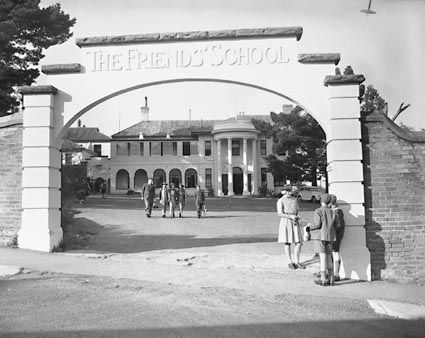
The Friends' School, Hobart is an independent co-educational Quaker day and boarding school located in North Hobart, a suburb of Hobart, Tasmania, Australia. Founded in 1887 by Quakers, the school caters for approximately 1330 students from pre-kindergarten to Year 12, including 47 boarders from Years 7 to 12. It is the largest Quaker school in the world. Friends' is affiliated with the Association of Independent Schools of Tasmania (AIST), the Junior School Heads Association of Australia (JSHAA), the Association of Heads of Independent Schools of Australia (AHISA), the Australian Boarding Schools' Association (ABSA), and is a member of the Sports Association of Tasmanian Independent Schools (SATIS). History The Friends' School opened at 60–62 Warwick Street, Hobart (the building still stands) on 31 January 1887 under the control of the Religious Society of Friends (Quakers). It was opened by Samuel Clemes. The initial enrolment of 33 expanded so rapidly that the Schoo ... [...More Info...] [...Related Items...] OR: [Wikipedia] [Google] [Baidu] |
University Of Melbourne
The University of Melbourne (colloquially known as Melbourne University) is a public university, public research university located in Melbourne, Australia. Founded in 1853, it is Australia's second oldest university and the oldest in the state of Victoria (Australia), Victoria. Its Parkville Campus (University of Melbourne), main campus is located in Parkville, Victoria, Parkville, an inner suburb north of Melbourne central business district, Melbourne's central business district, with several other campuses located across the state of Victoria (Australia), Victoria. Incorporated in the 19th century by the State of Victoria, colony of Victoria, the University of Melbourne is one of Australia's six sandstone universities and a member of the Group of Eight (Australian universities), Group of Eight, Universitas 21, Washington University in St. Louis, Washington University's McDonnell International Scholars Academy, and the Association of Pacific Rim Universities. Since 1872, many ... [...More Info...] [...Related Items...] OR: [Wikipedia] [Google] [Baidu] |
Sedgwick Museum Of Earth Sciences
The Sedgwick Museum of Earth Sciences, is the geology museum of the University of Cambridge. It is part of the Department of Earth Sciences and is located on the university's Downing Site in Downing Street, central Cambridge, England. The Sedgwick Museum is the oldest of the eight museums which make up the University of Cambridge Museums consortium. History Construction and opening Dr John Woodward collected and catalogued over 35 years nearly 10,000 specimens in five walnut cabinets, two of which he bequeathed to the university in his will. The university later purchased another two, and the fifth was added in the 1840s. The cabinets are still in use today. He also left funds to establish the position of the Woodwardian Professor of Geology. Adam Sedgwick began the process of expanding the collection, and purchased several ichthyosaur skeletons from Mary Anning. He persuaded the university to set aside space in the Cockerill Building, but by the time he died, the collect ... [...More Info...] [...Related Items...] OR: [Wikipedia] [Google] [Baidu] |
Thomas George Bonney
Thomas George Bonney (27 July 1833 – 10 December 1923) was an English geologist, president of the Geological Society of London. Career Bonney was born in Rugeley, Staffordshire, England, the eldest son of the Reverend Thomas Bonney, headmaster of Rugeley Grammar School. His uncle was the Australian explorer Charles Bonney, and one of his brothers, Frederic Bonney, is remembered for his photography and ethnology in Australia. Thomas was educated at Uppingham School and St John's College, Cambridge, where he graduated as 12th wrangler in 1856, and was ordained in the following year. From 1856 to 1861 he was mathematical master at Westminster School, and he pursued geology only as a recreational activity, mainly in Alpine regions. In 1868 he was appointed tutor at St John's College, Cambridge and lecturer in geology. His attention was specially directed to the study of the igneous and metamorphic rocks in Alpine regions and in various parts of England (e.g.: the Lizard in ... [...More Info...] [...Related Items...] OR: [Wikipedia] [Google] [Baidu] |
Alfred Harker
Alfred Harker Fellow of the Royal Society, FRS (19 February 1859 – 28 July 1939) was an English geologist who specialised in petrology and interpretive petrography. He was lecturer in petrology at the University of Cambridge for many years, and carried out field mapping for the Geological Survey of Scotland and geological studies of western Scotland and the Isle of Skye. He and other British geologists pioneered the use of thin sections and the petrographic microscope in interpretive petrology. Education and career Harker's father was the Yorkshire corn merchant Portas Hewart Harker, his mother Ellen Mary Harker. He attended Hull College, Hull and East Riding College, and the private Clewer House School (Windsor, Berkshire, Windsor) before enrolling as an undergraduate at St John's College, Cambridge, St. John's College (Cambridge) from where he graduated with an Master's degree, M.A. on 18 January 1882. Whilst at Cambridge he was an early member of the Sedgwick Club. In 1884 ... [...More Info...] [...Related Items...] OR: [Wikipedia] [Google] [Baidu] |
John Edward Marr
John Edward Marr FGS FRS (14 June 1857 – 1 October 1933) was a British geologist. After studying at Lancaster Royal Grammar School, he matriculated to St John's College, Cambridge, graduating with First Class Honours in 1878. Following undergraduate work in the Lake District, he travelled to Bohemia to investigate the fossil collection of Joachim Barrande, where his work won him the Sedgwick Prize in 1882. In 1886, Marr became lecturer at the University of Cambridge Department of Geology, a position he held for 32 years until he succeeded Thomas McKenny Hughes as Woodwardian Professor of Geology in 1917. Early life and education Marr was born in Poulton-le-Sands on 14 June 1857 to John Marr, a retired silk merchant, and his wife Mary Simpson. After the family stayed in Caernarfon in 1863, Marr became interested in geology, having discovered a fossil which was named after him. From 1867 to 1875 he studied at the Lancaster Royal Grammar School, where he met R. H. Tiddeman, ... [...More Info...] [...Related Items...] OR: [Wikipedia] [Google] [Baidu] |
Mount Lofty Ranges
The Mount Lofty Ranges are a range of mountains in the Australian state of South Australia which for a small part of its length borders the east of Adelaide. The part of the range in the vicinity of Adelaide is called the Adelaide Hills and defines the eastern border of the Adelaide Plains. Location and description The Mount Lofty Ranges stretch from the southernmost point of the Fleurieu Peninsula at Cape Jervis northwards for over before petering out north of Peterborough. In the vicinity of Adelaide, they separate the Adelaide Plains from the extensive plains that surround the Murray River and stretch eastwards to Victoria. The Heysen Trail traverses almost the entire length of the ranges, crossing westwards to the Flinders Ranges near Hallett. The mountains have a Mediterranean climate with moderate rainfall brought by south-westerly winds, hot summers and cool winters. The southern ranges are wetter (with of rain per year) than the northern ranges (). Southern r ... [...More Info...] [...Related Items...] OR: [Wikipedia] [Google] [Baidu] |
Geomorphology
Geomorphology () is the scientific study of the origin and evolution of topographic and bathymetric features generated by physical, chemical or biological processes operating at or near Earth's surface. Geomorphologists seek to understand why landscapes look the way they do, to understand landform and terrain history and dynamics and to predict changes through a combination of field observations, physical experiments and numerical modeling. Geomorphologists work within disciplines such as physical geography, geology, geodesy, engineering geology, archaeology, climatology, and geotechnical engineering. This broad base of interests contributes to many research styles and interests within the field. Overview Earth's surface is modified by a combination of surface processes that shape landscapes, and geologic processes that cause tectonic uplift and subsidence, and shape the coastal geography. Surface processes comprise the action of water, wind, ice, wildfire, and lif ... [...More Info...] [...Related Items...] OR: [Wikipedia] [Google] [Baidu] |
Barossa Range
The Barossa Range (Kaurna: ''Yampoori'') is a mountain range located in the Australian state of South Australia. Location The range is a part of the southern Mount Lofty Ranges and the western slopes primarily fall into the Barossa Valley. As such, the range is the main source for the North Para River and its tributary Jacob's Creek. The highest point of the range is Mount Kaiser Stuhl with an elevation of and forms part of the Kaiserstuhl Conservation Park. Mengler Hill, another notable peak within the range, lies on the road route from Tanunda to Angaston. Naming The range was named by Colonel William Light in 1837 after Barrosa Hill (Cerro de Puerco) in the modern municipality of Chiclana de la Frontera, Spain, to which it he thought it similar. The Spanish location was the site of the Battle of Barrosa and was won by Light's friend Lord Lynedoch (Lt. Gen. Sir Thomas Graham) in 1811. The word ''barrosa'' (mis-spelt in the naming of the valley, two 'r' and one 's ... [...More Info...] [...Related Items...] OR: [Wikipedia] [Google] [Baidu] |
Cambrian
The Cambrian ( ) is the first geological period of the Paleozoic Era, and the Phanerozoic Eon. The Cambrian lasted 51.95 million years from the end of the preceding Ediacaran period 538.8 Ma (million years ago) to the beginning of the Ordovician Period 486.85 Ma. Most of the continents lay in the southern hemisphere surrounded by the vast Panthalassa Ocean. The assembly of Gondwana during the Ediacaran and early Cambrian led to the development of new convergent plate boundaries and continental-margin arc magmatism along its margins that helped drive up global temperatures. Laurentia lay across the equator, separated from Gondwana by the opening Iapetus Ocean. The Cambrian marked a profound change in life on Earth; prior to the Period, the majority of living organisms were small, unicellular and poorly preserved. Complex, multicellular organisms gradually became more common during the Ediacaran, but it was not until the Cambrian that fossil diversity seems to rapidly ... [...More Info...] [...Related Items...] OR: [Wikipedia] [Google] [Baidu] |
Pre-Cambrian
The Precambrian ( ; or pre-Cambrian, sometimes abbreviated pC, or Cryptozoic) is the earliest part of Earth's history, set before the current Phanerozoic Eon. The Precambrian is so named because it preceded the Cambrian, the first period of the Phanerozoic Eon, which is named after Cambria, the Latinized name for Wales, where rocks from this age were first studied. The Precambrian accounts for 88% of the Earth's geologic time. The Precambrian is an informal unit of geologic time, subdivided into three eons (Hadean, Archean, Proterozoic) of the geologic time scale. It spans from the formation of Earth about 4.6 billion years ago ( Ga) to the beginning of the Cambrian Period, about million years ago ( Ma), when hard-shelled creatures first appeared in abundance. Overview Relatively little is known about the Precambrian, despite it making up roughly seven-eighths of the Earth's history, and what is known has largely been discovered from the 1960s onwards. The Precambrian fossi ... [...More Info...] [...Related Items...] OR: [Wikipedia] [Google] [Baidu] |


