|
List Of Places With Columnar Jointed Volcanics
Columnar jointed volcanic rocks exist in many places on Earth. Perhaps the most famous basalt lava flow in the world is the Giant's Causeway in Northern Ireland, in which the vertical joints form polygonal columns and give the impression of having been artificially constructed. Notable columnar jointed volcanics Africa Ikom Columnar Basalt in Cross River State, Nigeria * Bugarama in Rusizi, Rwanda Columnar jointing in Rusizi district, Nzahaha Sector. This may have formed from contractional cooling of basaltic lavas. * "Organ Pipes" near Twyfelfontein, Namibia * Numan, Nigeria * Seliana, Tunisia * Rochester Falls, Mauritius * Foreke Quarry, Foreke Dachang, Cameroon South Asia ; India In India, columnars are found in several places across the volcanic traps such as 6.5 crore or 65 million years ago (Mya) old deccan traps in South India and 14.5 crore or 145 mya old Rajmahal Traps in Eastern India. * Karnataka ** St. Mary's Island columnars near Malpe in Udupi district ... [...More Info...] [...Related Items...] OR: [Wikipedia] [Google] [Baidu] |
East India
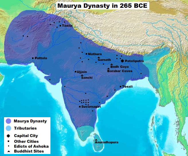
East India is a region of India consisting of the Indian states of Bihar, Jharkhand, Odisha and West Bengal and also the union territory of the Andaman and Nicobar Islands. The region roughly corresponds to the historical region of Magadha from which it inherits its various Eastern Indo-Aryan languages. The states of Bihar and West Bengal lie on the Indo-Gangetic plain. Jharkhand is situated on the Chota Nagpur Plateau. Odisha lies on the Eastern Ghats and the Deccan Plateau. West Bengal's capital Kolkata is the largest city of this region. The Kolkata Metropolitan Area is the country's third largest. The region is bounded by Bhutan, Nepal and the state of Sikkim in the north, the states of Uttar Pradesh and Chhattisgarh on the west, the state of Andhra Pradesh in the south and the country of Bangladesh in the east. It is also bounded by the Bay of Bengal in the south-east. It is connected to the Seven Sister States of Northeast India by the narrow Siliguri Corrido ... [...More Info...] [...Related Items...] OR: [Wikipedia] [Google] [Baidu] |
Andheri
Andheri ( �n̪d̪ʱeɾiː is a locality in the western part of the city of Mumbai in India. Udayanagari, the name of a hill near the Mahakali caves, inspired the name Andheri. On the former islet of Versova, also known as Vasave, there was another cluster of native East Indians. Andheri east and west are key areas in Mumbai, with several film studios and TV news channels. high-profile police cases. Andheri west is covered by a fire complaint filed at the Oshiwara police station. MIDC, Andheri has a jewelry production unit (east). Government For administrative purposes, the area is separated into Andheri West and Andheri East. Andheri West comes under K/W ward of the Brihanmumbai Municipal Corporation while Andheri East comes under the K/E ward of the same. Transportation The Andheri railway station is among the busiest railway stations in the city The expansion of the Mumbai Metro in the Versova-Andheri-Ghatkopar corridor is a part of the government's master transportati ... [...More Info...] [...Related Items...] OR: [Wikipedia] [Google] [Baidu] |
Gilbert Hill
Gilbert Hill is a monolith column of black basalt rock at Andheri, in Mumbai, India. The rock has a sheer vertical face and was formed when molten lava was squeezed out of the Earth's clefts during the Mesozoic Era about 66 million years ago. During that era, molten lava had spread around most of the Indian states of Maharashtra, Gujarat and Madhya Pradesh, covering an area of . The volcanic eruptions were also responsible for the destruction of plant and animal life during that era. According to experts, this rare geological phenomenon was the remnant of a ridge and had clusters of vertical columns in nearby Jogeshwari which were quarried off two decades ago. These vertical columns are similar to the Devils Tower National Monument in Wyoming, and the Devils Postpile National Monument in eastern California, USA. Gilbert Hill was declared a National Park in 1952 by the Central Government under the Forest Act. In 2007, after years of lobbying by geologists, the hill was declar ... [...More Info...] [...Related Items...] OR: [Wikipedia] [Google] [Baidu] |
Kolhapur District
Kolhapur district (Marathi pronunciation: olʱaːpuɾ is a district in the Maharashtra state of India. The city of Kolhapur is its district headquarter. It is situated near Panchaganga river. It is bordered by the Sangli district to the North, by Ratnagiri district, Sindhudurg to the West and by Karnataka state to the East. Officer Members of Parliament * Sanjay Mandlik ( BSS) *Dhairyasheel Sambhajirao Mane ( BSS) Guardian Minister list of Guardian Minister District Magistrate/Collector list of District Magistrate / Collector History Kolhapur was a princely state during British rule of India. Shahu Maharaj ruled it from 1894 to 1922. He worked for the development of the state. It was a hub for Marathi film industry. It was known as 'Chitranagari'. It is now known as Bhalji Pendharkar Chitranagari. Geography Kolhapur district have Bauxite mineral resources in Sahyadri mountains. Ghatprabha, ''Tamraparni'', Dudhganga, Krushna, Bhogawati, Warna, ''Kasa ... [...More Info...] [...Related Items...] OR: [Wikipedia] [Google] [Baidu] |
Panhala
Panhala (Pronunciation: ənʱaːɭa is a city and a Hill station Municipal Council (3177 feet above sea level) 18 km northwest of Kolhapur, in Kolhapur district in the Indian state of Maharashtra. Panhala is the smallest city in Maharashtra and being a Municipal Council the city is developing rapidly. The city sprawls in the Panhala fort commands a panoramic view of the valley below. The main historical attraction here is the Panhala fort. There are many places of interest, each with its share of haunting anecdotes. History The history of Panhala is closely linked with the history of the Maratha empire, and with its founder, Shivaji. Panhala is the only fort where Shivaji spent more than 500 days, other than his childhood homes. It was Maratha State capital until 1782 and in 1827 it became part of the British Empire. This imposing fort, 20 km northwest of Kolhapur, is built on an outlying spur of the Sahyadris, rising more than 400 m above plain, and is the lar ... [...More Info...] [...Related Items...] OR: [Wikipedia] [Google] [Baidu] |
Maharashtra
Maharashtra (; , abbr. MH or Maha) is a state in the western peninsular region of India occupying a substantial portion of the Deccan Plateau. Maharashtra is the second-most populous state in India and the second-most populous country subdivision globally. It was formed on 1 May 1960 by splitting the bilingual Bombay State, which had existed since 1956, into majority Marathi-speaking Maharashtra and Gujarati-speaking Gujarat. Maharashtra is home to the Marathi people, the predominant ethno-linguistic group, who speak the Marathi language, the official language of the state. The state is divided into 6 divisions and 36 districts, with the state capital being Mumbai, the most populous urban area in India, and Nagpur serving as the winter capital, which also hosts the winter session of the state legislature. Godavari and Krishna are the two major rivers in the state. Forests cover 16.47 per cent of the state's geographical area. Out of the total cultivable land in the ... [...More Info...] [...Related Items...] OR: [Wikipedia] [Google] [Baidu] |
Narsinghpur
Narsinghpur is a city in Madhya Pradesh in central India. It comes under Jabalpur division. Narsinghpur has a large temple dedicated to Lord Narsingh As of 2001, Narsinghpur is the most literate district of the state. History Prehistory The earliest signs of human life in Narsinghpur were found recently in the caves of Vinaiki village which lies on the banks of Shakkar river (tributary of Narmada), in the hinterlands of Kareli Forest Zone (a part of Satpura reserve) in Narsinghpur. Most of the villagers are Gonds and they knew about the paintings for a long time. Locals call the rock paintings found in their village by the name 'Putra Putariya' (पुतरा पुतरिया).The actual age of the rock paintings is not yet determined. Analysis by the Department of Archaeology is awaited. The axe, bow and arrows, and swords can be seen in the pictures. The rock paintings depict humans riding and playing with horses and elephants. Humans are also seen hunting ani ... [...More Info...] [...Related Items...] OR: [Wikipedia] [Google] [Baidu] |
Chhindwara
, other_name = Corn city , nickname = , settlement_type = City , image_skyline = , image_alt = , image_caption = , pushpin_map = India Madhya Pradesh#India3 , pushpin_label_position = right , pushpin_map_alt = , pushpin_map_caption = Location in Madhya Pradesh, India , coordinates = , subdivision_type = Country , subdivision_name = , subdivision_type1 = State , subdivision_name1 = Madhya Pradesh , subdivision_type2 = District , subdivision_name2 = Chhindwara , established_title = , established_date = , founder = , named_for = , government_type = Mayor–Council , governing_body ... [...More Info...] [...Related Items...] OR: [Wikipedia] [Google] [Baidu] |
Madhya Pradesh
Madhya Pradesh (, ; meaning 'central province') is a state in central India. Its capital is Bhopal, and the largest city is Indore, with Jabalpur, Ujjain, Gwalior, Sagar, and Rewa being the other major cities. Madhya Pradesh is the second largest Indian state by area and the fifth largest state by population with over 72 million residents. It borders the states of Uttar Pradesh to the northeast, Chhattisgarh to the east, Maharashtra to the south, Gujarat to the west, and Rajasthan to the northwest. The area covered by the present-day Madhya Pradesh includes the area of the ancient Avanti Mahajanapada, whose capital Ujjain (also known as Avantika) arose as a major city during the second wave of Indian urbanisation in the sixth century BCE. Subsequently, the region was ruled by the major dynasties of India. The Maratha Empire dominated the majority of the 18th century. After the Anglo-Maratha Wars in the 19th century, the region was divided into several princel ... [...More Info...] [...Related Items...] OR: [Wikipedia] [Google] [Baidu] |
Udupi District
Udupi district (also Udipi or Odipu in Tulu language) is an administrative subdivision in the Karnataka state of India, with the district headquarters in the city of Udupi. It is situated in the Canara coastal region, there are seven taluks, 233 villages and 21 towns in Udupi district. The three northern tehsils of Udupi, Kundapur and Karkala, were partitioned from Dakshina Kannada district (South Canara) to form Udupi district on 25 August 1997. Moodabidri was officially declared as new tehsil (taluk), separated from Karkala with effect from 11 January 2018. In February 2018, the district was split to into 3 more taluks, with Byndoor being carved out of Kundapur taluk and the Udupi taluk being split into three parts. Along with the initial Udupi taluk, Kapu, Brahmavar and Hebri were created. Dinakar Babu and Sheela K Shetty of the Bharatiya Janata Party (BJP) are the current president (Sarpanch) and vice-president of the Udupi Zilla Panchayat, respectively, after t ... [...More Info...] [...Related Items...] OR: [Wikipedia] [Google] [Baidu] |


_male.jpg)