|
India–Pakistan Border
The India–Pakistan border is the international boundary that separates the nations of the Republic of India and the Islamic Republic of Pakistan. At its northern end is the Line of Control, which separates Indian-administered Jammu & Kashmir from Pakistani- administered Kashmir; and at its southern end is Sir Creek, a tidal estuary in the Rann of Kutch between the Indian state of Gujarat and the Pakistani province of Sindh. Arising from the partition of India in 1947, the border covers the provincial boundaries of Gujarat and Rajasthan with Sindh, and the Radcliffe Line between the partitions of Punjab. It traverses a variety of terrain in the northwestern region of the subcontinent, ranging from major urban areas to inhospitable deserts. Since the beginning of the India–Pakistan conflict shortly after the two countries' conjoined independence, it has been the site of numerous cross-border military standoffs and full-scale wars. The border's total length is accordin ... [...More Info...] [...Related Items...] OR: [Wikipedia] [Google] [Baidu] |
Rann Of Kutch
The Rann of Kutch is a large area of salt marshes that span the border between India and Pakistan. It is located mostly in the Kutch district of the Indian state of Gujarat, with a minor portion extending into the Sindh province of Pakistan. It is divided into the Great Rann of Kutch, Great Rann and Little Rann of Kutch, Little Rann. It used to be a part of the Arabian Sea, but it then dried up, leaving behind the salt, which formed the Rann of Kutch. The Luni River, Luni flowed into the Rann of Kutch, but when the Rann dried up, the Luni was left behind, which explains why the Luni does not flow into the Arabian Sea today. Geography The Rann of Kutch is located mostly in the Indian state of Gujarat, specifically Kutch district, for which it is named. Some parts extend into the Pakistani province of Sindh. The word ''Rann or Rinn'' means "desert" in Sindhi and Gujarati. The Rann of Kutch covers around 26,000 square kilometres (10,000 square miles). The Great Rann of Kutch is ... [...More Info...] [...Related Items...] OR: [Wikipedia] [Google] [Baidu] |
Siachen Conflict
The Siachen conflict, sometimes referred to as the Siachen Glacier conflict or the Siachen War, was a military conflict Indo-Pakistani wars and conflicts, between India and Pakistan over the disputed Siachen Glacier region in Kashmir. The conflict was started in 1984 by India's successful capture of the Siachen Glacier as part of Operation Meghdoot, and continued with Operation Rajiv in 1987. India took control of the Siachen Glacier and its tributary glaciers, as well as all the main passes and heights of the Saltoro Mountains, Saltoro Ridge immediately west of the glacier, including Sia La, Bilafond La, and Gyong La. Pakistan controls the glacial valleys immediately west of the Saltoro Ridge. A cease-fire went into effect in 2003, but both sides maintain a heavy military presence in the area. The conflict has resulted in thousands of deaths, mostly due to natural hazards. External commentators have characterized it as pointless, given the perceived uselessness of the territor ... [...More Info...] [...Related Items...] OR: [Wikipedia] [Google] [Baidu] |
Actual Ground Position Line
The Actual Ground Position Line (AGPL) divides current positions of Indian and Pakistani military posts and troops along the entire long frontline in the disputed region of Siachen Glacier. AGPL generally runs along the Saltoro Mountains range, beginning from the northernmost point of the ( LOC) at Point NJ 9842 and ending in the north on the Indira Ridge at the India-China-Pakistan LAC tripoint near Sia Kangri about northwest of Indira Col West, with peaks in excess of and temperatures ranging to around . India gained control of of disputed territory in 1984 because of its military operations in Siachen. A cease-fire was announced in 2003. India has at least 108 forward military outposts and artillery observation posts in this area where temperature goes down to during winters with icy 300 km/h () blizzards. Bana Top () is the highest post and requires an trek that takes up to 20 days for troops to reach. Pahalwan Post (), and Indira Col (), are other high posts ... [...More Info...] [...Related Items...] OR: [Wikipedia] [Google] [Baidu] |
Kashmir Region (working Boundary)
Kashmir ( or ) is the northernmost geographical region of the Indian subcontinent. Until the mid-19th century, the term ''Kashmir'' denoted only the Kashmir Valley between the Great Himalayas and the Pir Panjal Range. The term has since also come to encompass a larger area that includes the Indian-administered territories of Jammu and Kashmir and Ladakh, the Pakistani-administered territories of Azad Kashmir and Gilgit-Baltistan, and the Chinese-administered territories of Aksai Chin and the Trans-Karakoram Tract. Quote: "Kashmir, region of the northwestern Indian subcontinent. It is bounded by the Uygur Autonomous Region of Xinjiang to the northeast and the Tibet Autonomous Region to the east (both parts of China), by the Indian states of Himachal Pradesh and Punjab to the south, by Pakistan to the west, and by Afghanistan to the northwest. The northern and western portions are administered by Pakistan and comprise three areas: Azad Kashmir, Gilgit, and Baltistan, ... The ... [...More Info...] [...Related Items...] OR: [Wikipedia] [Google] [Baidu] |
Floodlight
A floodlight is a broad-beamed, high-intensity artificial light. It can provide functional area lighting for travel-ways, parking, entrances, work areas, and sporting venues to enable visibility adequate for safe task performance, ornamental lighting for advertising, façades, monuments, or support perimeter security. Floodlights are often used to illuminate outdoor playing fields while an outdoor sports event is being held during low-light conditions. More focused kinds are often used as a stage lighting instrument in live performances such as concerts and plays. Floodlights may also be used to add effects to buildings at night, called architectural illumination. Types The most common type of floodlight was the metal-halide lamp, which emits a bright white light (typically 75–100 lumens/Watt). Sodium-vapor lamps are also commonly used for sporting events, as they have a very high lumen to watt ratio (typically 80–140 lumens/Watt), making them a cost-effecti ... [...More Info...] [...Related Items...] OR: [Wikipedia] [Google] [Baidu] |
Foreign Policy
Foreign policy, also known as external policy, is the set of strategies and actions a State (polity), state employs in its interactions with other states, unions, and international entities. It encompasses a wide range of objectives, including defense and security, economic benefits, and humanitarian assistance. The formulation of foreign policy is influenced by various factors such as domestic considerations, the behavior of other states, and geopolitical strategies. Historically, the practice of foreign policy has evolved from managing short-term crises to addressing long-term international relations, with diplomatic corps playing a crucial role in its development. The objectives of foreign policy are diverse and interconnected, contributing to a comprehensive approach for each state. Defense and security are often primary goals, with states forming military alliances and employing soft power to combat threats. Economic interests, including trade agreements and foreign aid ... [...More Info...] [...Related Items...] OR: [Wikipedia] [Google] [Baidu] |
Indo-Pakistani Wars And Conflicts
Since the partition of British India in 1947 and subsequent creation of the dominions of India and Pakistan, the two countries have been involved in a number of wars, conflicts, and military standoffs. A long-running dispute over Kashmir and cross-border terrorism have been the predominant cause of conflict between the two states, with the exception of the Indo-Pakistani War of 1971, which occurred as a direct result of hostilities stemming from the Bangladesh Liberation War in erstwhile East Pakistan (now Bangladesh). Background The Partition of India came in 1947 with the sudden grant of independence. It was the intention of those who wished for a Muslim state to have a clean partition between independent and equal "Pakistan" and "Hindustan" once independence came.* Nearly one third of the Muslim population of India remained in the new India. Inter-communal violence between Hindus, Sikhs and Muslims resulted in between 200,000 and 2 million casualties leaving 14 mi ... [...More Info...] [...Related Items...] OR: [Wikipedia] [Google] [Baidu] |
The Subcontinent
The Indian subcontinent is a physiographic region of Asia below the Himalayas which projects into the Indian Ocean between the Bay of Bengal to the east and the Arabian Sea to the west. It is now divided between Bangladesh, India, and Pakistan. (subscription required) Although the terms "Indian subcontinent" and "South Asia" are often also used interchangeably to denote a wider region which includes, in addition, Bhutan, the Maldives, Nepal and Sri Lanka, the "Indian subcontinent" is more of a geophysical term, whereas "South Asia" is more geopolitical. "South Asia" frequently also includes Afghanistan, which is not considered part of the subcontinent even in extended usage.Jim Norwine & Alfonso González, ''The Third World: states of mind and being'', pages 209, Taylor & Francis, 1988, Quote: ""The term "South Asia" also signifies the Indian Subcontinent""Raj S. Bhopal, ''Ethnicity, race, and health in multicultural societies'', pages 33, Oxford University Press, 2007, ; Q ... [...More Info...] [...Related Items...] OR: [Wikipedia] [Google] [Baidu] |
Northwestern Indian Subcontinent
Northwest India is a loosely defined region of India. In modern-day, it consists of north-western states of the Republic of India. In historical contexts, it refers to the northwestern Indian subcontinent. In contemporary definition, it generally includes the states of Haryana, Himachal Pradesh, Punjab, Rajasthan Uttarakhand, and often Uttar Pradesh, along with the union territories of Chandigarh, Jammu and Kashmir, Ladakh, and the National Capital Territory of Delhi. Gujarat is occasionally included as well.A Brief History of India Emiliano Unzer "In cultural and religious terms, India was home to Hinduism, Buddhism, Jainism, Sikhism among others, and sheltered the Zoroastrians from the Persian lands to the west, as ... [...More Info...] [...Related Items...] OR: [Wikipedia] [Google] [Baidu] |
Radcliffe Line
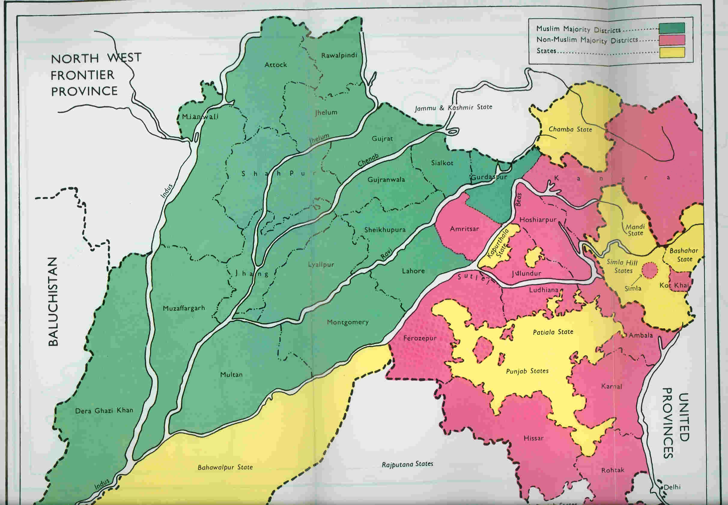
The Radcliffe Line was the boundary demarcated by the two boundary commissions for the provinces of Punjab Province (British India), Punjab and Bengal Presidency, Bengal during the Partition of India. It is named after Cyril Radcliffe, 1st Viscount Radcliffe, Cyril Radcliffe, who, as the joint chairman of the two boundary commissions, had the ultimate responsibility to equitably divide of territory with 88 million people. The term "Radcliffe Line" is also sometimes used for the entire boundary between India and Pakistan. However, outside of Punjab and Bengal, the boundary is made of existing provincial boundaries and had nothing to do with the Radcliffe commissions. The demarcation line was published on 17 August 1947, two days after the independence of Pakistan and India. Today, the Punjab part of the line is part of the India–Pakistan border while the Bengal part of the line serves as the Bangladesh–India border. Background Events leading up to the Radcliffe Boundary Co ... [...More Info...] [...Related Items...] OR: [Wikipedia] [Google] [Baidu] |
Rajasthan
Rajasthan (; Literal translation, lit. 'Land of Kings') is a States and union territories of India, state in northwestern India. It covers or 10.4 per cent of India's total geographical area. It is the List of states and union territories of India by area, largest Indian state by area and the List of states and union territories of India by population, seventh largest by population. It is on India's northwestern side, where it comprises most of the wide and inhospitable Thar Desert (also known as the Great Indian Desert) and shares a border with the Pakistani provinces of Punjab, Pakistan, Punjab to the northwest and Sindh to the west, along the Sutlej-Indus River valley. It is bordered by five other Indian states: Punjab, India, Punjab to the north; Haryana and Uttar Pradesh to the northeast; Madhya Pradesh to the southeast; and Gujarat to the southwest. Its geographical location is 23°3' to 30°12' North latitude and 69°30' to 78°17' East longitude, with the Tropic of Can ... [...More Info...] [...Related Items...] OR: [Wikipedia] [Google] [Baidu] |


