|
Geoglyphs
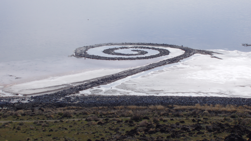
A geoglyph is a large design or motif – generally longer than – produced on the ground by durable elements of the landscape, such as stones, stone fragments, gravel, or earth. A positive geoglyph is formed by the arrangement and alignment of materials on the ground in a manner akin to petroforms, while a negative geoglyph is formed by removing part of the natural ground surface to create differently coloured or textured ground in a manner akin to petroglyphs. Geoglyphs are generally a type of land art, and sometimes rock art. A hill figure is created on a slope, so that it can be seen from a distance. Ancient Arguably the most famous geoglyphs are the Nazca lines in Peru. The cultural significance of these geoglyphs for their creators remains unclear, despite many hypotheses. Since the 1970s, numerous geoglyphs have been discovered on deforested land in the Amazon rainforest, Brazil, leading to claims about Pre-Columbian civilizations. Ondemar Dias is accredited wi ... [...More Info...] [...Related Items...] OR: [Wikipedia] [Google] [Baidu] |
Land Art
Land art, variously known as Earth art, environmental art, and Earthworks, is an art movement that emerged in the 1960s and 1970s, largely associated with Great Britain and the United StatesArt in the modern era: A guide to styles, schools, & movements. Abrams, 2002. (U.S. edition of Styles, Schools and Movements, by Amy Dempsey) but that also includes examples from many other countries. As a trend, "land art" expanded the boundaries of traditional art making in the materials used and the siting of the works. The materials used are often the materials of the Earth, including the soil, rocks, vegetation, and water found on-site, and the sites are often distant from population centers. Though sometimes fairly inaccessible, photo documentation is commonly brought back to the urban art gallery.http://www.land-arts.com Land art. Concerns ... [...More Info...] [...Related Items...] OR: [Wikipedia] [Google] [Baidu] |
Acre (state)
Acre () is a state located in the west of the North Region of Brazil and the Amazonia Legal. Located in the westernmost part of the country, at a two-hour time difference from Brasília, Acre is bordered clockwise by the Brazilian states of Amazonas and Rondônia to the north and east, along with an international border with the Bolivian department of Pando to the southeast, and the Peruvian regions of Madre de Dios, Ucayali and Loreto to the south and west. Its capital and largest city is Rio Branco. Other important places include Cruzeiro do Sul, Sena Madureira, Tarauacá and Feijó. The state, which has 0.42% of the Brazilian population, generates 0.2% of the Brazilian GDP. Intense extractive activity in the rubber industry, which reached its height in the early 20th century, attracted Brazilians from many regions to the state. From the mixture of sulista, southeastern Brazil, nordestino, and indigenous traditions arose a diverse cuisine. Fluvial trans ... [...More Info...] [...Related Items...] OR: [Wikipedia] [Google] [Baidu] |
Rock Art
In archaeology, rock arts are human-made markings placed on natural surfaces, typically vertical stone surfaces. A high proportion of surviving historic and prehistoric rock art is found in caves or partly enclosed rock shelters; this type also may be called cave art or parietal art. A global phenomenon, rock art is found in many culturally diverse regions of the world. It has been produced in many contexts throughout human history. In terms of technique, the four main groups are: * cave paintings, * petroglyphs, which are carved or scratched into the rock surface, * sculpted rock reliefs, and * geoglyphs, which are formed on the ground. The oldest known rock art dates from the Upper Palaeolithic period, having been found in Europe, Australia, Asia, and Africa. Anthropologists studying these artworks believe that they likely had magico-religious significance. The archaeological sub-discipline of rock art studies first developed in the late-19th century among Francophone schola ... [...More Info...] [...Related Items...] OR: [Wikipedia] [Google] [Baidu] |
Marree Man
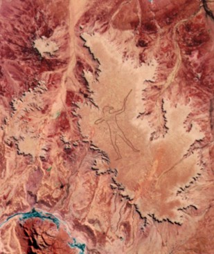
The Marree Man is a modern geoglyph discovered in 1998 in Outback South Australia. It depicts an Aboriginal man hunting with a boomerang or stick. It lies on a plateau at Finniss Springs, west of the township of Marree in central South Australia, approximately 12 km north-west of Callanna. It is just outside the Woomera Prohibited Area. The figure is tall with a perimeter of , extending over an area of about . Discovered fortuitously by a charter pilot in an overflight on 26 June 1998, it is one of the largest geoglyphs in the world, arguably second to the Sajama Lines). Its origin remains a mystery: no one claimed responsibility for its creation and no eye-witness has been found, notwithstanding the scale of the operation required to form the outline on the plateau floor. The description "Stuart's Giant" was used in anonymous faxes sent to media as press releases in July 1998, in a reference to the explorer John McDouall Stuart. Shortly after its discovery, the ... [...More Info...] [...Related Items...] OR: [Wikipedia] [Google] [Baidu] |
Fazenda Colorada
A ''fazenda'' () is a plantation found throughout Brazil during the colonial period (16th - 18th centuries). They were concentrated primarily in the northeastern region, where sugar was produced in the ''engenhos'', expanding during the 19th century in the southeastern region to coffee production. Nowadays ''fazenda'' denotes any kind of farm in Brazilian Portuguese and occasionally in other Portuguese varieties as well. ''Fazendas'' created major export commodities for Brazilian trade, but also led to intensification of slavery in Brazil. Coffee provided a new basis for agricultural expansion in southern Brazil. In the provinces of Rio de Janeiro and then São Paulo, coffee estates, or ''fazendas'', began to spread toward the interior as new lands were opened. By 1850 coffee made up more than 50% of Brazil's exports, which amounted to more than half of the world's coffee production. Along with the expansion of coffee growing came an intensification of slavery as the count ... [...More Info...] [...Related Items...] OR: [Wikipedia] [Google] [Baidu] |
Labyrinth
In Greek mythology, the Labyrinth () is an elaborate, confusing structure designed and built by the legendary artificer Daedalus for King Minos of Crete at Knossos. Its function was to hold the Minotaur, the monster eventually killed by the hero Theseus. Daedalus had so cunningly made the Labyrinth that he could barely escape it after he built it. Although early Cretan coins occasionally exhibit branching (multicursal) patterns, the single-path (unicursal) seven-course "Classical" design without branching or dead ends became associated with the Labyrinth on coins as early as 430 BC, and similar non-branching patterns became widely used as visual representations of the Labyrinth – even though both logic and literary descriptions make it clear that the Minotaur was trapped in a complex branching maze. Even as the designs became more elaborate, visual depictions of the mythological Labyrinth from the Roman era until the Renaissance are almost invariably unicursal. Branching maz ... [...More Info...] [...Related Items...] OR: [Wikipedia] [Google] [Baidu] |
Great Basin Desert
The Great Basin Desert is part of the Great Basin between the Sierra Nevada and the Wasatch Range in the western United States. The desert is a geographical region that largely overlaps the Great Basin shrub steppe defined by the World Wildlife Fund, and the Central Basin and Range ecoregion defined by the U.S. Environmental Protection Agency and United States Geological Survey. It is a temperate desert with hot, dry summers and snowy winters. The desert spans large portions of Nevada and Utah, and extends into eastern California. The desert is one of the four biologically defined deserts in North America, in addition to the Mojave Desert, Mojave, Sonoran Desert, Sonoran, and Chihuahuan Deserts. Basin and range topography characterizes the desert: wide valleys bordered by parallel mountain ranges generally oriented north–south. There are more than 33 peaks within the desert with summits higher than , but valleys in the region are also high, most with elevations above . The biol ... [...More Info...] [...Related Items...] OR: [Wikipedia] [Google] [Baidu] |
Hill Figure
A hill figure is a large visual representation created by cutting into a steep hillside and revealing the underlying geology. It is a type of geoglyph usually designed to be seen from afar rather than above. In some cases trenches are dug and rubble made from material brighter than the natural bedrock is placed into them. The new material is often chalk, a soft and white form of limestone, leading to the alternative name of chalk figure for this form of art. Hill figures cut in grass are a phenomenon especially seen in England, where examples include the Cerne Abbas Giant, the Uffington White Horse, and the Long Man of Wilmington, as well as the "lost" carvings at Cambridge, Oxford and Plymouth Hoe. From the 18th century onwards, many further ones were added. Many figures long thought to be ancient have been found to be relatively recent when subjected to modern archaeological scrutiny, at least in their current form. Only the Uffington White Horse appears to retain a prehist ... [...More Info...] [...Related Items...] OR: [Wikipedia] [Google] [Baidu] |
Turf Maze
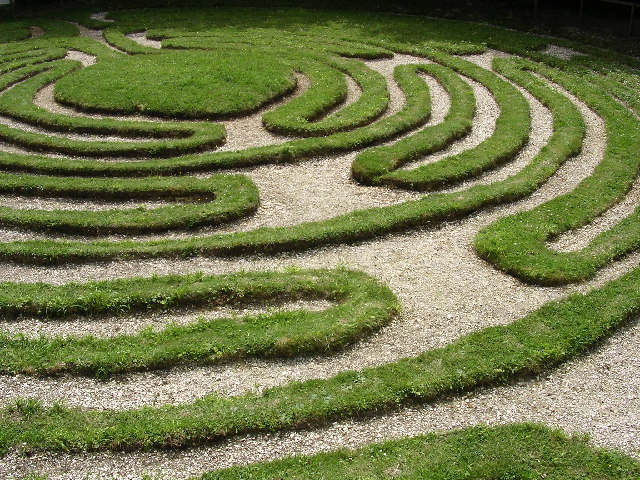
Historically, a turf maze is a labyrinth made by cutting a convoluted path into a level area of short grass, sod, turf or lawn. Some had names such as Mizmaze, Troy Town, The Walls of Troy, Julian's Bower, or Shepherd's Race. This is the type of maze referred to by William Shakespeare in ''A Midsummer Night's Dream'' (Act 2, Scene 2) when Titania (Fairy Queen), Titania says: In some turf labyrinths, the groove cut in the turf is the path to be walked (sometimes marked with bricks or gravel); more commonly the turf itself forms the raised path which is marked out by shallow channels excavated between its twists and turns. Most British examples are based on one of two layouts: the Classical antiquity, Classical or the later, more complex Medieval type which is derived from it. Origins of the turf maze The earliest known use of the classical labyrinth pattern in the British Isles is on the Hollywood Stone, an incised granite boulder from County Wicklow, Ireland, dating from c.& ... [...More Info...] [...Related Items...] OR: [Wikipedia] [Google] [Baidu] |
Sápmi (area)
is the cultural region traditionally inhabited by the Sámi people. Sápmi includes the northern parts of Fennoscandia, stretching over four countries: Norway, Sweden, Finland, and Russia. Most of Sápmi lies north of the Arctic Circle, bounded by the Barents Sea, Norwegian Sea, and White Sea."Lapland." Encyclopædia Britannica. ''Encyclopædia Britannica Online. Encyclopædia Britannica'', 2009. Web. 24 November 2009 http://search.eb.com/eb/article-9047170. In south, Sápmi extends to the counties of Trøndelag in Norway and Jämtland in Sweden. Most of the Sámi population is concentrated in a few traditional areas in the northernmost part of Sápmi, such as Kautokeino and Karasjok. Inari is considered one of the centres of Sámi culture. In past, the Sámi settlement reached much farther to south, possibly to present-day Oslo in west and the lakes Ladoga and Onega in east. Sápmi has never been a sovereign political entity. Since 1970s–1990s, the Sámi have a limi ... [...More Info...] [...Related Items...] OR: [Wikipedia] [Google] [Baidu] |
Scandinavia
Scandinavia is a subregion#Europe, subregion of northern Europe, with strong historical, cultural, and linguistic ties between its constituent peoples. ''Scandinavia'' most commonly refers to Denmark, Norway, and Sweden. It can sometimes also refer to the Scandinavian Peninsula (which excludes Denmark but includes a part of northern Finland). In English usage, Scandinavia is sometimes used as a synonym for Nordic countries. Iceland and the Faroe Islands are sometimes included in Scandinavia for their Ethnolinguistics, ethnolinguistic relations with Sweden, Norway and Denmark. While Finland differs from other Nordic countries in this respect, some authors call it Scandinavian due to its economic and cultural similarities. The geography of the region is varied, from the Norwegian fjords in the west and Scandinavian mountains covering parts of Norway and Sweden, to the low and flat areas of Denmark in the south, as well as archipelagos and lakes in the east. Most of the population ... [...More Info...] [...Related Items...] OR: [Wikipedia] [Google] [Baidu] |
Iceland
Iceland is a Nordic countries, Nordic island country between the Atlantic Ocean, North Atlantic and Arctic Oceans, on the Mid-Atlantic Ridge between North America and Europe. It is culturally and politically linked with Europe and is the region's westernmost and most list of countries and dependencies by population density, sparsely populated country. Its Capital city, capital and largest city is Reykjavík, which is home to about 36% of the country's roughly 380,000 residents (excluding nearby towns/suburbs, which are separate municipalities). The official language of the country is Icelandic language, Icelandic. Iceland is on a rift between Plate tectonics, tectonic plates, and its geologic activity includes geysers and frequent Types of volcanic eruptions, volcanic eruptions. The interior consists of a volcanic plateau with sand and lava fields, mountains and glaciers, and many Glacial stream, glacial rivers flow to the sea through the Upland and lowland, lowlands. Iceland i ... [...More Info...] [...Related Items...] OR: [Wikipedia] [Google] [Baidu] |


