|
Centers Of Action
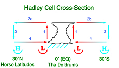
Centers of action are extensive and almost stationary low or high pressure areas which control the movement of atmospheric disturbances over a large area. This does not mean that the position of the center is constant over a specific area but that the monthly atmospheric pressure corresponds to a high or a low pressure. The French meteorologist Léon Teisserenc de Bort was the first in 1881 to apply this term to maxima and minima of pressure on daily charts. The main centers of action in the Northern Hemisphere are the Icelandic Low, the Aleutian Low, the Azores/Bermuda High, the Pacific High, the Siberian High (in winter), and the Asiatic Low (in summer). Sir Gilbert Walker used the same term to relate meteorological elements in a region to weather in the following season in other regions for the Southern Oscillation. Causes In the region called the Horse latitudes, between 30 and 35 degrees of latitude North or South, there is a series of semi-permanent anticyclones on ... [...More Info...] [...Related Items...] OR: [Wikipedia] [Google] [Baidu] |
Low-pressure Area
In meteorology, a low-pressure area, low area or low is a region where the atmospheric pressure is lower than that of surrounding locations. Low-pressure areas are commonly associated with inclement weather (such as cloudy, windy, with possible rain or storms), while high-pressure areas are associated with lighter winds and clear skies. Winds circle anti-clockwise around lows in the northern hemisphere, and clockwise in the southern hemisphere, due to opposing Coriolis force, Coriolis forces. Low-pressure systems form under areas of wind divergence that occur in the upper levels of the Atmosphere of Earth, atmosphere (aloft). The formation process of a low-pressure area is known as cyclogenesis. In Meteorology#Dynamic meteorology, meteorology, atmospheric divergence aloft occurs in two kinds of places: * The first is in the area on the east side of upper Trough (meteorology), troughs, which form half of a Rossby wave within the Westerlies (a trough (meteorology), trough with l ... [...More Info...] [...Related Items...] OR: [Wikipedia] [Google] [Baidu] |
Atmospheric Circulation
Atmospheric circulation is the large-scale movement of air and together with ocean circulation is the means by which thermal energy is redistributed on the surface of the Earth. The Earth's atmospheric circulation varies from year to year, but the large-scale structure of its circulation remains fairly constant. The smaller scale weather systems – mid-latitude depressions, or tropical convective cells – occur chaotically, and long-range weather predictions of those cannot be made beyond ten days in practice, or a month in theory (see chaos theory and the butterfly effect). The Earth's weather is a consequence of its illumination by the Sun and the laws of thermodynamics. The atmospheric circulation can be viewed as a heat engine driven by the Sun's energy and whose energy sink, ultimately, is the blackness of space. The work produced by that engine causes the motion of the masses of air, and in that process it redistributes the energy absorbed by the Earth's surface ne ... [...More Info...] [...Related Items...] OR: [Wikipedia] [Google] [Baidu] |
Gulf Stream
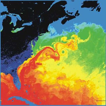
The Gulf Stream, together with its northern extension the North Atlantic Drift, is a warm and swift Atlantic ocean current that originates in the Gulf of Mexico and flows through the Straits of Florida and up the eastern coastline of the United States then veers east near 36 latitude (North Carolina) and moves toward Northwest Europe as the North Atlantic Current. The process of western intensification causes the Gulf Stream to be a northwards accelerating current off the east coast of North America. At about , it splits in two, with the northern stream, the North Atlantic Drift, crossing to Northern Europe and the southern stream, the Canary Current, recirculating off West Africa. The Gulf Stream influences the climate of the coastal areas of the east coast of the United States from Florida to southeast Virginia (near 36 north latitude), and to a greater degree the climate of Northwest Europe. There is consensus that the climate of northwest Europe is warmer than other ar ... [...More Info...] [...Related Items...] OR: [Wikipedia] [Google] [Baidu] |
Bermuda
) , anthem = " God Save the King" , song_type = National song , song = "Hail to Bermuda" , image_map = , map_caption = , image_map2 = , mapsize2 = , map_caption2 = , subdivision_type = Sovereign state , subdivision_name = , established_title2 = English settlement , established_date2 = 1609 (officially becoming part of the Colony of Virginia in 1612) , official_languages = English , demonym = Bermudian , capital = Hamilton , coordinates = , largest_city = Hamilton , ethnic_groups = , ethnic_groups_year = 2016 , government_type = Parliamentary dependency under a constitutional monarchy , leader_title1 = Monarch , leader_name1 = Charles III , leader_title2 = Governor , leader_name2 = Rena Lalgie , leader_title3 = Premier , leader_name3 = Edward David Burt , legislature = Parliament , upper_house = Senate , lower_house = House of Assembly , area_km2 = 53.2 , area_sq_mi = 20.54 , area_rank = , percent_water = 27 , elevation_max ... [...More Info...] [...Related Items...] OR: [Wikipedia] [Google] [Baidu] |
Azores
) , motto= ( en, "Rather die free than subjected in peace") , anthem=( en, "Anthem of the Azores") , image_map=Locator_map_of_Azores_in_EU.svg , map_alt=Location of the Azores within the European Union , map_caption=Location of the Azores within the European Union , coordinates = , subdivision_type = Country , subdivision_name = , established_title=Settlement , established_date=1432 , established_title3=Autonomous status , established_date3=30 April 1976 , official_languages= Portuguese , demonym= ( en, Azorean) , capital_type=Capitals , capital = Ponta Delgada (executive) Angra do Heroísmo (judicial)Horta (legislative) , largest_city = Ponta Delgada , government_type= Autonomous Region , leader_title1=Representative of the Republic , leader_name1=Pedro Manuel dos Reis Alves Catarino , leader_title2= President of the Legislative Assembly , leader_name2= Luís Garcia , leader_title3= President of the Regional Government , le ... [...More Info...] [...Related Items...] OR: [Wikipedia] [Google] [Baidu] |
Thermal Low
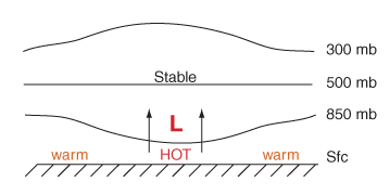
Thermal lows, or heat lows, are non- frontal low-pressure areas that occur over the continents in the subtropics during the warm season, as the result of intense heating when compared to their surrounding environments.Glossary of Meteorology (2009)Thermal Low. American Meteorological Society. Retrieved on 2009-03-02. Thermal lows occur near the Sonoran Desert, on the Mexican plateau, in California's Great Central Valley, in the Sahara, over north-west Argentina in South America, over the Kimberley region of north-west Australia, over the Iberian peninsula, and over the Tibetan plateau. On land, intense, rapid solar heating of the earth's surface causes the heating of the lowest layers of the atmosphere, via re-radiated energy in the infrared spectrum. The hotter air is less dense than surrounding cooler air and rises, leading to the formation of a low pressure area. Elevated areas can enhance the strength of the thermal low because they warm more quickly than the atmosph ... [...More Info...] [...Related Items...] OR: [Wikipedia] [Google] [Baidu] |
Siberia
Siberia ( ; rus, Сибирь, r=Sibir', p=sʲɪˈbʲirʲ, a=Ru-Сибирь.ogg) is an extensive geographical region, constituting all of North Asia, from the Ural Mountains in the west to the Pacific Ocean in the east. It has been a part of Russia since the latter half of the 16th century, after the Russians conquered lands east of the Ural Mountains. Siberia is vast and sparsely populated, covering an area of over , but home to merely one-fifth of Russia's population. Novosibirsk, Krasnoyarsk and Omsk are the largest cities in the region. Because Siberia is a geographic and historic region and not a political entity, there is no single precise definition of its territorial borders. Traditionally, Siberia extends eastwards from the Ural Mountains to the Pacific Ocean, and includes most of the drainage basin of the Arctic Ocean. The river Yenisey divides Siberia into two parts, Western and Eastern. Siberia stretches southwards from the Arctic Ocean to the hills of nort ... [...More Info...] [...Related Items...] OR: [Wikipedia] [Google] [Baidu] |
Météo-France
Météo-France is the France, French national Meteorology, meteorological service. Organisation The organisation was established by decree in June 1993 and is a department of the Ministry of Transportation. It is headquartered in Paris but many domestic operations have been decentralised to Toulouse. Its budget of around €300 million is funded by state grants, aeronautic royalties and sale of commercial services. Météo-France has a particularly strong international presence, and is the French representative at the World Meteorological Organization. The organisation is a leading member of European Organisation for the Exploitation of Meteorological Satellites, EUMETSAT, responsible for the procurement of Meteosat weather satellites. It is also member of the Institute of Space, its Applications and Technologies, Institut au service du spatial, de ses applications et technologies. It also a critical national weather service member of the European Centre for Medium-Range Weathe ... [...More Info...] [...Related Items...] OR: [Wikipedia] [Google] [Baidu] |
Antarctica
Antarctica () is Earth's southernmost and least-populated continent. Situated almost entirely south of the Antarctic Circle and surrounded by the Southern Ocean, it contains the geographic South Pole. Antarctica is the fifth-largest continent, being about 40% larger than Europe, and has an area of . Most of Antarctica is covered by the Antarctic ice sheet, with an average thickness of . Antarctica is, on average, the coldest, driest, and windiest of the continents, and it has the highest average elevation. It is mainly a polar desert, with annual precipitation of over along the coast and far less inland. About 70% of the world's freshwater reserves are frozen in Antarctica, which, if melted, would raise global sea levels by almost . Antarctica holds the record for the lowest measured temperature on Earth, . The coastal regions can reach temperatures over in summer. Native species of animals include mites, nematodes, penguins, seals and tardigrades. Where ve ... [...More Info...] [...Related Items...] OR: [Wikipedia] [Google] [Baidu] |
Université Du Québec
The University of Quebec (French: ''Université du Québec'') is a system of ten provincially run public universities in Quebec, Canada. Its headquarters are in Quebec City. The university coordinates 300 programs for over 87,000 students. The government of Quebec founded the Université du Québec, a network of universities in several Quebec cities. In a similar fashion to other Canadian provinces, all universities in Quebec have since become public. History The University of Quebec system was established in 1968 by the National Assembly of Quebec largely in response to widespread student protests that had broken out in the autumn of that year. In an effort to extend education to more Quebecois students, the government had created a system of CEGEPs to create a facilitated pathway into university. However, Quebec did not have enough French-language universities to accommodate the new influx of students applying after completing CEGEP. Only 40% of CEGEP graduates could be ... [...More Info...] [...Related Items...] OR: [Wikipedia] [Google] [Baidu] |


