|
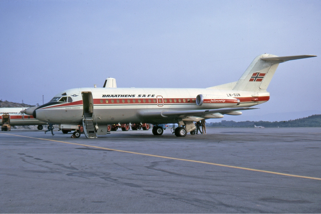
Braathens SAFE Flight 239
Braathen SAFE Flight 239, also known as the Asker Accident ( no, Asker-ulykken), was a controlled flight into terrain of a Fokker F28 Fellowship into Vestmarka in Asker, Norway, on 23 December 1972 at 16:33. The Braathens SAFE aircraft was en route on a scheduled flight from Ålesund Airport, Vigra and crashed during approach to Oslo Airport, Fornebu. Forty of the forty-five people on board the aircraft were killed, making it the deadliest civil aviation accident in Norway until Vnukovo Airlines Flight 2801 in 1996. According to Norwegian newspaper ''Dagbladet'' on 23 December 1992, a Danish citizen died of late complications in 1976. The pilots took a short-cut during approach on runway 06 at Fornebu. Combined with false signals from the instrument landing system (ILS), this caused the pilots to misunderstand their location. This in turn led them to take an incorrect landing path, causing the plane to hit ground in a hilly area. The rescue operation was initiated almost imm ... [...More Info...] [...Related Items...] OR: [Wikipedia] [Google] [Baidu] |
Controlled Flight Into Terrain
In aviation, a controlled flight into terrain (CFIT; usually ) is an accident in which an airworthy aircraft, under pilot control, is unintentionally flown into the ground, a mountain, a body of water or an obstacle. In a typical CFIT scenario, the crew is unaware of the impending disaster until it is too late. The term was coined by engineers at Boeing in the late 1970s. Accidents where the aircraft is out of control at the time of impact, because of mechanical failure or pilot error, are not considered CFIT (they are known as ''uncontrolled flight into terrain'' or ''UFIT''), nor are incidents resulting from the deliberate action of the person at the controls, such as acts of terrorism or suicide by pilot. According to Boeing in 1997, CFIT was a leading cause of airplane accidents involving the loss of life, causing over 9,000 deaths since the beginning of the commercial jet aircraft. CFIT was identified as a cause of 25% of USAF Class A mishaps between 1993 and 2002. Accord ... [...More Info...] [...Related Items...] OR: [Wikipedia] [Google] [Baidu] |
Lowest Safe Altitude
In aviation (particularly in air navigation), lowest safe altitude (LSALT) is an altitude that is at least 500 feet above any obstacle or terrain within a defined safety buffer region around a particular route that a pilot might fly. The safety buffer allows for errors in the air by including an additional area that a pilot might stray into by flying off track. By flying at or above this altitude a pilot complies with terrain clearance requirements on that particular flight leg. Australian definition * The minimum LSALT is 1500 feet. * LSALT is 1360 feet above the highest terrain where any obstacle thereon is less than 360 feet above the terrain, or there is no charted obstacle. * LSALT is 1000 feet above the highest obstacle which is greater than 360 feet above the terrain. For example, if there is an obstacle at 200 feet above terrain of 2500 feet, LSALT is 2500 feet (terrain height) + 1360 feet (clearance height), for an LSALT of 3860 feet; if there is an obstacle at 450 fee ... [...More Info...] [...Related Items...] OR: [Wikipedia] [Google] [Baidu] |
Lahti Longwave Transmitter
The Lahti longwave transmitter was a facility for longwave transmission on the Radio Hill in Lahti, Finland on 252 kHz. It was inaugurated in 1927 and used a T-type aerial strung between two freestanding steel framework towers. The Lahti longwave transmitter was shut down in 1993. Nowadays the facility is used as a museum. The red-and-white towers are still standing and form a local landmark. Nearby is lake Mytäjäinen. See also * List of towers Several extant building fulfill the engineering definition of a tower: "a tall human structure, always taller than it is wide, for public or regular operational access by humans, but not for living in or office work, and are ''self-supporting' ... External links * *http://www.skyscraperpage.com/diagrams/?b45639 *http://www.skyscraperpage.com/diagrams/?b45640 Towers completed in 1927 Communication towers in Finland Transmitter sites in Finland Lahti Museums in Päijät-Häme 1927 establishments in Finland {{Eu ... [...More Info...] [...Related Items...] OR: [Wikipedia] [Google] [Baidu] |
Ministry Of Transport And Communications (Norway)
The Royal Norwegian Ministry of Transportation (; ) is a Norwegian ministry established in 1946, and is responsible for transportation in Norway. The ministry was responsible for communication infrastructure until may 2019, when the responsibility for the Norwegian Communications Authority was transferred to Ministry of Local Government and Regional Development. Since October 2021, the ministry has been headed by Jon-Ivar Nygård ( Labour Party). The department must report to the parliament ( Stortinget). Organization The ministry has 135 employees and is divided into the following sections: * Political staff * Communication Unit * Department of Management, Administration and Public Safety and Security * Department of Civil Aviation, Postal services and Procurement of Non-Commercial Transport * Department of Planning and Rail transport * Department of Coastal Affairs and Environment * Department of Public Roads, Urban Mobility and Traffic Safety Political staff * State Secretar ... [...More Info...] [...Related Items...] OR: [Wikipedia] [Google] [Baidu] |
Altimeter
An altimeter or an altitude meter is an instrument used to measure the altitude of an object above a fixed level. The measurement of altitude is called altimetry, which is related to the term bathymetry, the measurement of depth under water. The most common unit for altimeter calibration worldwide is hectopascals (hPa), except for North America (other than Canada ) and Japan where inches of mercury (inHg) are used. To obtain an accurate altitude reading in either feet or meters, the local barometric pressure must be calibrated correctly using the barometric formula. History The scientific principles behind the altimeter were first written by Rev. Alexander Bryce a Scottish minister and astronomer in 1772 who realised that the principles of a barometer could be adjusted to measure height. Pressure altimeter Altitude can be determined based on the measurement of atmospheric pressure. The greater the altitude, the lower the pressure. When a barometer is supplied with a nonlinear ... [...More Info...] [...Related Items...] OR: [Wikipedia] [Google] [Baidu] |
Copenhagen
Copenhagen ( or .; da, København ) is the capital and most populous city of Denmark, with a proper population of around 815.000 in the last quarter of 2022; and some 1.370,000 in the urban area; and the wider Copenhagen metropolitan area has 2,057,142 people. Copenhagen is on the islands of Zealand and Amager, separated from Malmö, Sweden, by the Øresund strait. The Øresund Bridge connects the two cities by rail and road. Originally a Viking fishing village established in the 10th century in the vicinity of what is now Gammel Strand, Copenhagen became the capital of Denmark in the early 15th century. Beginning in the 17th century, it consolidated its position as a regional centre of power with its institutions, defences, and armed forces. During the Renaissance the city served as the de facto capital of the Kalmar Union, being the seat of monarchy, governing the majority of the present day Nordic region in a personal union with Sweden and Norway ruled by th ... [...More Info...] [...Related Items...] OR: [Wikipedia] [Google] [Baidu] |
Flight Recorder
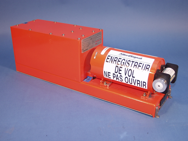
A flight recorder is an electronic recording device placed in an aircraft for the purpose of facilitating the investigation of aviation accidents and incidents. The device may often be referred to as a "black box", an outdated name which has become a misnomer—they are now required to be painted bright orange, to aid in their recovery after accidents. There are two types of flight recording devices: the flight data recorder (FDR) preserves the recent history of the flight through the recording of dozens of parameters collected several times per second; the cockpit voice recorder (CVR) preserves the recent history of the sounds in the cockpit, including the conversation of the pilots. The two devices may be combined into a single unit. Together, the FDR and CVR objectively document the aircraft's flight history, which may assist in any later investigation. The two flight recorders are required by international regulation, overseen by the International Civil Aviation Organiz ... [...More Info...] [...Related Items...] OR: [Wikipedia] [Google] [Baidu] |
Braathens SAFE Fokker F-28-1000 Manteufel
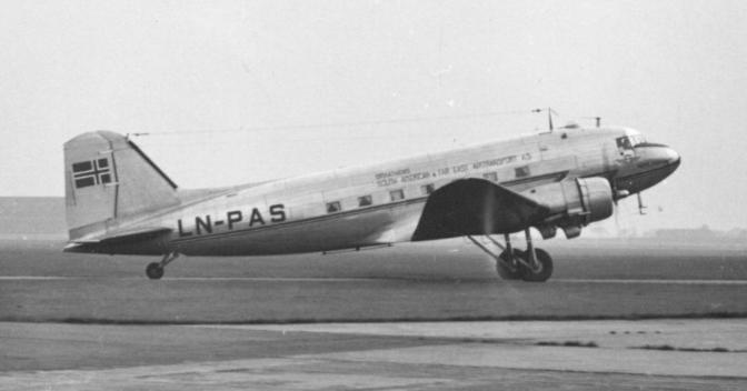
Braathens ASA, until 1997 Braathens South American & Far East Airtransport A/S and trading as Braathens SAFE, was a Norwegian airline which operated from 1946 until it merged with Scandinavian Airlines (SAS) in 2004 to become SAS Braathens. For most of its history, Braathens was the largest domestic airline in Norway, but did not operate an international network for many years. Its main hubs were Oslo Airport, Fornebu and later Oslo Airport, Gardermoen, and briefly Stockholm-Arlanda Airport. The airline operated 118 aircraft of 15 models, mostly Boeing 737 variants. Braathens served 53 airports and 50 cities with scheduled services through its history. The airline was founded in 1946 by Ludvig G. Braathen and originally used a fleet of Douglas DC-4 aircraft on routes to the Far East and South Africa. From 1954 the airline was forced to operate all its scheduled flights domestically, where it used de Havilland Herons. Braathens SAFE retained an international charter service us ... [...More Info...] [...Related Items...] OR: [Wikipedia] [Google] [Baidu] |
Norwegian Red Cross Search And Rescue Corps
The Norwegian Red Cross Search and Rescue Corps (NRKH) was created in 1932 as a support for civil society in the event of war, and particularly with gas attacks in other cities. Today, there are over 300 local Search and Rescue Corps with over 12,000 members, where all members are qualified first aiders. The Search and Rescue Corps's main task is to assist police in search and rescue operations especially during disasters. In addition, the corps gives medical manpower to various events in the community, doing first aid instruction, and in some locations, ambulance services. All efforts from the membership are voluntary. The equipment used is also paid for with funds collected through volunteer efforts. Education Anyone who wants to be an active member in the corps must complete a basic course in first aid and introduction to Red Cross. They can then participate as an aspirant. When they have completed their full training of First Aid, Radio Communications, and Basic course in ... [...More Info...] [...Related Items...] OR: [Wikipedia] [Google] [Baidu] |
Joint Rescue Coordination Centre Of Southern Norway
The Joint Rescue Coordination Centre of Southern Norway or JRCC SN ( no, Hovedredningssentralen i Sør-Norge) is a rescue coordination center located in Sola which is responsible for coordinating major search and rescue (SAR) operations in Norway south of the 65th parallel north. Established in 1970, it is a government agency subordinate to the Ministry of Justice and Public Security and led by the Chief of Police of Rogaland Police District. The agency has twenty-three employees and has at least two rescue controllers at work at any time. The center is able to call on resources from twenty-one police districts, land, sea and air ambulance services, fire departments, the Coast Guard, the Royal Norwegian Air Force's 330 Squadron, which operates the Westland Sea King SAR helicopters, the Norwegian Society for Sea Rescue and other governmental, commercial and volunteer resources. Communication can be relayed via Telenor Maritime Radio and Avinor's air traffic control. The rest of ... [...More Info...] [...Related Items...] OR: [Wikipedia] [Google] [Baidu] |
Search And Rescue
Search and rescue (SAR) is the search for and provision of aid to people who are in distress or imminent danger. The general field of search and rescue includes many specialty sub-fields, typically determined by the type of terrain the search is conducted over. These include mountain rescue; ground search and rescue, including the use of search and rescue dogs; urban search and rescue in cities; combat search and rescue on the battlefield and air-sea rescue over water. International Search and Rescue Advisory Group (INSARAG) is a UN organization that promotes the exchange of information between national urban search and rescue organizations. The duty to render assistance is covered by Article 98 of the UNCLOS. Definitions There are many different definitions of search and rescue, depending on the agency involved and country in question. *Canadian Forces: "Search and Rescue comprises the search for, and provision of aid to, persons, ships or other craft which are, or a ... [...More Info...] [...Related Items...] OR: [Wikipedia] [Google] [Baidu] |
Sandvika
Sandvika () is the administrative centre of the municipality of Bærum in Norway. It was declared a city by the municipal council in Bærum on 4 June 2003. Sandvika is situated approximately west of Oslo. It is the main transportation hub for Western Bærum, and has a combined bus and railway station. Sandvika is also one of the stops along the route of the Airport Express Train. Sandvika also has Scandinavia's largest super mall, Sandvika Storsenter, with 190 stores and a total area of . On 13 March 2013, the previously pedestrianized main street was opened for car traffic and on-street parking. Sandvika used to be home to the BI Norwegian Business School, which moved to new surroundings in Nydalen, Oslo in August 2005. The building was, after some refurbishing, converted into the home of Sandvika High School. Another school in Sandvika is Norges Realfagsgymnas NRG (Norwegian school of maths and science), a combined secondary school and high school. It lies in Skytterdalen and ... [...More Info...] [...Related Items...] OR: [Wikipedia] [Google] [Baidu] |


